North Thailand GPS map on Andriod OS - It works!!!!!!

KTMphil

Senior member
Joined
Jan 11, 2011
Location
Chiang Mai, Thailand
Bikes
2007 KTM 990 Adventure Suzuki DRZ 400
With more and more people using their smart phones & tablet devices for navigation, we wanted to be able to get the "North Thailand On & Off-Road GPS Map" to run on an android operating system.


Well, we've finally achieved it last night. A friend who's pretty good with IT played around with it and has managed to get it to run on the OruxMaps application for android OS. This application is currently a free download from the play store.


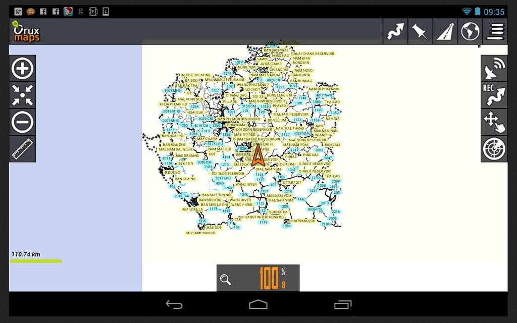
It was pretty exciting opening it for the first time last night, we had no idea whether this was going to work. Below is the first image we saw in the OruxMaps application, with the "North Thailand On & Off-Road GPS Map" data showing on the screen, this meant there was a fairly good chance it had worked! This is the whole of north Thailand in the image below (ie zoomed out)

all nt.jpg


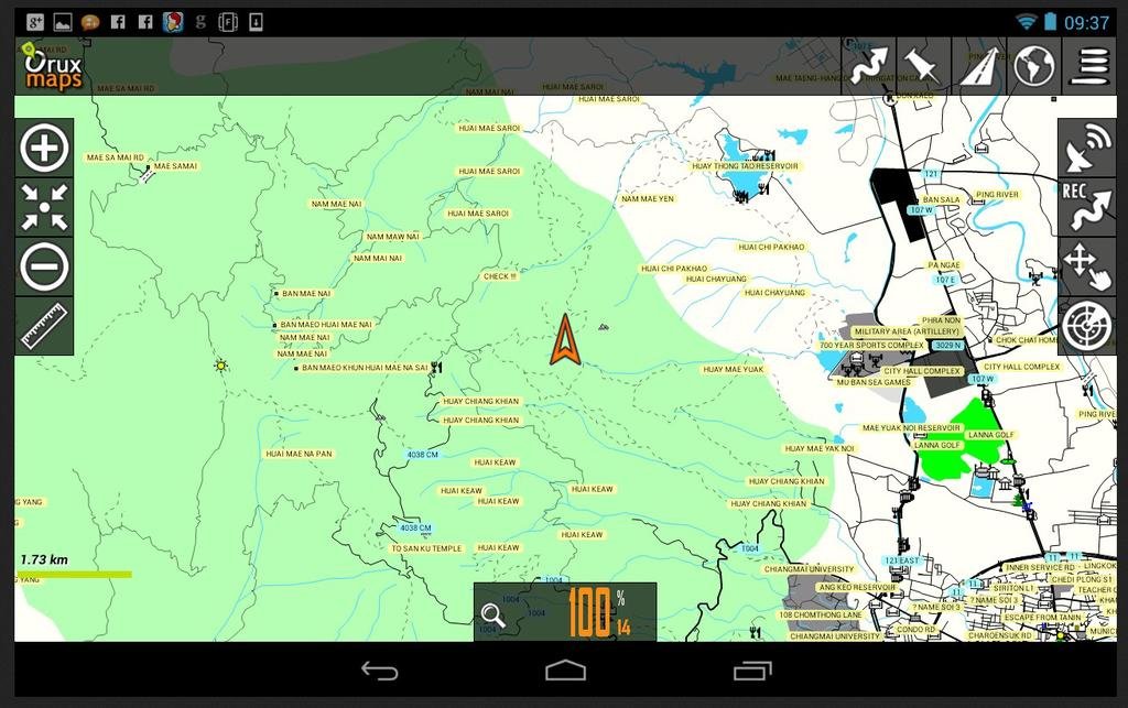
What was highly important, as road data is available from many sources on the internet, was that the unique off-road/ trail data contained on the "North Thailand On & Off-Road GPS Map" showed correctly and was usable. It was, take a look at the zoomed image of Doi Suthep mountain, which is just west of Chiang Mai city, all the trail data was there and in a usable form. This can be used for trail riding, routes can be planned using the OruxMaps software and it will auto route - This is fantastic.

dst.jpg


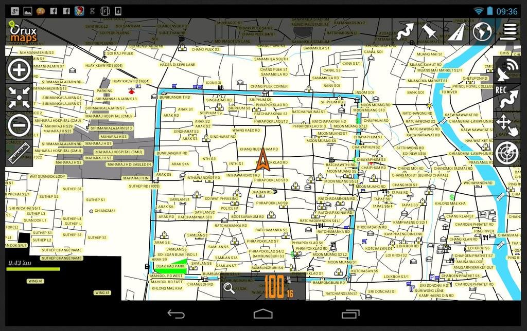
We then did a check of the city data, to see how usable it would be. Below is a zoom on Chiang Mai city moat square, again all very usable as a navigation tool, this is all very impressive.

cnx city.jpg
 
For those who want to try it out, the link is here: Oruxmaps (Android) (Page 1) / Garmin maps / OpenStreetMap Forum - (Android app) can now read Garmin img tiles! Just store the a gmapsupp.img (or individual garmin img tile) in the default offline Oruxmaps folder (mapfiles) and you can browse the map. Colours and labels aren't optimal but I'm happy it's finally possible.

However, you will need the latest version of Orux (version 4.8.61) which you can get here:
http://www.1mobile.com/oruxmaps-97050.html and you will need to have Garmin maps which are not locked and preferably consist of 1 tile as Orux apparently only reads the last loaded map tile.
 
Looks good.
So what did you do, overlay your Garmin data on top of OSM data?
I've been playing with this stuff for 10+ years since the early days of CGSMapper and now OSM.
I use OSMAnd on the phone and the Garmin download from Lambertus's site for Thailand.
 
Very cool to get the map up and running on the Smartphones.

So if someone coming into Chiang Mai on holiday around the north and they don't have their GPS but have their Android Smartphone this would solve all their navigation needs in full. A tip of the hat to those behind the scenes for figuring this out.
 
One small statement that needs clearing up is.

you will need to have Garmin maps which are not locked

Which means the North Thailand maps (and ESRI / SEA / Etc garmins) wont work out of the box.

Its a great tech test, but if my guesses of the comments above are correct this rules out 'normal users' for being able to buy the maps and run them ??

Of course there are ways.. But out of respect for Phils mapping system thats not for discussion here.
 
Great info !

Today I installed Oruxmaps on my Samsung S2 phone.
I have an old gmapsupp.img map of laos-cambodia on my 60csx
It was just a matter of connecting both devices to my laptop and copy/paste the gmapsupp.img from my gps to the orux map file on my phone.
So the map comes up on the phone but the phones 1.2ghz processor struggles with it when scrolling around.
Haven't tried doing anything with it yet.
 
Oruxmap on Samsung S2

Quite liking the features of the oruxmaps app on my S2.

I recorded a 3.3km track using the default settings.
Phone was in airport mode so no data usage, just referencing of the gps chip (whatever it is) in the phone.

Once the track was recorded as a gpx, I bluetoothed it to my laptop.

orux maps screenshot.jpg

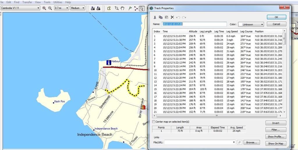
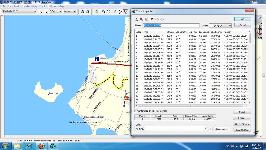
Screen shot of track and track properties.

In a previous post I commented that its slow to scroll around the map on the S2. Have since found if you give it a minute or two to fully load the map, then it scrolls around OK.

It would be good if the phone could be set to receive and make calls, but the gps only used the phones standalone gps, rather than referencing of phone towers and using up phone data credit.
Does anyone know if its possible to set it that way ?
 

Attachments

  • orux maps screenshot.jpg
    orux maps screenshot.jpg
    105.3 KB · Views: 445
Quite liking the features of the oruxmaps app on my S2.

It would be good if the phone could be set to receive and make calls, but the gps only used the phones standalone gps, rather than referencing of phone towers and using up phone data credit.
Does anyone know if its possible to set it that way ?

Will see if I can figure out how to do that but, as I don't have an Android phone, you guys will have to do the testing.
 
Will see if I can figure out how to do that but, as I don't have an Android phone, you guys will have to do the testing.

Thx Auke, I've worked it out now
On the Samsung S2, in settings, touch "data usage" and select "off ".
This disables data but still allows making/receiving calls.
I checked my balance then recorded a 30km track. Balance was unchanged.
 
Thx Auke, I've worked it out now
On the Samsung S2, in settings, touch "data usage" and select "off ".
This disables data but still allows making/receiving calls.
I checked my balance then recorded a 30km track. Balance was unchanged.

OK, good to hear that as that is what other people using this program mentioned on the web. The maps are on the phone and so you don't need a connection to the WWW or other things to see where you are.
 
What is the easiest way to upload established waypoints from your GPS to this feature on an Android phone?
 
What is the easiest way to upload established waypoints from your GPS to this feature on an Android phone?


Take a look at this, there is a procedure to doing it:


empty.gif
Importing waypoints


empty.gif
Rick A on Wed Jul 06, 2011 2:05 pm

I followed the instructions:
Go to navaid.com and go to GPX link: navaid.com/GPX/
Follow the instructions and choose what you want to include in your database, like airports, vor and ndb's etc.
It'll create your file which you can download then.
Move that file to /mnt/sdcard/oruxmaps/tracklogs on your phone/device.
Open Oruxmaps, load a map, go to menu > waypoints > menu > more > Import wpts.
Choose your file you downloaded to the phone.


After creating the database, it is saved as an xml file. I copied that to /mnt/sdcard/oruxmaps/tracklogs and di an import database. But after that runs, I keep getting an error message saying: Error when loading waypoints.
What am I doing wrong?


gregt wrote:Hello
I've do exactly the same procedure like Rick ... newest version of Oruxmap from 11.11.11
and i've found the same result... the database was small , for Poland only airports it was 120 points
can I any way to find out a problem ?
second question ...
I do not found the proper forum topic ... about : how to import waypoints from oziexplorer or garmin
... let say .WPT format .... , there is no procedure ? or any complicated ?

But from the other hand, there is great soft, thanks, I'am comparing it with oziexplorer and androzic ... I've found many advantages ...
one thing will be nice ... screen designer ... other parameters user need on bicycle other in air ....
will be nice to customize screen, with fonts place of windows etc ...
do you plan such feature ?
Have a nice day
Gregory


Hi, Gregory;

1.-Send me the gpx file; I will try.--> oruxuro@gmail.com

2.-You can use gpsbabel application to convert any format to gpx/kml

3.-About screen design; you can play with different dashboards (up-down), different sizes (old dashboard, alternative ), buttons, ... All the settings can be found in 'User interface'.

orux
 
The Orux Manual can be downloaded from here: http://www.oruxmaps.com/oruxmapsmanual_en.pdf The Manual has been translated by a computer program into English so the translated version is sometimes difficult to understand.

Basically you can import tracks, waypoints, routes by using the button "Routes - Load Files" which gives you the option to select waypoint/routes files which you can then import (.gpx or .kml file format).

Another option is to go here: http://androgeoid.com/2010/11/turn-your-android-into-a-true-handheld-gps-with-oruxmaps-part-i-interface/ where you can read a tutorial (in 5 parts) which takes you through all the tricks.
 
What is the easiest way to upload established waypoints from your GPS to this feature on an Android phone?

Similar procedure to loading a track

Save the waypoints you want as a gpx file on your computer
Connect phone to computer and copy/paste that file to Oruxmaps/tracklogs
Open "waypoints" on the phone
Press bottom left corner (on samsung s2) and a menu comes up.
Select import wpts
The gpx waypoints file you copy/pasted should appear in the list.
Select that file (pick file) and all your waypoints will load
Select any waypoint and then press the "globe with eye" icon top left of screen.
Map should open to that waypoint.
 
Awesome Bill, thanks heaps. Off to try and make this damn Smartphone do something useful for once.
 
Well that didn't work for me, sadly I'm unable to save a file of my waypoints as a .gpx file. I get an error message and this merssage is too long to allow me to screen capture since its so large nor copy and paste it. Any hints? I can save the file as a .gdb file but Orynx is not reading the .gdb file.
 
Well that didn't work for me, sadly I'm unable to save a file of my waypoints as a .gpx file. I get an error message and this merssage is too long to allow me to screen capture since its so large nor copy and paste it. Any hints? I can save the file as a .gdb file but Orynx is not reading the .gdb file.

I'm no expert either but the following is what worked for me.

Connect gps (60csx in my case) to computer and open mapsource.
Select transfer from device and tick waypoint box, untick anything you dont want.
You've then got all your waypoints on mapsource
Save as gpx file.
 
The method Bill mentions should work but you can also load a .gdb file in Mapsource and save it as a .gpx file. The web indicates that, in case you have a very large .gpx file, you are asking for problems when you transfer the file to the phone and no solution is given on how to solve that kind of problem. In case you have a very large .gpx file try splitting it up into smaller parts and see if that works.
 
samsung usb connector

I just bought a usb connector ($5) and micro sd card reader ($2) for my samsung S2 smartphone

This allows to me to take gpx tracks from my garmin gps sd card and open them in orux maps on my smartphone.

So no need to carry a laptop/netbook to transfer between devices.

Can provide more details if anyone interested
 
Bill - that's the first time i've heard that this is possible great news!


I just bought a usb connector ($5) and micro sd card reader ($2) for my samsung S2 smartphone

This allows to me to take gpx tracks from my garmin gps sd card and open them in orux maps on my smartphone.

So no need to carry a laptop/netbook to transfer between devices.

Can provide more details if anyone interested
 
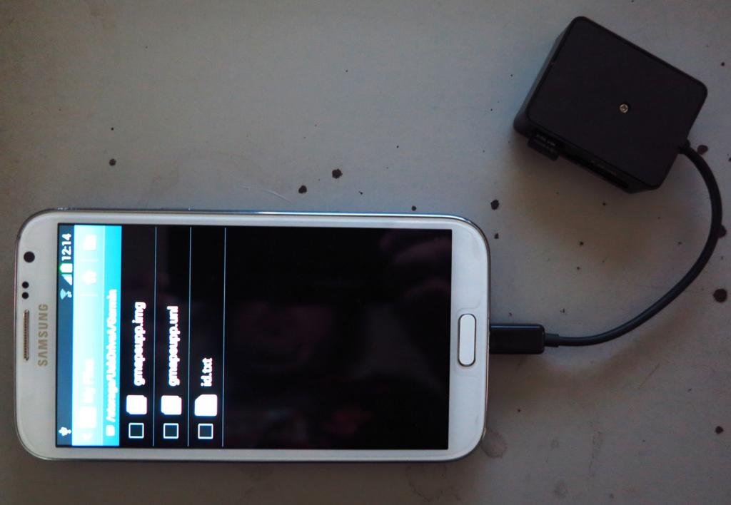
I Just gave it a shot with the Samsung Galaxy Note 2 Android phone. The Garmin SD memory card was visible on the Samsung Android phone but no track files showing. The track files on the Garmin GPS unit must be configured to save to the internal memory of the Garmin GPS device and not to the SD memory card, I will change the settings and so that the track files/ data go to the SD memory card & then they should be visible on the Android phone.


note 2 garmin.jpg
 
I Just gave it a shot with the Samsung Galaxy Note 2 Android phone. The Garmin SD memory card was visible on the Samsung Android phone but no track files showing. The track files on the Garmin GPS unit must be configured to save to the internal memory of the Garmin GPS device and not to the SD memory card, I will change the settings and so that the track files/ data go to the SD memory card & then they should be visible on the Android phone.


View attachment 13219

Yep, I have my 60csx set to log tracks to sd card at end of day.

Just for a laugh I left the sd card in the 60csx, and connected the 60csx usb cable direct to the samsung phone usb adaptor, ie, no card reader.
Then turn garmin on, (no batteries, it ran off the phone power) and set to "usb mass storage" mode.
It worked just as well, automatically opened gpx files in oruxmaps.
 
So you must have a special cable with mini USB (fits the Garmin 60 csx) one end and "new style" micro USB (fits the Samsung phone) the other end? I don't think I've ever seen such a thing?

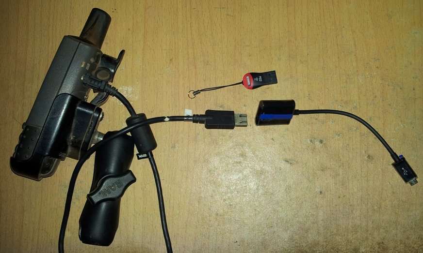
Phil, I did it with two cables.

The garmin gps usb cable plugs into the samsung usb adaptor cable
or
You can remove the sd card from the gps and use a card reader plugged into the samsung usb adaptor cable, or use a cable like the one shown in your post.

20130107_181102.jpg
 
Hi there ,so how did it go? Could you actually make it work over time?I was considerating buying the sd cards (Th/Laos) and use them with a Samsung tablet..


For those who want to try it out, the link is here: Oruxmaps (Android) (Page 1) / Garmin maps / OpenStreetMap Forum - (Android app) can now read Garmin img tiles! Just store the a gmapsupp.img (or individual garmin img tile) in the default offline Oruxmaps folder (mapfiles) and you can browse the map. Colours and labels aren't optimal but I'm happy it's finally possible.

However, you will need the latest version of Orux (version 4.8.61) which you can get here:
http://www.1mobile.com/oruxmaps-97050.html and you will need to have Garmin maps which are not locked and preferably consist of 1 tile as Orux apparently only reads the last loaded map tile.
 
Hi .wondering if you were successful over time in using (on Samsung Android) the off road maps TH/Laos ,available in chiang mai (?) thanks
 
So you must have a special cable with mini USB (fits the Garmin 60 csx) one end and "new style" micro USB (fits the Samsung phone) the other end? I don't think I've ever seen such a thing?

Seen little block connector packs with all versions USB mini micro etc to an old school USB so with the block and cable you have the options.
 
This inability to deal with Img files for route planning is the biggest drawback I have with my iPad now..
 
Hi .wondering if you were successful over time in using (on Samsung Android) the off road maps TH/Laos ,available in chiang mai (?) thanks

Yes, you can use Garmin maps on your Samsung Android when you install Orux on the Samsung Android. The Offroad mas forthe North off Thaland as well as the map for Laos is available at Riders Corner in Chiangmai and at Eagle GPS in Panthip Plaza (2nd floor) also in Chiangmai.
 
Is eagle selling unlocked versions now then.. I figured the security aspect, and protection of the IP made this a bit of a difficult choice for the content owner ?
 
The North Thailand and the Laos map are not locked anymore due to various reasons with one being that the locking system often resulted in that the map could not be unlocked (wrong serial number of the GPS, people wanting to combine the map with other maps in particular with older GPS'es which can only use very few names for the maps) and this took a lot of time and effort to solve these problems. The other reason is that it is has become so easy to unlock the map with software available on the WWW (did a few years back a demo in PP when someone claimed that the map could not be unlocked - took me one minute to give them the unlocked version) that the added effort to add the lock to the map was for me no longer worth my time as I reason that the majority of the people can't be bothered to unlock the map.
 
sounds great ..so an adaptor +a tablet with Orux should make a decent /usable GPS ...thanx :ride:

PS ..but wait, the tablet do have a micro SD slot ,is that gona work without the need of adaptor?can the maps be saved to the (tablet) unit ?so no need for the (maps ) card afterwards ,and be able to save pics /video separatly on another SD
 
Yes, you can use Garmin maps on your Samsung Android when you install Orux on the Samsung Android. The Offroad mas forthe North off Thaland as well as the map for Laos is available at Riders Corner in Chiangmai and at Eagle GPS in Panthip Plaza (2nd floor) also in Chiangmai.

i 've seen those maps at Eagle and wanted to buy 'em.. i went there with the tablet but the lady said I couldn't use them (?) i showed her Orux ,she replied again ,no possible ..
not sure now, she also probably wanted to sell a GPS unit as well..(?) :?
 
i 've seen those maps at Eagle and wanted to buy 'em.. i went there with the tablet but the lady said I couldn't use them (?) i showed her Orux ,she replied again ,no possible ..
not sure now, she also probably wanted to sell a GPS unit as well..(?) :?

Yes, probably she wanted to sell a GPS as well but you can believe me that the maps are unlocked but don't tell the lady at Eagle GPS.
 
Yes, probably she wanted to sell a GPS as well but you can believe me that the maps are unlocked but don't tell the lady at Eagle GPS.

ok fair enough,if u garantee worth to give it a try..is this the GPS system you currently use and it's tested?can the maps be saved to the (tablet) unit ?so no need for the (map ) card in afterwards ,and be able to save pics /video separately on another SD ?thanx again for the precious info!
PS i'll just buy them 'for a friend' with a gps
 
I still think a tablet makes a poor real world use gps.. Good for trip planning perhaps but not actually riding.
 
well..both have their pro/cons.. a big pro for the tablet (from my point of view) is a large screen.does have a GPS although in many cases can go on line ,is a phone ,and I carry it anyway... just doesn't make good coffee.. :hmm


I still think a tablet makes a poor real world use gps.. Good for trip planning perhaps but not actually riding.
 
For navigation while riding I have Google Maps or TOM TOM reading me directions. I have a stereo bluetooth headset or I use the ear buds.

For transfering files onto my phones MicroSD card I use something like this.

TF-Micro-SD-USB-20-Memory-Card-Reader-Yellow_320x320.jpg

Google maps requires a live connection to the internet to work. But you can download about a 70mile square area an cache it.
 
Back
Top Bottom