Garmin Edge 520 Map Issues

solitone

Member
Joined
Nov 24, 2018
Location
Italy
Ok most likely your unit will only allow files with the names gmapsupp or gmapprom at any one time

I have a Garmin Edge 520, and has a map called gmapbmap.img. Time ago I replaced this file (which Garmin provided) with a .img file I generated with QLandkarte GT, based on several .img tiles based on OpenStreetMap data. I gave that file the same name (gmapbmap.img) so that it was visible on my Edge 520 unit.

I have also a file called gmapbmap.sum (that I didn't touch), plus another pair of files (gmaptz.img and gmaptz.sum) that I believe have to do with time zones but don't know their real function, and I didn't touch either.

Screenshot 2018-11-24 at 07.58.18.png


If you use Basecamp i suggest downloading this program for your operating system.

JaVaWa GPS-tools | JaVaWa Device Manager

Hook up your unit and close basecamp and run the program, it will scan your device and display your map files, ensure your maps have a basecamp image enabled next to them, close the program and start basecamp, your new map will now be displayed in basecamp.

I've tried JaVaWa Device Manager, and I see my unit and my two maps there:
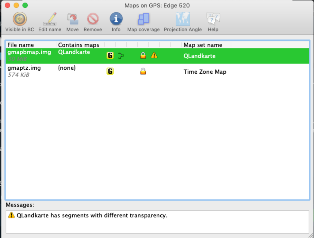
Screenshot 2018-11-24 at 08.04.22.png

As you see there is a lock meaning read-only and I can't change the visibility property or anything. Is there anything I can do?

I've also tried and copied the gmapbmap.img file in a USB thumb drive, inside a Garmin folder (as explained in this post). JaVaWa Device Manager sees that drive as a Garmin device and shows my map, and there I can set the property "Visible in BC" to "yes". However, although BaseCamp sees the USB drive as a Garmin device, I can't find that map anywhere in BaseCamp.

I use BaseCamp 4.7.0 for macOS.
 
Firstly welcome to Ride Asia !!!

From what i see from your screenshots the padlock symbols are correct in terms of the file names you are using normally these are used for pre-installed map segments for time zones and a world map which should not be removed. Garmin regards your map you have installed as pre-installed maps and in order to be able to change its visibility, you much change the file name.

Rename it gmapsupp.img or gmapprom.img

This should solve your problem but you may have to reinstall the Garmin worldwide base map, let me know how you get on.
 
Hi, and thanks for your reply!

Rename it gmapsupp.img or gmapprom.img
If I rename to gmapsupp.img JaVaWa Device Manager shows me an error: "The linked device doesn't support files with the name gmapsupp.img". Similar thing if I use the name gmapprom.img.

This is why I used the name gmapbmap.img, it was the only way I found to see that map on my device.

This should solve your problem but you may have to reinstall the Garmin worldwide base map, let me know how you get on.

Unfortunately I can't have both maps on my device. It has limited capacity (105 MB), and Garmin Base Map alone is 49 MB--there is not enough space for both maps.
 
Hi, and thanks for your reply!


If I rename to gmapsupp.img JaVaWa Device Manager shows me an error: "The linked device doesn't support files with the name gmapsupp.img". Similar thing if I use the name gmapprom.img.

This is why I used the name gmapbmap.img, it was the only way I found to see that map on my device.


Unfortunately I can't have both maps on my device. It has limited capacity (105 MB), and Garmin Base Map alone is 49 MB--there is not enough space for both maps.

How very strange, Garmin are well known for being troublesome but your unit should see and read the file types i mentioned i would take a look at this web page which may help, but i think its the mapset you have installed which is causing the issues, try another map from say OSM.

How to install bike maps on the Garmin Edge 520 - OneManEngine
 
i would take a look at this web page which may help, but i think its the mapset you have installed which is causing the issues, try another map from say OSM.

How to install bike maps on the Garmin Edge 520 - OneManEngine

Hi,

also the guide you linked says that Edge 520 expects the map name be 'gmapbmap':
go back to the downloaded file and rename the downloaded ‘gmapsupp’ to ‘gmapbmap’ (keep the .img extension if you see it).

and I can confirm that if the map has a different name it is not seen by this unit.

What do you think of the other thing I wrote about? Is BaseCamp 4.7.0 still able to use .img maps loaded in the '/Garmin' directory of any removable drive (memory card in a card reader, USB flash drive, but NOT an external hard drive), as explained in this post? I didn't manage to do it.
 
Obviously the Edge appears to read data differently to most other Garmin devices, its a pity it doesn't have an SD card that would maybe help your case. Regarding Basecamp for Mac 4.7.0 it has no issues reading .img files on my other devices or maps stored on a usb drive or sd card, but in order for Basecamp to see them they need to be a folder named Garmin as with maps on a device.

I would suggest as i said before download another map, remove the QLandkarte map from your device and add you the newly downloaded map, i still feel the issue is with the QLandkarte map file.
 
Regarding Basecamp for Mac 4.7.0 it has no issues reading .img files on my other devices or maps stored on a usb drive or sd card, but in order for Basecamp to see them they need to be a folder named Garmin as with maps on a device.

I would suggest as i said before download another map, remove the QLandkarte map from your device and add you the newly downloaded map, i still feel the issue is with the QLandkarte map file.

Yes, you're right, I can see an Openfietsmap from BaseCamp both when accessing a USB drive, and when accessing my Edge device. If I keep the original file name 'qmapsupp.img' I get the usual error from JaVaWa DM, and I can't see the map on the Edge. If I rename it to 'gmapbmap.img' I don't have errors, JaVaWa DM can't edit any of its properties, I can see it on the Edge and also (surprise surprise) I can still see it in BaseCamp.

Now I need to understand why maps generated with QLandkarte have this issue.
 
"Now I need to understand why maps generated with QLandkarte have this issue."

I am not familiar with this mapping system and cannot download it to my Mac for review, i would stick with OSM Free worldwide Garmin maps from OpenStreetMap you may want to consider the Lite map versions for cyclists if you are trying to save space on your device.
 
Back
Top Bottom