GARMIN MAPSOURCE AND RELATED INFORMATION

Lone Rider

Blokes Who Can
Joined
Jan 29, 2011
Location
Chiangmai
Bikes
4 Wheels
Garmin Mapsource and Garmin Trips and Waypoint Manager was/is supplied free with certain GPS models like the 60, 76 and others but not anymore with the Nuvi's and Zumo's. With Garmin Mapsource you can install maps and transfer them to the GPS (something which is not possible with Garmin Trip and Waypoint Manager).

Unfortunately, if you don't have Mapsource, you won't be able to install these and any other 3rd party Garmin GPS maps to your GPS unit. Other advantages of Mapsource are:-

* Transferring waypoints, tracks and routes to and from the GPS
* Opening and saving files in gdb, mps, gpx and loc formats
* Generally a free world road basemap (very rough but useful enough to do quick searches for major cities, countries and highways)
* Create and save waypoints, routes and tracks
* Export waypoints, tracks and routes to Google Earth (opens in Google Earth)
* Unlocking locked maps like City Navigator and other locked third party maps

If you do need it, you can buy it from Garmin. You can also download Mapsource from the Garmin website (free) but if you try to install it, the program won't start as there needs to be a previously installed Garmin product on your computer. To get around this, you can use one of the following methods:-

The easy way, but which needs quite a bit of space on your PC/Laptop, is as follows:

1. Install Garmin Training Centre - about 42 MB (get it here: http://www8.garmin.com/support/download ... jsp?id=835)

2. Once installed, then Install MapSource - about 60 MB (get it here: http://www8.garmin.com/support/download ... jsp?id=209

The other way uses less space on your computer but does require the use of WinRar.

Open the Mapsource.exe file you downloaded from the Garmin website using Winrar or Winzip, etc. and extract all the files to a folder on your computer. First, run "MAIN.MSI" or "MSMAIN.MSI" (later versions of Mapsource). This is important to do first as it will show that there is a previously installed Garmin product on your computer. Once you have done that, run "SETUP.EXE" which installs Mapsource.

Alternatively, you can also download a batch file from here Batch file to install Mapsource

Before you can use Mapsource you will have to install a Garmin compatible map.

In case you need to know how to use Mapsource, there is a manual available for free download from http://www8.garmin.com/manuals/MapSource_MapSourceUsersGuide.pdf
 
CONVERTING TRACKS TO A MAPSOURCE MAP

Sometimes when you have a lot of tracks which are not or only partly on any of the Garmin maps, it would be handy to have them all in the GPS. Unfortunately, most GPS'es can only hold a limited number of tracks with each again often limited to a maximum of trackpoints. My Garmin 60CX can only hold 20 saved tracks and each track can not have more than 500 track points.

There is a program which can quickly convert the tracks into a map which can then be automatically installed in Mapsource so you can transfer it to the GPS. The GPX2IMG program can be downloaded here: (http://www.gpx2img.com/try). The program is not free (costs 20 USD) but there is also a demo version available which is limited to 2 tracks and it takes 15 seconds before the program will prepare the map.

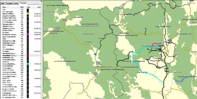
In my example I have 43 tracks (borrowed from http://www.gpsies.com/mapUser.do?username=kellerk) which would not work in the demo version but by saving them all in 1 file, the demo version of the program will work.

TracksS.jpg

It is important to save the track in .gpx format as that is the only format the program can convert.

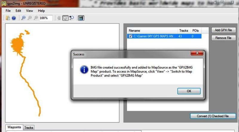
Open the program, load the file with the track and click on "Convert the checked file"

GPX2IMG readyS.jpg

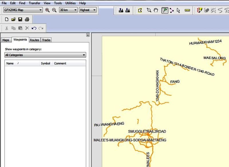
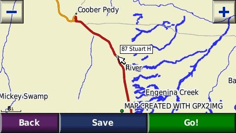
Now open Mapsource and, if nothing went wrong, your tracks will appear as a map in Mapsource.

Map in MapsourceS.jpg
 
We've got a GPS evening planned encompassing all aspects of use, including:

Which GPS
Setup
Route planning
Route saving
Route sharing
Mapsource application

.... and more.

asked around and there's a lot of interest already.
 
The GPS night sounds awesome and just what a lot of people would find interesting and need.

Sign me up. I already missed the Laos Secret War movies which I would of loved to have seen.

Lone Rider - Those posts you are penning are invaluable. Thanks heaps for documenting this process and walking us neophytes through the daunting task of GPS mapping. Greatly appreciated.
 
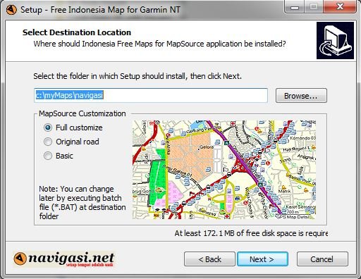
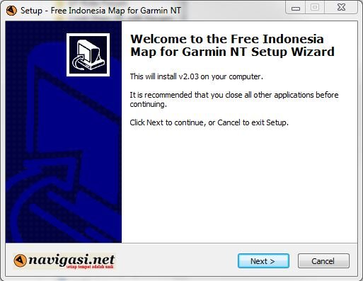
]Map Installer NavigasiNet.JPG[/attachment:1lmr50ml][/center:1lmr50ml]

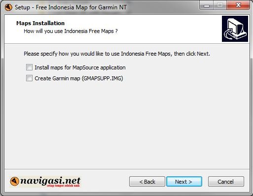
In some case you can select what you want to have: Install the map in Mapsource or prepare the map for the GPS

[center:1lmr50ml]Option NavigasiNet.JPG[/center:1lmr50ml]

Most maps have an option to have the map as a standard/original Garmin map or customized (different colors for the roads, etc.) and here you can also select where you want to have the maps copied to/installed from.

[center:1lmr50ml]Option 2 NavigasiNet.JPG[/center:1lmr50ml]

However, quite a few maps come without an installer and will require some work to get them into Mapsource. You will need GMAPTOOL and cGPSMapper which can be downloaded from here: GMAPTOOL - http://www.anpo.republika.pl/download.html#gmaptool
Free version of cGPSMapper - http://www.cgpsmapper.com/buy.htm
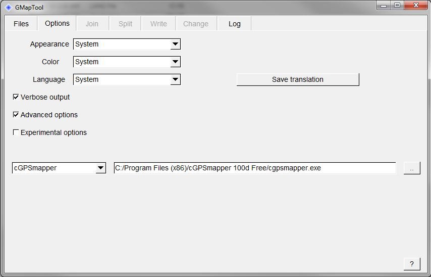
Install both programs, preferably in the same folder. Open the GMAPTOOL program and click on the OPTIONS tab. At the bottom select cGPSMapper and the location where the cGPSMapper program is stored on your computer.

[center:1lmr50ml]GMAPTOOL Options.JPG[/center:1lmr50ml]

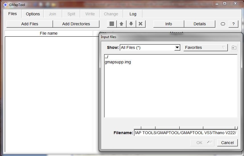
Click on the FILES tab and click on Add Files. Select the map you want to install in Mapsource - this can be as a xxxxxxxx.img (for instance 20100101.img) or as a gmapsupp.img

[center:1lmr50ml]GMAPTOOL Select Files.JPG[/center:1lmr50ml]

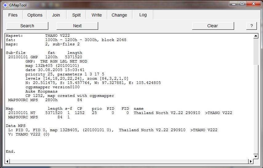
In case you want to know what type of map it is you can click on the INFO tab or the DETAILS tab. This will show the name of the map, the Family ID (FID) and the Product ID (PID), in case the map is locked, the locking code will be shown (25 characters/numerals), etc.

[center:1lmr50ml]GMAPTOOL Details.JPG[/center:1lmr50ml]

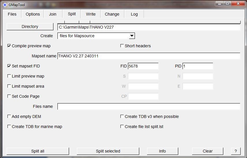
Now the real work starts: Click on the SPLIT tab and indicate the Directory/Folder where you want to create the map for Mapsource (this has to be an existing folder), select Create maps for Mapsource, tick the Compile Preview Map, Choose a name for your map, and finally type in a number for the Family ID (FID) and the Product ID (PID). You can select a number between 1 and 65535 for the FID but as Garmin is using the lower numbers for its own maps you better select a higher number. The PID normally is 1.

[center:1lmr50ml]GMAPTOOL Split.JPG[/center:1lmr50ml]

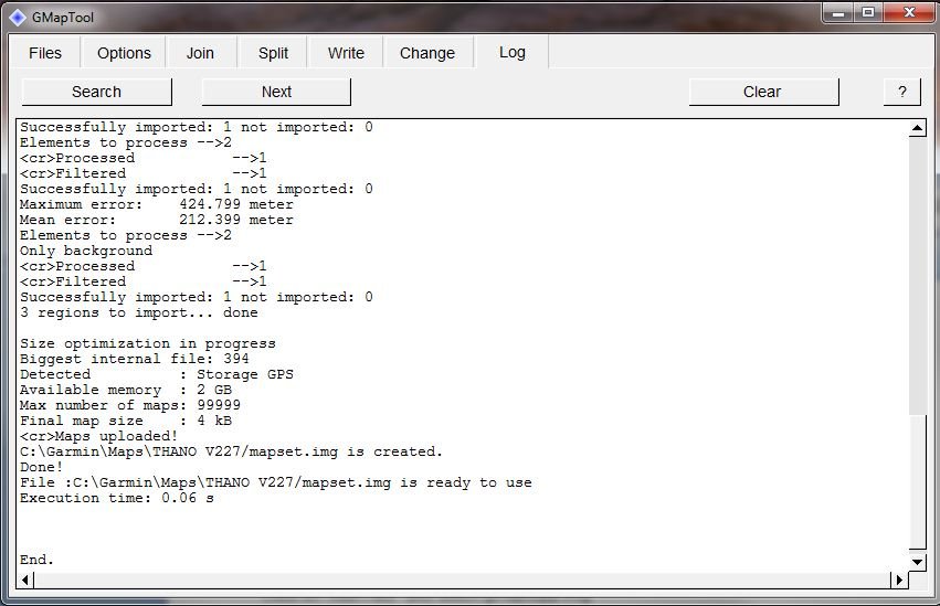
Click now on the Split All tab on the bottom and the program will now generate all the necessary files. If everything goes OK you will see something similar like, this indicating that the map has been created.

[center:1lmr50ml]GMAPTOOL File Created.JPG[/center:1lmr50ml]

You can now check in the folder you selected at the SPLIT tab if the files indeed have been generated.

[center:1lmr50ml]The files ready for Mapsource.JPG[/center:1lmr50ml]

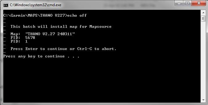
Now the final step: Click on the file INSTALL.BAT and a small black screen will pop up (the DOS command prompt)

[center:1lmr50ml]Command Prompt.JPG[/center:1lmr50ml]

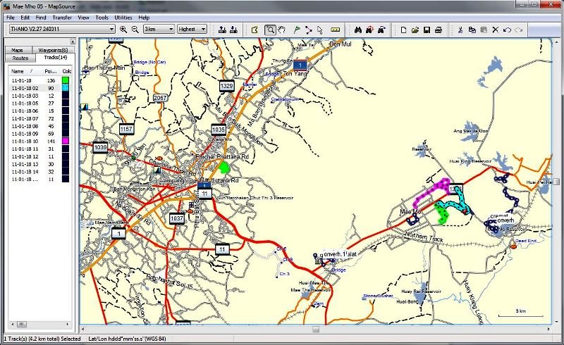
Click on ENTER when requested and once done, the map should now be in Mapsource ready to be used as shown here with the map showing Lampang and some GPS tracks at the Mae Moh mine.

[center:1lmr50ml]Map in MapsourceR.jpg[/center:1lmr50ml]

In case the map is not there or Mapsource does not want to start, you can select the UNINSTALL.BAT file and this will remove the map from Mapsource. In case you are running into problems, you can PM me.
 

Attachments

  • Map Installer NavigasiNet.JPG
    Map Installer NavigasiNet.JPG
    41.6 KB · Views: 1,528
[center:3g386mvr]Extract data from the GPS without having access to Mapsource[/center:3g386mvr]

Most Internet Cafe's do not allow the installation of programs by customers on their computers. So, when you are on the road for prolonged periods and want to back-up all your tracks and waypoints or want to include some tracks in a Trip Report while on the road, you have a potential problem.

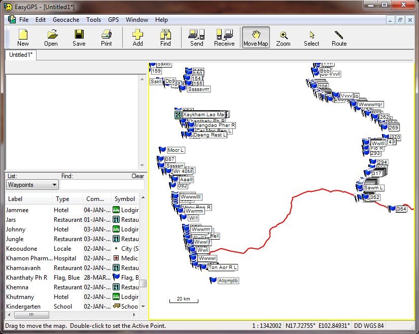
EasyGPS is a free program (http://www.easygps.com/ about 4MB) can be run from a USD Thumbdrive/Memory stick. By connecting the GPS to Easy GPS through USB ports on the computer at the Internet Cafe, you can download all the data from the GPS by clicking on the RECEIVE Tab on the top and you can then add comments, rename waypoints, etc. and save the data to the thumbdrive, send the data by email to others, etc.

[center:3g386mvr]EasyGPS Tracks and Waypoints received.JPG[/center:3g386mvr]

Setting up EasyGPS is easy - just download the program and install it on the Thumbdrive. Start EasyGPS and select the type of GPS you are going to use, use miles or kilometers, etc. and it should work without problems. Colin aka "Captain Slash" used it every evening during his last vist to Thailand to add the tracks to his daily trip report and had very few mishaps with it.
 
LR--- This easyGPS software is an excellent idea, i've always had this problem on the road and didnt think there was an answer---- nice one.
 
LR - in mapsource if i delete the track/ route, the next time I sync the GPS with mapsource set to "send data to device", will the routes be deleted from the GPS also once the sync is completed?
 
In case you have sent the routes from Mapsource to the GPS, then delete them in Mapsource and send again other routes to the device, the previously sent routes will not be deleted. You will have to delete them manually.

To delete a route in the GPS go the Route page, select the route, press Menu and one of the options you get is "Delete" - at least that is how it works in mt 60CX but it may be different on your 62S.

However, be aware that in case you send a route to the GPS, the GPS will recalculate the route and the route may be different from what you see in Mapsource. To make sure that the GPS will give the same route, you should put via points in the route to "force" the GPS to calculate the same route.
 
Lone Rider said:
In case you have sent the routes from Mapsource to the GPS, then delete them in Mapsource and send again other routes to the device, the previously sent routes will not be deleted. You will have to delete them manually.

To delete a route in the GPS go the Route page, select the route, press Menu and one of the options you get is "Delete" - at least that is how it works in mt 60CX but it may be different on your 62S.

However, be aware that in case you send a route to the GPS, the GPS will recalculate the route and the route may be different from what you see in Mapsource. To make sure that the GPS will give the same route, you should put via points in the route to "force" the GPS to calculate the same route.

was concerned about doing this! thanks LR
 
Converting tracks and waypoints formats.

Ever had a track which you would like to use but, because it is in a format your GPS or Map program can not read, you need to convert it into another format.

In order to convert tracks and waypoints from one to another format and vice-versa, you can use GPSBabel. It is a free program (donation is appreciated) and can be downloaded from here: http://www.gpsbabel.org/download.html

At http://www.gpsbabel.org/htmldoc-1.4.2/The_Formats.html you can check which formats the program can convert. These included Garmin .gdb files, Google Earth .kml files, Tom-Tom files, OziExplorer files, Microsoft Streets and Trips files and also file formats used by data loggers like Wintec Easy Showily, etc. (altogether over 160 file types)

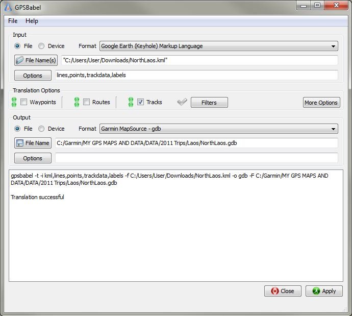
This screenshot shows a conversion from a Google Earth .kml file to a Garmin .gdb file which can be used in Garmin Mapsource.

GPSBabel.JPG

In case you want to share your files with many people, it is best to convert the tracks/waypoints to the .gpx format as this is a kind of universal format which a lot of GPS equipment and mapping programs can read.
 
I use the free Shonky Maps which are pretty basic. There are a lot of dirt roads, tracks, even main roads not on it.
If I wanted to add my tracks to the shonky base map, thus making them a permanent part of it so I can share it around with other mates & riders is there a way to do this?
We are finding & mapping new tracks/single trail all the time, so this would be a big bonus.
Cheers
 
Don't know the Shonkymaps but a quick read of what they offer I would say that you can upload both maps (the Shonkymap and the map made from your tracks) at the same time to your GPS. Assuming that the map from your tracks is "transparent" and on top of the Shonkymap, you should be able to see both maps at the same time. I am downloading now the Shonkymap and will do some testing and will let you know asap.
 
Just tested it by making a map of 1 track and a few waypoints. Combined the map with the relevant part of the Shonky map and this is the result:
[center:2w28sofr]Shonky Plus.jpg[/center:2w28sofr]

The red line is the map I created from a track with the Shonky map shown behind. Guess you know how to upload multiple maps to the GPS but just in case here is a short YouTube movie showing how to do it (source: http://www.gpsaustralia.net)


(I'm not allowed to PM or else I would send you a message directly)

I successfully followed your instructions to create a [numericalname].img file from my many off-road tracks (saved in a gpx file) using GPX2IMG. I then used GMAP to create the necessary files and ran the install.bat to put the map in MapSource. I think I did this correctly (although I seem to have lost the preciseness of the tracks - the entire combined map is only 19kb - maybe this is just how it works?).

However, when I select my newly created map and ask to send it to my GPS unit, MapSource warns me that I will overwriting data on my removable SD card (inside the GPS). Will sending this map actually overwrite my existing maps or will it just add it as an additional map? (for example, I have both the Thailand Street Map and the Thailand Topo Map on the unit now).

Also, I assume that when these multiple maps are loaded on the GPS, I am viewing them all on top of each other? Can this be done in MapSource as well or am I stuck looking at one map at a time?
 
As far as I know GPS2IMG creates all the files and installs the map automatically in Mapsource. With regard to size, my map of hiking tracks was only 65 KB while the tracks as .gpx files were over 4 MB so there is quite a bit of compression but that happens with all maps

With regard to overwriting the data on the SD card it depends on what GPS you have. All the older Garmin GPS'es normally use gmapsupp.img as filename to store the maps. The newer GPS'es (Garmin 62, 78, Oregon, etc. and probably also some of the Nuvi's) can now have different names like Thailand.img, Thailand Topo.img, etc.

In case you have an older GPS the best thing to do is to rename the existing gmapsupp.img on the SD card to something else like OLDgmapsupp.img so you won't lose it in case something goes wrong. Make a new gmapsupp.img by combining the Thailand Street Map, the Thailand Topo Map and your new map from Mapsource to the GPS (select the maps in Mapsource and click on "Send to Device").

The GPS2IMG map you made from your tracks is transparent and will show on top of the Thailand Street Map just like the Thailand Topo Map. However, in Mapsource you can not show 2 maps at the same time unless you combine them first and then split them again also with GMAPTOOL into a map for Mapsource. You will have to fiddle around with the Draw Priority paramaters as the result may not be what you would like to have as shown here where the Thailand Stree6 map blocks the other maps (combination map in Mapsource of Thailand Street Mao, my own Topo map and the map I made from .gpx tracks).

[center:2dvhwcm6]Combi Map.JPG[/center:2dvhwcm6]
 
I just installed the Rider's Corner North Thailand GPS map on my 60csx and it looks great. However, I'm seeing a light blue cross-hatch pattern over the beige parts of the map that makes it really hard to see the tracks. Can I turn this off somehow?
 
Just tried to recreate it on my 60CX but both maps are clearly visible - no light blue cross-hatch on the screen. Are you based in Chiangmai? If so, I can pop over (live just outside Chiangmai on the way to San Kampaeng) and have a look at it and maybe figure out what the cause is.

The only thing I can think of is when your own map of your tracks covers a larger area than the North Thailand offroad map. In taht case the background area where you only have your own map will be cross hatched as your own map is transparent and the tracks are very difficult if not impossible to see.
 
Will PM you. Thanks.

Also, I'm trying to combine the Rider's Corner Map and my Thai topo map. I used GmapTool to combine them into one gmapsupp.img and I copied this to the Garmin folder on my unit. I also put the *.unl file from the Rider's Corner map in the folder. When I turn on the GPS, I get a "can't unlock maps" error. Any tips?
 
How to get Garmin Mapsource Maps to show on a Mac.

Converting and Installing Garmin Mapsource maps on a Mac computer

NOTE: This will only work if you have access to a PC running MS Windows XP or later and with Mapsource and some maps installed on the PC. Make sure that the maps you want to transfer to the Mac are not locked. The Mac should have a PowerPC or Intel processor and run Mac OS 10.4 or higher.

Step 1 - Go to http://www8.garmin.com/support/download_details.jsp?id=3897 and download MapConverter for Windows (2.75 MB). This program converts maps and unlock codes on your Windows PC to the Macintosh format

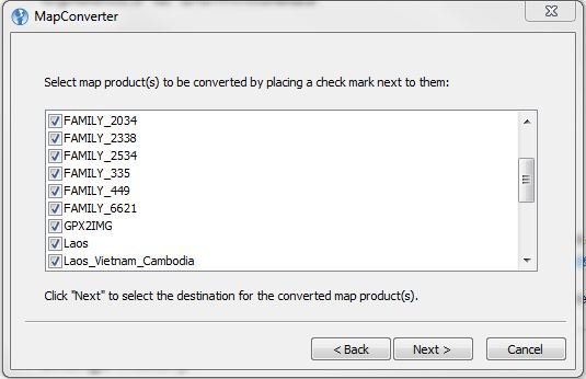
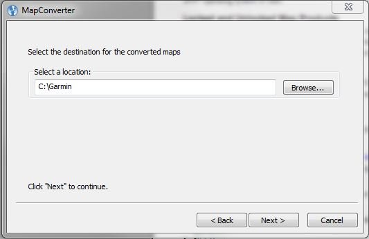
Install it on the PC and start the program. You will get a screen where you can select the maps you want to convert. Put a tick-mark in the box in front of the map name and click on NEXT. Here you can choose the location where you want to save the converted maps to - the program normally will want to save them to C:\Garmin. Click again on NEXT and the maps will be converted.

Mapconverter.JPG

Mapconverter 2.JPG

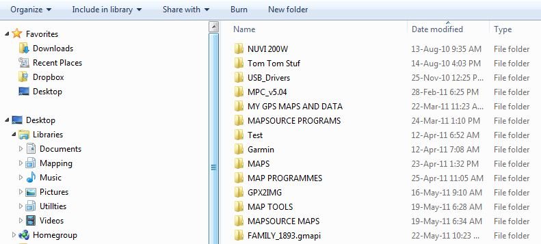
Step 2 - Copy the converted maps from the PC to the Mac. Go to http://www8.garmin.com/support/download_details.jsp?id=3825 and download Mapinstall and MapManager for the Mac (21.38 MB) and install it on the Mac following the instructions on the MapManager Web Page. MapManager will install the converted maps you have transferred to your Mac and the maps will then shown in BaseCamp http://www8.garmin.com/macosx/ or http://www8.garmin.com/support/mappingsw.jsp

Saved converted maps.JPG
Browse to the location where you have copied the converted maps to - The maps will have a Garmin map file icon and .gmapi file extension. Double click on the map file you want to install and MapManager will start and a map installation dialog box appears. Click INSTALL and that should do the trick. Repeat these steps for any other map you want to install (sorry - no pictures as I don't have a Mac).
 
Hi all

Sorry to post this here; would have prefered PM, but the board said no.

Where can I purchase a copy of the GPS maps for Laos from you LR? I can't find the site anymore....

THX
 
People sometimes ask me for GPS maps and although I do have quite a few maps I normally tell them:
Do a Google search first and, in case you can't find anything suitable for your needs, I can try to help you.

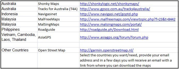
Just to help a bit, here are some URL's for websites from where you can download free GPS maps. You may have to register first on some of these sites and in at least one case you have to make a post before you can download maps.

Garmin Free Maps.JPG
 
Where can I purchase a copy of the GPS maps for Laos from you LR? I can't find the site anymore.


Cant you not make your maps available in this format (download-able)

Your maps are hard to buy....... :shock:
 
Yes, I could set it up in such a way that you can download the maps. However, as the maps are locked, I would have to know the serial number of your GPS and then load the locked map (locked to your GPS) to a place where you can download them.

At present the maps are locked to the serial number of the SD card so you can use them in any Garmin GPS which accepts SD cards so this system is more flexible for the buyer. To be honest, it is also more easy for me as I can just prepare a number of maps and give them to the seller while the other way (downloadable) I have to prepare each map separately and as I travel quite often, the process may take quite some time.

Anyway, you can buy my Laos GPS map from Eagle GPS in Chiangmai - http://eaglegps.co.th/index.php/lang-th/products/maps while the North Thailand GPS map is being sold by Phil.
 
Thanks Lr, I looked it up and there is a paypal method of paying, the person I spoke to was on the ball and quick to reply...... :D

The postage costs to the UK..

Laos Map – 1.760 + shipping 1.600 = TOTAL 3.360 THB

Nearly as much as the map....

So I'll get one picked and bought home to me as I'm not in a rush....

Looking forward to planning my Insertion.. :p
 
I need some help loading maps in to my Garmin Zumo GPS from Open Street Map.
I was able to do it ok with my old computer with Map Source loaded on it
But I am trying it from a new computer now and it is not working.
I downloaded the exc files from OSM to my computer but they don't show up on the new Mapsource I downloaded from the internet on to this new computer.
The funny thing is that I was actually successful with the first map of Thailand I did but when I tried to load Vietnam and Malaysia, they wouldn't load in to MapSource. I then erased Thailand to see if Vietnam would load and it would NOT. So now nothing will load in to MapSource.
Then I tried to load the gmapsupp-zip file directly in to my Zumo GPS but I can't figure out how to cut and paste the WinRAR files. It would not allow me to "copy" the file. And I don't think I can just copy the zip file without unzipping it first
I am using JaVaWa to rename the files first before it goes to MapSource.......at least that is the way it was working for me before.
Any suggestions??? And if you do, I am not real sharp when it comes to computers so talk real sloooooooooow for me :)
 
Back
Top Bottom