Luang Prabang to Vientiane, Oct 21-24

mikehohman

Senior Member
Joined
Aug 20, 2011
Bikes
KLX250
2 friends and I rode through northern Laos last weekend, like this:

Day 1, Friday, Oct 21: Bangkok to LPQ on Bangkok Airways, pickup the bikes by noon, lunch, and in Nong Kiau by Happy Hour.
Day 2, Saturday: Nong Kiau to Phonsavan.
Day 3, Sunday: Phonsavan to Muang Huang, by way of Muang Moc and early, aborted detour towards Long Cheng.
Day 4, Monday: Muang Huang to Vientaine by way of Xiang Mai, arriving about 6:00 PM, 9:45 PM Thai flight back to BKK, in the office Tuesday...

What a stunningly beautiful country. Each day was better than the last, and it started out pretty damn good. Nong Kiau is spectacular, as is much of 1-C to Phonsavan. On Saturday, my friends insisted on making a half-hearted attempt to Long Cheng, but we didn't get far before being turned back by young men with AK47s. The detour led to some excellent trails south of Phonsavan which were a blast to ride. The ride over the mountains from Phonsavan to Muang Moc is out of this world beautiful, as are the valleys, and south of Muang Moc the terrain changes to jungle. Overnighted at the Keomany Guesthouse in Muang Huang and then due west through hills and valleys and on the Vientiane. This last day was the best pure riding of the trip, some great single track, plenty of water, lots of mud, and dragging the bikes overs trees.

Conditions were great! Beautiful clear blue skies, brisk chilly mornings, crisp mountain air, and dry dirt roads (except for 1 section the last day). Can't wait to go back. Thanks to Jim at Remote Asia Travel for the bikes and this forum for route planning tips. A few photos:

Map of Trip
Screen%252520Shot%2525202011-10-29%252520at%2525203.21.31%252520PM.jpg


Mekong River north of LPQ
_1050456.JPG


Valley of the Lao
_1050459.JPG


Golden Rice
_1050468.JPG


Nong Kiau
_1050499.JPG


Nong Kiau
_1050502.JPG


Northern Road to Long Cheng
_1050555.JPG


Boy in the Valley
_1050536.JPG


Valley on the way to Long Cheng. I made it past the checkpoint, but my friend was stopped down below.
_1050554.JPG


Terraces and village north of Muang Moc
_1050602.JPG


Sala with a View
_1050608.JPG


On the trail, Day 4
_1050637.JPG


Local man in the Jungle
_1050654.JPG


Stream crossing
20111023-IMG_0170.JPG


Ferry
_1050666.JPG


Waiting for the Ferry
_1050669.JPG


Crossing
_1050680.JPG


Broadcast Rice
_1050711.JPG


Rice ready for harvest
_1050724.JPG
 
Thanks for the beautiful pictures. Really amazed that most of the tracks were quite dry. The track from Muang Moc to Thasi and from Muang Hiang to Xiang Mee can be quite muddy right after the rainy season.

Long Chieng is off limits and even if you guys had made it past the checkpoint at the river where your friend was stopped you most probably would not have made it into Long Chieng as there are more checkpoints along the way. Robert Hiekel made it up to about a kilometer before Long Chieng a few years back but had to return to Phonsavan as the army would not let him through eventhough it was less than 2 kilometers to the checkpoint on the southern side from where he would have been able to go to Vientiane.
 
Great report and photo's Mike, glad to see that planned trip came off. I presume the photo's are with your new Canon S100? the greens are captured perfectly, look very realistic.


Really enjoyed the report, great area you were riding in, hope to be there in a couple of weeks
 
I was surprised how dry it was. Jim told us NOT to try the dirt trail from Vang Thong to Phonsavan, as it would be too muddy and the rivers uncrossable, but not sure now. The road from Muang Moc on to Thasi has some big ruts, but it was all dried out. The only wet was between Muang Huang and the ferry. This was actually quite wet, and the trail was covered with moss, it was damn slippery. The tree that guy is sitting on had also fallen across the trail, and we had to drag the bikes around the stump, it was pretty hard. Have some video of that will share when i get a chance. After the ferry the double track was completely dry and really allowed for some serious speed...

Pix are with my Lumix GH2. I've been tweaking the color and white balance settings and i've finally got some i like. I have always had to process the raws in Lightroom, but these are all JPEG right out of the camera. Very happy with that. The S100 isn't out for another month I think, but looking forward to that.

I knew we had zero chance getting in LS20, but my friends wanted to try, and the road in is really beautiful anyway. Like you say, glad we got turned around when we did. According to Jim's wife back in Vientiane, the current 'fine' for going is US$2,000, but that seems extreme.

Phil, have a great trip!! It's the perfect time of year to go, before they cut all that lovely rice.

Enjoy!

Mike
 
Mike - Did you take your Garmin Montana 600?

The reason I ask is I took mine on the dirt trails to Shane State in the last couple of days & in rough terrain there was an intermittent power related problem even with the power source being the 12V DC from the battery.

I think it is due to the Garmin re-chargeable battery having a weak friction hold on its power connections and going open circuit in bigger vibrations on dirt trails, I will retest it with some AA batteries instead and see if this solves the problem. Also I will tighten the locking screw on the GPS holder to see if this adds a tighter hold.
 
KTMphil said:
Mike - Did you take your Garmin Montana 600?

The reason I ask is I took mine on the dirt trails to Shane State in the last couple of days & in rough terrain there was an intermittent power related problem even with the power source being the 12V DC from the battery.

I think it is due to the Garmin re-chargeable battery having a weak friction hold on its power connections and going open circuit in bigger vibrations on dirt trails, I will retest it with some AA batteries instead and see if this solves the problem. Also I will tighten the locking screw on the GPS holder to see if this adds a tighter hold.

Not sure if this is a battery issue as with the older GPS'es the batteries are bypassed when you use external power but this may have changed with the Montana. With the older GPS'es, in case you were using battery power, it helped to put a piece of rubber in between the battery and the battery cover so that the battery was kept better in place.
 
I'll give the rubber jamming trick a try, thx LR.


Lone Rider said:
KTMphil said:
Mike - Did you take your Garmin Montana 600?

The reason I ask is I took mine on the dirt trails to Shane State in the last couple of days & in rough terrain there was an intermittent power related problem even with the power source being the 12V DC from the battery.

I think it is due to the Garmin re-chargeable battery having a weak friction hold on its power connections and going open circuit in bigger vibrations on dirt trails, I will retest it with some AA batteries instead and see if this solves the problem. Also I will tighten the locking screw on the GPS holder to see if this adds a tighter hold.

Not sure if this is a battery issue as with the older GPS'es the batteries are bypassed when you use external power but this may have changed with the Montana. With the older GPS'es, in case you were using battery power, it helped to put a piece of rubber in between the battery and the battery cover so that the battery was kept better in place.
 
Mike,
* Envy producing report, color me green!

** Real sweet, Clicks!

* I am just off the Northeastern Train 69 Bangkok-Nongkhai.
Home sweet home, and Kow Neow!

Plugged in the Dell U2410 Ultrasharp 24" monitor. (The other half of the equation) to view your ride.

The first reports from Taxi drivers here in Vientiane, not a drop of rain since I departed almost 3 weeks!

Well it looks like you did in 4 days, what it would take me 14 to complete! (I - no job. )
Phonsavon
Phil the gang and I, did the ride South from Phonsavan to Nam Siam Checkpoint. I think this is a great ride, with the intention of a turnaround at the checkpoint. (recommend). Stunning views and no security concerns. Nam Siam villagers very friendly. (Never heard of a fine, but if I was renting bikes that’s what I would say!)

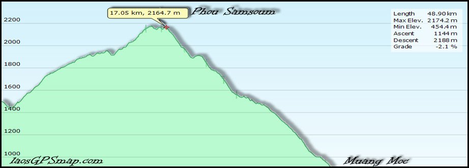
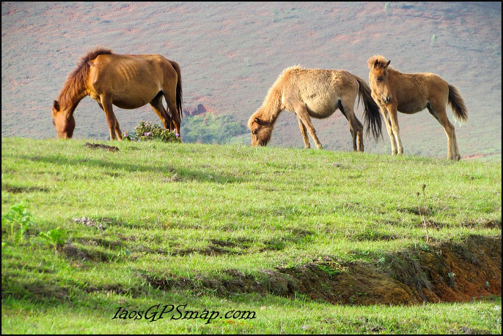
M Khoun-Muang Moc Road (3908) is fantastic ride for a 10 meter wide road! Great views grassy plains (little Mongolia) and you pass The second highest elevation in Laos , (on a road). 2173 meters.( Near Phou Samsoum, 2620 meters) a long downhill to the Moc (Fog) valley at 497 meters. - Of course the ride is so stunning, who is looking at the elevation readout on the GPS!!.

elevation-profile.jpg

This last season we have discovered some great trail riding and loops in this area. Secret war, landing sites and remote Jar sites! Ready for the next LaosGPSmap, update. Why would anyone want to go to Long Cheng, and associated unfriendlyness/*&%*

horses.jpg

Great pics I wish I could afford a camera like that buttttt. I am on my 3rd one for this year. Dropped, lost, died.... for this reason $600 is top price for me!

Ohh yea that sweet slippery section its only 12 k's that ends at the Nam Ngiap. Ask Phill about that one he camped in the bamboo tunnel there!
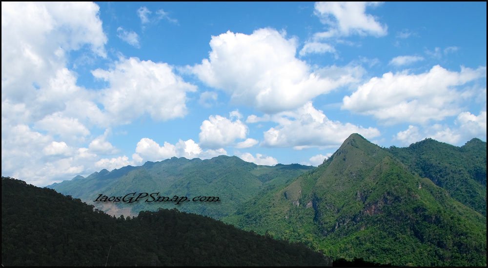
mountains.jpg


Interesting that you got a Mono ferry (Canoe)? Usually there are a couple catamarans with planks between that they pull across with a rope.

Thanks for the great report.
I will pm you to find out how the map and GPS worked for you...

Midnitemapper
 
Mike

You said: "... I knew we had zero chance getting in LS20, but my friends wanted to try, ..."

FYI, re Long Tieng, it's "LS-30" or "LS-98" as listed in the AirAm site book, or "LS-20A" as it was commonly known as, but not listed as such. "LS-20" is Sam Thong, about 45 minutes drive further north, the former USAID base, up to February-March 1970.

Mac
 
Thanks for the heads up Mac. I read "The Ravens" a few years ago and didn't quite remember. Meanwhile, I just started "Shooting at the Moon", what a great story. I heard there is another book too, first-hand accounts about the fall of Long Cheng. Can't remember the name, but also supposed to be good.

Midnight, thanks for the kinds words. I think you are right about Long Cheng.Why go, if the people are not friendly, and there is so much to see elsewhere in Laos anyway? The ride into Nam Siam valley is great as it is. And we had a GREAT time taking some rural double-track thru the rolling hills to get back to the tarmac road south out of Phonsavan. And 3908, I didn't believe I was in Laos, I thought I was in Switzerland for a bit. It was surreal. And that descent is nuts, i thought it would NEVER end... and when it does, you roll up on Moc Valley. What a reward...

I am definitely ready for the next version of your map. Let me say that the version I had was awesome. We didn't have much of a plan, so it was incredibly useful to have it. Also, we left the Moc Valley about 4:00 PM and got to Muang Huang after dark with NO IDEA where to stay. So, i just pulled up the Map, hit Find Lodging, and it led me straight to the Keomany. Well, the Marriott it's not, but we were very happy to find it glad not to have to push on to Paksan. And the owner's (adult) daughter is very easy on the eyes...

As to the Montana, well, on the one hand, it is fantastic. Everything we've been waiting for in a GPS. However, Phil, I too had intermittent power failures. WHAT A PAIN! It was fine until the last day, but after the ferry, the unit kept resetting about every 5 minutes. Was able to find our way to Vientaine ok, but still... I was using the rechargeable battery that came with the unit. I hope this was a rare occurrence, but fear that this experience will be typical. Shit.

Ok, then. Phil, what about the Bamboo Tunnel at Nam Ngiap ... :)
 
I'm pretty sure it's due to the loose fitting Garmin rechargable battery, i will test it again in 2 days.


Bamboo tunnel ---we ended up sleeping there (see below)

file.php


The ferry across that river was a catamaran when we crossed 7 months ago

file.php


mikehohman said:
As to the Montana, well, on the one hand, it is fantastic. Everything we've been waiting for in a GPS. However, Phil, I too had intermittent power failures. WHAT A PAIN! It was fine until the last day, but after the ferry, the unit kept resetting about every 5 minutes. Was able to find our way to Vientaine ok, but still... I was using the rechargeable battery that came with the unit. I hope this was a rare occurrence, but fear that this experience will be typical. Shit.

Ok, then. Phil, what about the Bamboo Tunnel at Nam Ngiap ... :)
 
Mike

If you liked the RAVENS, you might also want to read his book on AIR AMERICA, both available at ASIA BOOKS and I think I saw it at Monument in Vientiane earlier this month.

Roger Warner, author of SHOOTING AT THE MOON, is a friend. Only "problem" I have with his book is that it's somewhat limited in scope, doesn't cover the entirety of the war in Laos. He was over here August 2008 and asked to tag along with Sunee & I on one of our trips, that one we spent the night on the floor of of the nice family who run the good Pho shop in Long Tieng, blankets and mossie nets, of course, and her TV with Thai soaps so Sunee was happy. Six months later electricity and cell phone service arrived at LT!

Here's some other books of possible interest.

Mac

Great "oral history" of the air evac of Long Tieng and the fall out, May-August or so, 1975

Sky Is Falling: An Oral History of the CIA's Evacuation of the Hmong from Laos by Gayle L. Morrison

Starting in 1960, Hmong guerrilla soldiers, under the command of General Vang Pao, functioned as the hands and feet of the U.S. Central Intelligence Agency's secret war against communist forces in Laos. Operating out of Long Cheng, the Hmong soldiers allowed the CIA to accomplish two objectives: to maintain the perception of United States neutrality in Laos and to tie up North Vietnamese troops in Laos who would otherwise have been sent to fight in South Vietnam. The U.S. government had quietly pledged to General Vang Pao and the Hmong that the Americans would take care of them in the event that Laos fell. In May 1975, this promise was redeemed when the CIA generated an air evacuation that moved more than 2,500 Hmong officers, soldiers and family members out of their mountain-ringed airbase. Fifty or so Hmong and Americans involved in the evacuation provide herein a firsthand account of the 14-day evacuation and the events leading up to it. 220 pages.

xxxxxxxxxxxxxxxxxxxxxxxxxxxxxxxxxxxxxxxxxxxxxxxx

A really boring read, if only because of the extreme details. Covers the entire war north to south. I keep this one handy for reference.

Shadow War: The CIA's Secret War in Laos by Ken Conboy

453 pages, index, glossary, maps, black & white photographs. This is the first comprehensive account of the CIA's largest paramilitary operation of the cold war period. This authoritative history took 10 years to compile and involved more than 650 interviews with CIA case officers; U.S. military officials; and senior Lao, Thai and North Vietnamese officers, as well as thousands of pages of declassified government documents.

xxxxxxxxxxxxxxxxxxxxxxxxxxxxxxxxxxxxxxxxxxxxxxxxxxxxx

Good one here, 500+ pages, and FREE to download. Lost my hardcopy in the flood, will have to have it printed out again.

http://www.gwu.edu/~nsarchiv/NSAEBB/NSA ... ARMIES.pdf

In what is by far the longest of the CIA histories, Thomas Ahern takes on the ambitious task of examining the front of the Southeast Asian conflict where the CIA waged its own war, a full-service operation in which it served as the main action agency while also supplying its standard covert action and political warfare efforts. The study details the inception and progress of the array of tribal secret armies the CIA recruited in Laos, most prominently that of the Hmong tribe, whose military leader was General Vang Pao. While, in general, this volume is long on combat action it nevertheless passes quickly over certain key events, such as the specific Hmong role in the resumption of the Laotian war in 1963; and the key tipping point of Operation "Triangle," in the summer of 1964, when the U.S. cast off the Geneva restraints. Other important military events of the 1969-1971 period, declassified elsewhere, are shrouded in secrecy here by censors' redactions. The book is best read in conjunction with the Air Force official history of the war in northern Laos, declassified through the Archive's law suit against that agency and which the Archive posted in April 2008. (see below) This CIA history is also circumspect on relations within the U.S. embassy, on those between agency managers in Vientiane and in Thailand, on those between the CIA and U.S. Air Force, on the CIA's management of Air America, on the operation of the CIA base at Long Tieng, and on political action in the Laotian twin capitals. The role of Thailand in the CIA war is represented here largely by deleted material even though this has been declassified. Among the highlights of this CIA history is the coverage of drug trafficking in Laos [pp. 535-548], and the treatment of missions into North Vietnam mounted from Laos during 1970-1972 [pp. 349-372].

http://www.gwu.edu/~nsarchiv/NSAEBB/NSAEBB248/

xxxxxxxxxxxxxxxxxxxxxxxxxxxxxxxxxxxxxxxxxxxxxxxxxxxxxxxxx

More of a fun read here by Howie Lewin:

http://www.customwooddesign.com/sunsets ... ers-2.html

Sunsets, Bulldozers, and Elephants: Twelve Years in Laos,
The Stories I Never Told

Note: Two reviews of the book at the url.

I've seen the book at Monument Books in Vientiane.

xxxxxxxxxxxxxxxxxxxxxxxxxxxxxxxxxxxxxxxxxxxxxxxxxxxxxxxxxxxxxxx
 
Mike -

Re the Garmin Montana 600 series intermittent power problem, I added some soft plastic to the back end of the Garmin battery, creating a strong friction hold on the battery contacts and did up the safety retaining screw.

I took it for a hard ride today, didn't have a single power problem, looks like that solves it, it's the same problem the Garmin 60 csx's had re intermittent power.
 
A couple of 3D maps Midnight Mapper put together of the trail route south of Phonsavan, will be great when I can get them in 3D like this on the Garmin Montana 600 series.


Phonsavan to Thasi

Thasi-Phonsavan-Route[2].jpg
Map Copyright ©www.laosGPSmap.com - Permission to copy required


Thasi-Thathom-M-Khoun

Thasi-Thathom-M-Khoun[3].jpg
Map Copyright ©www.laosGPSmap.com - Permission to copy required


Thasi to Vientiane

Vte-BThasi-Route[2].jpg
Map Copyright ©www.laosGPSmap.com - Permission to copy required
 
Thanks cuban8!

Midnight Mapper, the map is really coming along, looking forward to it..
 
How 3 idiots get around a giant tree across the trail. Between Muang Huong and Vang Naxay...
[VIDEO]http://vimeo.com/31669437[/VIDEO]


Mike
 
I guess not. It must have been removed by the time we got there. The huge tree across trail was the only real obstacle, other than vines and stuff that liked to grab you and pull you down.

Mike
 
Hey Phil, any photos you can share of your successful battery compartment engineering? Thanks?


KTMphil said:
Mike -

Re the Garmin Montana 600 series intermittent power problem, I added some soft plastic to the back end of the Garmin battery, creating a strong friction hold on the battery contacts and did up the safety retaining screw.

I took it for a hard ride today, didn't have a single power problem, looks like that solves it, it's the same problem the Garmin 60 csx's had re intermittent power.
 
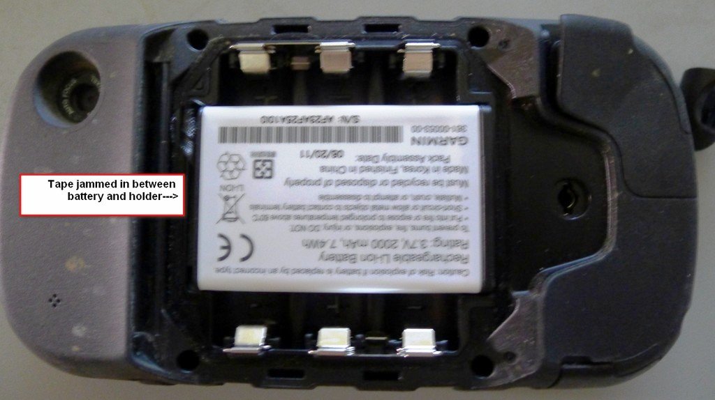
Mike i Jammed some self-amalgamating tape between the battery holder and the battery (opposite end to the battery connections) and it has done the job so far. 2 trail rides and no power interruptions.

Use something rubbery and soft (maybe a cut piece of dish washing glove or similar) and you'll get a better friction hold for the battery against the power contacts.


montana battery fix.jpg


mikehohman said:
Hey Phil, any photos you can share of your successful battery compartment engineering? Thanks?


KTMphil said:
Mike -

Re the Garmin Montana 600 series intermittent power problem, I added some soft plastic to the back end of the Garmin battery, creating a strong friction hold on the battery contacts and did up the safety retaining screw.

I took it for a hard ride today, didn't have a single power problem, looks like that solves it, it's the same problem the Garmin 60 csx's had re intermittent power.
 
Thanks Phil! On my trip to Nan last weekend, i wrapped a Fisherman's Friend wrapper around the back end of the battery and voila! No more problems... Nice...

Mike
 
MM just has a piece of foam on top of the battery to create a friction hold on the battery that seems to work.


mikehohman said:
Thanks Phil! On my trip to Nan last weekend, i wrapped a Fisherman's Friend wrapper around the back end of the battery and voila! No more problems... Nice...

Mike
 
Back
Top Bottom