Another Mapping Trip to Laos

Lone Rider

Blokes Who Can
Joined
Jan 29, 2011
Location
Chiangmai
Bikes
4 Wheels
Another Mapping Trip to Central Laos - Part 1

Map showing the routes taken
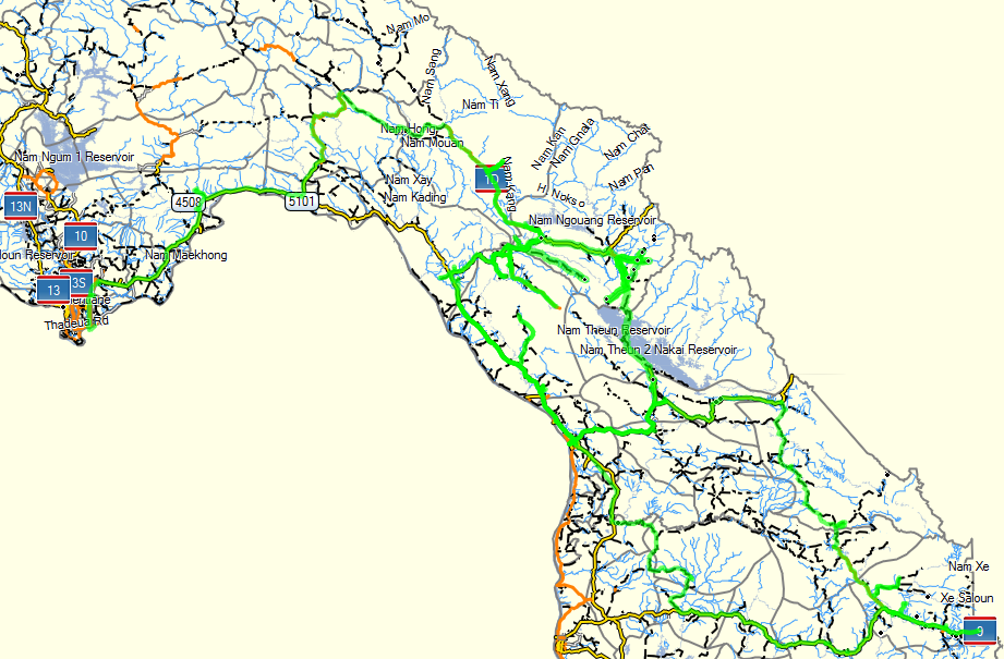
Laos Mapping Trip March 2013.PNG

On my way to Laos I took the same road where last year I saw a lot of birds in the rice fields and this time again there were quite a few of them - difficult to take a picture as they would fly off once I pointed the camera in their direction.
IMG_3871.jpg


IMG_3872.jpg


The haze was already quite bad along my route
IMG_3874.jpg


Early morning crossing the Friendship Bridge between Nongkhai and Vientiane
IMG_3875.jpg


The Laos part of the trip started in Vientiane but as it was very early when I crossed the border from Nongkhai to Vientiane, the people I was planning to meet had not yet shown up in their offices so I decided to proceed with my itinerary for the day - Vientiane, Pakxane, Thasi to Viengthong and Rd 8.

Lots of building activities going on around Vientiane
IMG_3878.jpg


Besides housing and industrial estates, there is also a lot of other construction work going on - here a new road and bridge are being constructed through a National Protected Area
IMG_3881.jpg


IMG_3882.jpg


While driving along it seems that Laos has big plans as at a place where I had expected to find a narrow unpaved track, I blundered into the construction of a new highway complete with a bypass around the village
IMG_3949.jpg


IMG_3947.jpg


On the way to Thasi I found this cement truck lying along the road - not sure what happened but it looks like that the brakes failed as there were no brake marks on the road.
IMG_3886.jpg

IMG_3887.jpg


Road 1D from Phonsavan via Thasi, Viengthong and on to Rd 8 is now completely paved. There were 2 bridges which were not yet completed but I guess that before the rainy season starts, they may be finished as well
IMG_3889.jpg


IMG_3891.jpg


IMG_3890.jpg


IMG_3893.jpg


Sunset on Rd 1D near the Nam Ngouang (Youang) Hydropower project
IMG_3898.jpg

IMG_3899.jpg


I stayed the night at the Sai Nam Hai Resort. The first look is not very positive as you look at the backside of the resort from the main road but once you drive in you will find a nice place with small individual bungalows, good Western and Lao food and very friendly people who speak good English.
IMG_3904.jpg


As the day before it was to late to have a look at the Nam Ngouang Hydropower Project, I back-tracked a bit on Rd 1D. On my way to the turnoff I found this Vietnamese trailer truck which apparently had similar brake problems as his Lao counterpart the day before
IMG_3907.jpg


IMG_3910.jpg


IMG_3926.jpg


The Nam Ngouang Dam and Power Station
IMG_3911.jpg


The Nam Ngouang Reservoir
IMG_3923.jpg


IMG_3918.jpg


IMG_3924.jpg


Boats in the Nam Theun river made from war scrap (auxilary fuel tanks from planes dropped during the Vietnam war I guess)
IMG_3928.jpg


IMG_3909.jpg
 
Last edited:
Wow, things are happening so quickly in Laos.
Yen, yen, yen.

Enjoying your pics Auke.
 
Another Mapping Trip to Central Laos - Part 2

After the Nam Ngouang Reservoir I had some terrain to cover to reach Thakheak which would be my next overnight stop. Along the road I met quite a few young people doing "the Loop" (Thakaek to Thakeak via the Nam Theun Reservoir and Konglor cave) on rented motorbikes and everytime I am amazed at "how" they ride. Saw an accident site with the bike having hardly a scratch but with the young girl just being transported to the closest hospital with a bad case of road rash (sorry, no picture). Here are a few pictures taken on this particular ride:

Young lady on a classic. Guitar protected with plastic, mouth and nose covered with a cloth against the dust but with the helmet hanging on the backside of the bike in front of the brake light.
LadeonBike2.png


Oh, it is so hot and anyway it is "cool" to ride without a shirt
Ohsocool.png


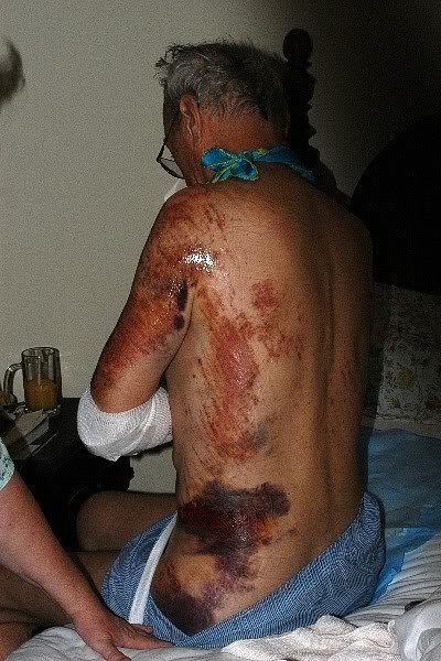
Showed them this picture but they were not impressed - "It is so hot man and don't worry, we won't have an accident as we are careful".
Road Rash wearing T shirt and Jeans.jpg
And this is what this guy had to say about his accident: For those of you who may be on the fence regarding to wear or not to wear, consider your self in the condition pictured above. This as a result of sliding in T shirt & jeans. That elbow was ground down to the bone. I have posted this picture before, and was roundly criticized by some who thought it was too graphic and inflammatory. Too bad. This could be you and I can tell you that when you are lying on the gurney in the trauma center and a med tech is scrubbing the debris from your wounds with soapy antiseptic and a toothbrush while you are shaking from the pain, you will become a believer as I have. So I consider this message a public service, and will continue to post the picture occasionally for the benefit of the newbie's.

Mind you, the conditions in the Lao hospitals are a far cry what you will find in hospitals in Thailand or in the Western world - forget about pain killers and other stuf. OK, Rant Over and back to my trip

Happy kids on the bridge although they found it a bit scary with the big white guy taking pictures of them
IMG_3930.jpg


Colors in the ricefields
IMG_3937.jpg

IMG_4056.jpg


Making way for rubber?
IMG_3938.jpg


It is amazing to see the high tension power pylon building crews driving up these steep slopes
IMG_4064.jpg


Not sure how this Malaysian Road Name sign ended up here
IMG_3950.jpg


The old road on the left replaced by the new improved road on the right
IMG_3951.jpg


Trying to find my way through the ricefieds with all kinds of tracks branching off to left and right
IMG_3952.jpg


Finally back on Road 9 from Savannakhet to the border with Vietnam
IMG_3957.jpg


Oops, running out of paint while painting the rooms in the Guesthouse in Xepon
IMG_3958.jpg


Remains of the old Wat riddled with bulletholes in Xepon town (Xepon Kao)
IMG_3959.jpg

IMG_3960.jpg


This is what was left over of the bank in Xepon Kao after the war - an empty vault
IMG_3961.jpg


The Museum commemorating the Lam Son battle on Road 9 is now finally finished but you still have to chase someone to come and open the gate and the museum. There is a fading piece of paper on the gate with several telephone numbers but all to no avail. Finally someone in the shop next to the museum gave me this number 020-95566124 and this connected to a very nice young and friendly lady who spoke excellent English and she had the keys to open the gate and the museum

IMG_4015.jpg

IMG_3965.jpg


In front of the museum
IMG_4013.jpg

IMG_4011.jpg

IMG_4010.jpg

IMG_4006.jpg


Scrap outside the museum
IMG_4007.jpg

IMG_4008.jpg


Inside the Museum - Maps of the Ho Chi Minh Trail
IMG_4003.jpg

IMG_3981.jpg

IMG_3973.jpg


Transport along the Ho Chi Minh Trail US style
IMG_3980.jpg

IMG_3978.jpg

IMG_3985.jpg


Transport along the Ho Chi Minh Trail Vietnam style
IMG_3979.jpg

IMG_3983.jpg

IMG_3986.jpg

IMG_3987.jpg


Assorted Weaponry
IMG_3995.jpg

IMG_3988.jpg

IMG_3989.jpg


There is quite a bit more so if you are a history buff, headover to the Museum (entry fee 10,000 Kip or about 1.25 USD) and by the way Mac, is this what you are looking for?
IMG_4000.jpg


I love these Chinese signs leading to their project sites but I am not always sure what they want to say. Found out that this sign "Run in Yunan China Source Water Color Classes Hang Power Station Site" leads to a hydro power project and by the way, I was not welcome here as they quicly blocked the road with two trucks when they saw me coming in my old truck
IMG_4016.jpg


Lovely and very quiet area and in the distance you can see the road hacked out of the forest leading to the project site
IMG_4017.jpg

IMG_4018.jpg


Not sure what happens here but found a lot of new machinery for a pulp/paper mill lying in the open in Xepon with part of the equipment stored at the District Office and the Police/Security office.
IMG_4023.jpg

IMG_4022.jpg


Happy Vietnamese scrap dealer on his bike with his catch of the day - an old motorbike - hanging on the back side with all kinds of other metal scrap leaving very little space for himself
IMG_4025.jpg

IMG_4024.jpg


One of the ferries which you see from time to time in Laos along the way but quite a few have already been or will be replaced by bridges
IMG_3945.jpg


Sunset in Vilaboury
IMG_4027.jpg

IMG_4026.jpg


Early morning on the Ho Chi Minh trail - here on my way to the Laboy Ford with the road being upgraded to a 7 meter wide road and electric power brought in
IMG_4029.jpg

IMG_4030.jpg


Bridge on the Ho Chi Minh trail
IMG_4032.jpg


River crossing which which will disappear soon as the construction company is bringing in their equipment to build the new bridge
IMG_4033.jpg


Party time with the guys being on their way to the Wat
IMG_4035.jpg

IMG_4037.jpg

IMG_4038.jpg

IMG_4039.jpg

IMG_4040.jpg


Crossing the Nam Ngo on my way to Ban Phanop (Vang Khon) which has quite a bit of war scrap "on show"
IMG_4051.jpg


IMG_4042.jpg

IMG_4043.jpg

IMG_4045.jpg


Water container made out of aluminum war scrap
IMG_4047.jpg


IMG_4044.jpg

IMG_4050.jpg

IMG_4048.jpg


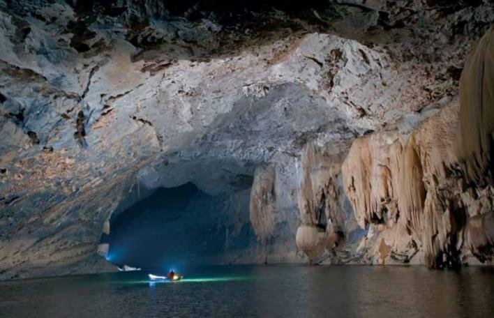
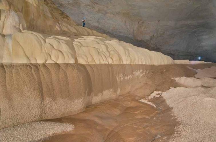
Sign for the Xe Bang Fai Cave (Tham Khoun Xe also known as the Nam Lode Cave) near Ban Nongping east of Bualapha - was not aware that it was now open for tourists as a few years ago you would need to have written approval from the authorities before you could enter the cave
IMG_4053.jpg


Just to wet your appetite a bit for this magnificent cave, here are two pictures taken from the NSS News magazine of July 2009 http://www.caves.org/pub/nssnews/july09_nssnews.pdf where you can find more info on the cave and its location

XBF Cave 1.jpgXBF 2.jpg
 
That road rash is nasty

Apologies to throw that picture in early morning but seeing these guys and gals riding around in Laos only wearing shorts, tank-tops and flip flops makes me a bit upset as they have no clue what the consequences can be in case they get into an accident (and believe me I have seen quite a few accidents in Laos with plenty of road rash and other injuries)
 
So glad i join this site. What a wealth of information . Here's hoping i can continune the HCM trail on the Laos side .. it looks less paved than the Vietnam side . that was a beautiful ride through the national park but unfortunatl was missing scrap parts laying around . Thank you for these photos .
 
Great report, as always, and thanks Auke. The changes are massive from just 3 years ago when I went through that region.
 
Great report, as always, and thanks Auke. The changes are massive from just 3 years ago when I went through that region.

Actually, the report was posted 2 1/2 years ago.
Well worth revisiting though.

LR, re the Thakeak Loop, is that fully paved now ?
I did it in 2006 and it was full of haul trucks for the dam project. Dustiest ride I've ever had.
Another route I did back then was Phonsavan to Pakxan which was dirt at the time and stunning scenery through the mountains. Also interested to know if thats paved now.
I'll be up that way in the new year on a sports tourer, so trying to stick to sealed roads.

Wow. Missed that... so the change in some areas in six months was massive! The narrow tracks, turned into highways in no time flat.

The museum certainly progressed in just a few months too. I got booted out, as they were still working on it.

 
Actually, the report was posted 2 1/2 years ago.
Well worth revisiting though.

LR, re the Thakeak Loop, is that fully paved now ?
I did it in 2006 and it was full of haul trucks for the dam project. Dustiest ride I've ever had.
Another route I did back then was Phonsavan to Pakxan which was dirt at the time and stunning scenery through the mountains. Also interested to know if thats paved now.
I'll be up that way in the new year on a sports tourer, so trying to stick to sealed roads.

Bill Have a look here for the Thakhaek Loop: Road 1E This was year ago so the last part(s) might now have been upgraded/paved.

Road 1D from Phonsavan to Ban Pakha at Rd 8 is fully paved. About halfway at Thasi to can take the turnoff to the south-west (Rd 5001) which brings you to Pakxane - all paved although there are many places where the road was badly potholed.
 
Re the Phonsavanh to Paksane road:

-- All new, well, semi, 2 years now, nice, from Moung Khoun to where you hit the flats a bit north of Tha Vieng.

-- Good old road Tha Vieng to Thasy, including the two newish bridges, about 2 years old.

-- Thasy west to Moung Hueang, not so good, dusty, sort of rough but no big holes, 45-60 minutes in a 4-wheeler.

-- Moung Hueang to Paksane, good old road.

I was down this road in mid-November.

Mac
 
LR, Mactbkk
Thx for that info
I friend did the Thakeak loop 2 months ago on a bicycle and reports thats its sealed except for around 30km near Lak Xao, however he reckons the unsealed section is graded smooth. Should be no problem in Jan/dry season for the sport tourer.

Re the Phonsavan to Paksane sections, a few pot holed sections is ok for me.
 
I keep coming back to this thread every morning for breakfast .
I wish to do this tour on a moped and pick up the right hand side of your map to try and take in the Laos side of the HCM trail.
You say you did this in a truck and much is being upgraded to tarmac.
Does anyone know if this is still a bit rough ?
I hope it would be in parts .

Thanks once agin for great pictures and insight as to what is out there.

Well, yes, parts of the tracks are now paved but there are still plenty of challenging tracks left to explore.
 
Back
Top Bottom