KTMphil
Senior member
Mae Sariang - Tha Ta Fang / Burmese Border, An Offroad Adventure
Got an email from Colin who gave us permission to post this trip he did. He's probably the best source of information of road routes in Thailand as he's done most several times!
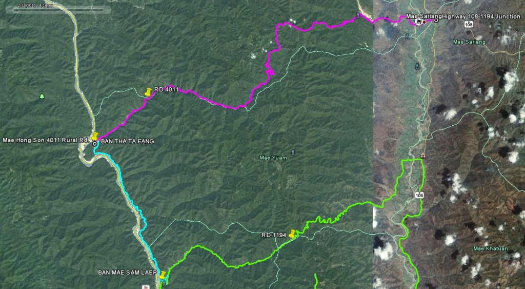
The route 1194, 4011
Total distance 90 km

I took the 1194 out of town heading towards Mae Sam Laep, then took a right onto the 4011 for the Salawin National Park. Once inside the National Park the road is concrete for a very short time then unmade


As I quickly climb its gets a little foggy and its quite a chilly start


Thats all I need, fog but thankfully it soon disappears

Low level cloud through the trees

I see the first person since entering the National Park

Those clouds are lower than me

A couple of walkers come past


Its not a bad surface at the moment, thankfully theres no other traffic kicking up a dust storm


Riding along the ridge and some great scenery


I suddenly hit a longish muddy section with deep puddles that has the bike sliding around


I do a few water crossings but not too deep

Just what I don't need, another stream joining the one that I have already crossed about six times, hopefully no more water crossings


More water crossings, probably about thirty of them in total

In places theres a narrow ledge that I can ride along that saves me a few crossings


Here I have to ride in the water for a way, so far I have managed to stay totally dry


The road climbs and I get a brief break from the water


The first signs of civilization that I have seen for a couple of hours

I don't need any chillies to warm me up I am sweating from the exercise that I am getting


Back to lots more water crossings. I was going to do this trip a month ago, I am glad that I didnt try then as its only just about doable today with the water getting deeper as more streams merge

Six km before Tha Ta Fang and I see the first four wheel vehicle since Mae Sariang


Further on and there's a digger


Nearing Tha Ta Fang and its out of the water and some more great scenery, I am glad that the conditions didnt get bad until I was the best part of the way here as by then it was too close to the goal to turn back


The Salawin

Burma on the other side, the Phantoms gone through all the water crossings okay but I think the Salawin might be just a tad too deep so I don't try


A quick look around the village, its 12.45 so its taken me 3.5 hours to get here, I dont stay long as I have no desire to ride back in the dark should something go wrong


It seems like all the animals are asleep here


Proof that I made it


On the way back and I find it harder as I am riding against a rather fast current and the water soon gets my boots filled up

Riding in the river bed isnt so great on the return and although I dont actually fall off, twice the bike got stuck and I had to get off and pull it out so I am well wet by now, at least the waters warm though.

Halfway home and thankfully the water sections are finished as I was getting concerned at how much punishment the bike was taking. Rocks were hitting against it a lot and I had visions of a split tyre, buckled rim or a hole in the casing, thankfully none of this happened and the only thing that needed doing was oiling the chain

If anyone is thinking of riding this fun route, three pieces of advice.
1 Dont do it on a road bike, I struggled badly today getting back and will only ever try it again on a dual purpose/motard bike. Davidfl did you ride this on the Africa Twin?
2 Have at least two people on the trip, again I struggled pulling the bike out from where it got stuck in the river and there is no help out here
3 Leave fairly early in the morning as it takes a reasonable time and then theres some spare time in case of any problems

Back in Mae Sariang and its the 99 Baht buffet tonight
Got an email from Colin who gave us permission to post this trip he did. He's probably the best source of information of road routes in Thailand as he's done most several times!
The route 1194, 4011
Total distance 90 km

I took the 1194 out of town heading towards Mae Sam Laep, then took a right onto the 4011 for the Salawin National Park. Once inside the National Park the road is concrete for a very short time then unmade


As I quickly climb its gets a little foggy and its quite a chilly start


Thats all I need, fog but thankfully it soon disappears

Low level cloud through the trees

I see the first person since entering the National Park

Those clouds are lower than me

A couple of walkers come past


Its not a bad surface at the moment, thankfully theres no other traffic kicking up a dust storm


Riding along the ridge and some great scenery


I suddenly hit a longish muddy section with deep puddles that has the bike sliding around


I do a few water crossings but not too deep

Just what I don't need, another stream joining the one that I have already crossed about six times, hopefully no more water crossings


More water crossings, probably about thirty of them in total

In places theres a narrow ledge that I can ride along that saves me a few crossings


Here I have to ride in the water for a way, so far I have managed to stay totally dry


The road climbs and I get a brief break from the water


The first signs of civilization that I have seen for a couple of hours

I don't need any chillies to warm me up I am sweating from the exercise that I am getting


Back to lots more water crossings. I was going to do this trip a month ago, I am glad that I didnt try then as its only just about doable today with the water getting deeper as more streams merge

Six km before Tha Ta Fang and I see the first four wheel vehicle since Mae Sariang


Further on and there's a digger


Nearing Tha Ta Fang and its out of the water and some more great scenery, I am glad that the conditions didnt get bad until I was the best part of the way here as by then it was too close to the goal to turn back


The Salawin

Burma on the other side, the Phantoms gone through all the water crossings okay but I think the Salawin might be just a tad too deep so I don't try


A quick look around the village, its 12.45 so its taken me 3.5 hours to get here, I dont stay long as I have no desire to ride back in the dark should something go wrong


It seems like all the animals are asleep here


Proof that I made it


On the way back and I find it harder as I am riding against a rather fast current and the water soon gets my boots filled up

Riding in the river bed isnt so great on the return and although I dont actually fall off, twice the bike got stuck and I had to get off and pull it out so I am well wet by now, at least the waters warm though.

Halfway home and thankfully the water sections are finished as I was getting concerned at how much punishment the bike was taking. Rocks were hitting against it a lot and I had visions of a split tyre, buckled rim or a hole in the casing, thankfully none of this happened and the only thing that needed doing was oiling the chain

If anyone is thinking of riding this fun route, three pieces of advice.
1 Dont do it on a road bike, I struggled badly today getting back and will only ever try it again on a dual purpose/motard bike. Davidfl did you ride this on the Africa Twin?
2 Have at least two people on the trip, again I struggled pulling the bike out from where it got stuck in the river and there is no help out here
3 Leave fairly early in the morning as it takes a reasonable time and then theres some spare time in case of any problems

Back in Mae Sariang and its the 99 Baht buffet tonight


