Ho Chi Minh Trail, Laos - Getting the most out of riding the region.

KTMphil

Senior member
Joined
Jan 11, 2011
Location
Chiang Mai, Thailand
Bikes
2007 KTM 990 Adventure Suzuki DRZ 400
A lot of rider's that are headed towards south Laos, have the intention of immersing themselves in the Ho Chi Minh Trail history, but without some lengthy research, it's not too easy to actually to find things with significant, historic military interest away from tourist museums in larger towns.

Hopefully this thread will develop and give some useful information on how to make the most of the Ho Chi Minh Trail area in south east Laos towards the Vietnam border.

Anyone who has some interesting information(regarding the HMT in Laos), please contribute it here as the area is still a bit mysterious to all of us. Obviously make sure it's not copyrighted etc.......


A brief introduction from Wikipedia:


Ho Chi Minh trail - Wikipedia, the free encyclopedia


The Hồ Chí Minh trail (also known in Vietnam as the "Trường Sơn trail") was a logistical system that ran from the Democratic Republic of Vietnam (North Vietnam) to the Republic of Vietnam (South Vietnam) through the neighboring kingdoms of Laos and Cambodia. The system provided support, in the form of manpower andmateriel, to the National Front for the Liberation of South Vietnam (called the Vietcong or "VC" by its opponents) and the People's Army of Vietnam (PAVN), or North Vietnamese Army, during the Vietnam War.
It was named by the Americans for North Vietnamese president Hồ Chí Minh. Although the trail was mostly in Laos, the communists called it the Trường Sơn Strategic Supply Route, after the Vietnamese name for theAnnamite Range mountains in central Vietnam.[SUP][1][/SUP] According to the United States National Security Agency's official history of the war, the Trail system was "one of the great achievements of military engineering of the 20th century."[SUP][2][/SUP]


Maps below explain where the traffic areas are along the Laos/ Vietnam border:


full map by Triangle Golden 007, on Flickr


hmt wiki 1 by Triangle Golden 007, on Flickr


hmt wiki by Triangle Golden 007, on Flickr
 
Ban Laboy Ford - One of the most heavily bombed places on earth!


During the Southwest Monsoon, from May to November, Route 912 is the enemy’s main road into southern Laos from North Vietnam. For nearly three years, the enemy trucks have utilized an underwater rock causeway to transit the Ban Laboy Ford. Until recently this causeway had never been successfully damaged or fully interdicted.


& it being such an important and successful route for the enemy, it got the shit bombed out of it - take a look at the bomb craters!!
.'


bomb craters by Triangle Golden 007, on Flickr
Photo - Talkingproud


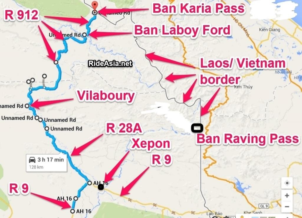
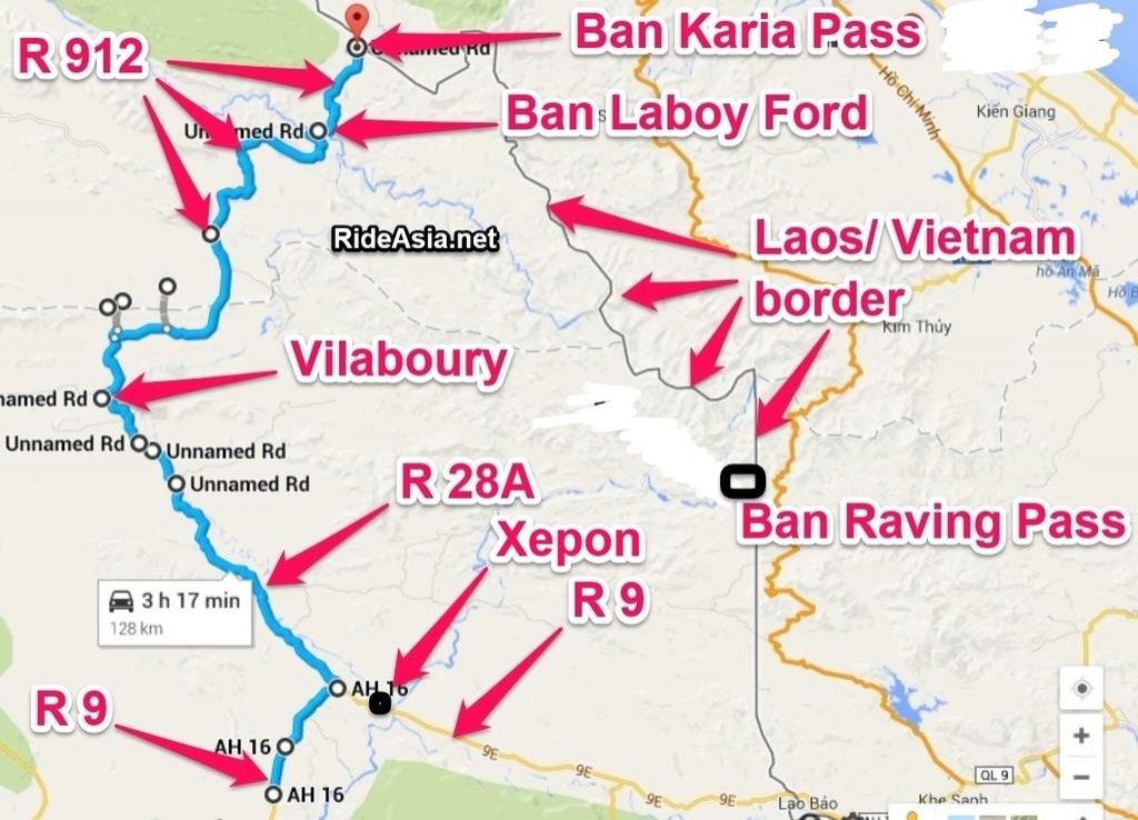
Find Savannakhet in south west Laos on a Laos map, move your finger eastwards towards the Vietnam border to R 9 and look for the town of Xepon (N16.70042 E106.20619). Lots of Ho Chi Minh Trail history around this town and its entry to the historic road that will take you towards Ban Laboy Ford and R 912.


You can see Xepon in the bottom right hand corner of the map below:


map all with txt by Triangle Golden 007, on Flickr


A zoomed version of the same map below. Towards the center you can see the town of Vilaboury on R 28A (co-ords N16.97330 E105.94962) & towards the top Ban Laboy Ford (co-ords: N17.20596 E106.14784) and the Karia Pass (co-ords: N17.28159 E106.18539) into Vietnam all very important parts of the Ho Chi Menh Trail legacy.


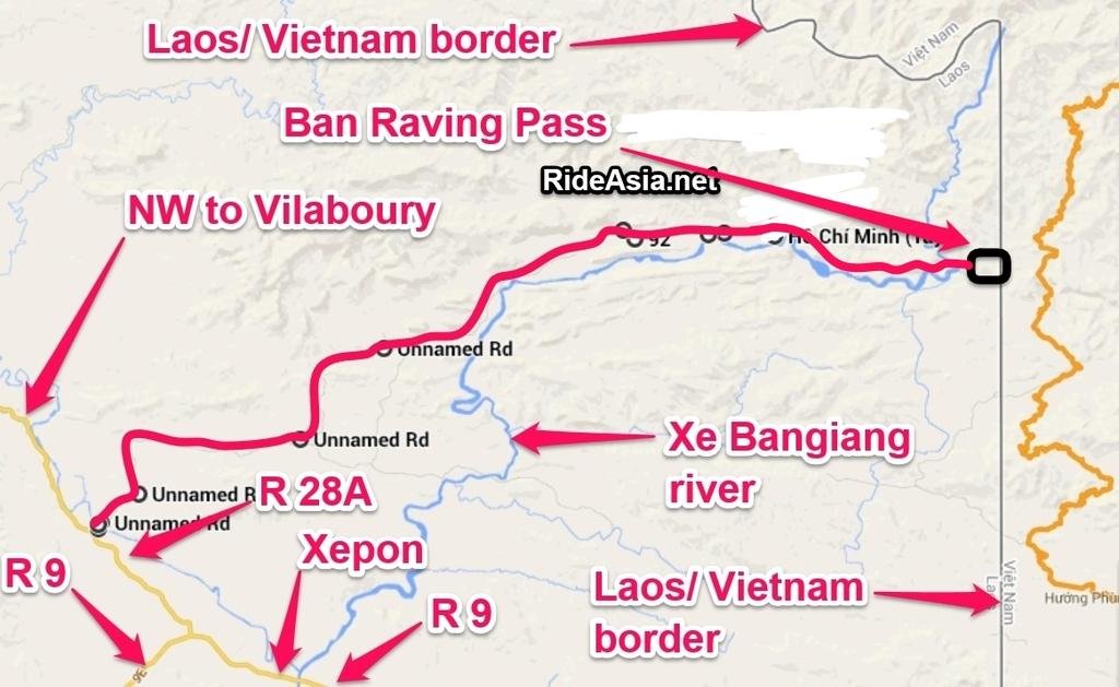
Map revised for location of Ban Raving Pass


banraving pass revised with BKP.jpg


Ban Laboy Ford (co-ords: N17.20596 E106.14784)


ban laboy zoom with txt by Triangle Golden 007, on Flickr


"Talkingproud" website has some fascinating information on the Ho Chi Minh Trail, it's probably one of the best reads on the region. Here's an excerpt from their piece on Ban Laboy Ford - one of the most heavily bombed places on earth:


Ban Laboy, how it fit in


The Ban Laboy Ford was one of two major interdiction points south of the Mu Gia and Ban Karai passes, the other being Ban Sanat. Traffic moved southward from these two points to an expanded road network into Base Area (BA) 604.

Ban Laboy Ford is only about 8 kms south of the Ban Karai. It was a major air interdiction point because enemy traffic had to come out of the triple canopy foliage cover into the open to cross the Ford, and the truck traffic had to employ an underwater rock causeway to hold their weight. Attacking aircraft could either attack the trucks and/or attempt to destroy the causeway, all with the objective of blocking the Ford and causing traffic to back up.


The Ban Laboy was a major interdiction point where Route 912 crossed a canyon of the Nam Ta Le River The Ford itself consisted of a prepared Ford, a cable bridge and a cable ferry-pontoon bridge across the river in Laos. Some pilots referred to it as “The Canyon of Death.” General Keegan wrote this about the Ban Laboy Ford in 1968:

“The Ban Laboy Ford in Laos links Route 137 with Route 912. During the Southwest Monsoon, from May to November, Route 912 is the enemy’s main road into southern Laos from North Vietnam. For nearly three years, the enemy trucks have utilized an underwater rock causeway to transit the Ban Laboy Ford. Until recently this causeway had never been successfully damaged or fully interdicted.

“Ban Laboy was protected by bad weather ... During July and August, daily radar bombing attacks by fighter bombers were conducted against this Ford without visually observed results. Sensors implanted to the north and south of this Ford confirmed in mid-August that the enemy was having great difficulty moving his trucks across the Ford.”


This map was published in the March 2007 edition of the Mekong Express
. In the article, Gerry Frazier described the road crossing the Ford:

“On the map, we see an ‘improved’ road near the two Ban Loboy sites. The road, which enters Laos from North Vietnam a few kilometers to the north, descends a hillside, then turns west along the north bank of a stream, crosses to the south bank, and runs east again before continuing south. On the map, the road takes a ‘switchback’ turn. The main ford was at the west end of the switchback. As you go north, (up hill) you can see that the road is designated 912, and it crosses the border between
North Vietnam and Laos. Although this map does not show it, the place the road crosses the border was called Ban Karai Pass".


14455383616_a13d169187_b.jpg
[/URL]


If you're planning on heading down there, you'd be mad not to get Midnite Mappers GPS map, it has an unbelievable amount of points-of-interest data, cobblestones of the original Ho Chi Menh Trail, downed heicopters, tanks etc.... it's all there, link below of where you can get it (there's a new 2014 version just released too):


Laos GPS Map & The Ho Chi Minh Trail


Not sure if it's worth it? Take a look at his HMT photo's, it might convince you! Link below:


Ho Chi Minh trail past and present, hundreds of present day photos of the Ho Chi Minh Trail | Laos GPS Map


.
 
Some great info there Phil, definitely on the to do list in the near future, i did touch on a small section of the trail earlier this year although by accident.
 
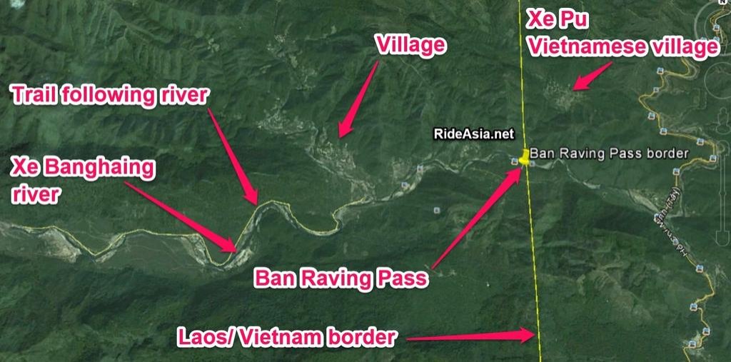
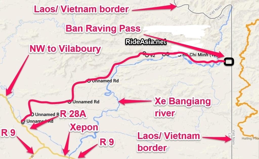
Ban Raving Pass

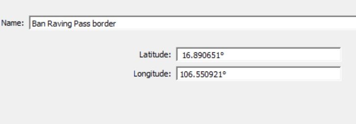
REVISED CO-ORDS:

N16.89065

E106.55092


Ban Raving Pass: A mountain pass connecting North Vietnam and Laos just northwest of the demilitarized zone.Rising to prominence following the 1968 halt of the bombing of North Vietnam,the road was designated Route 1036 in North Vietnam and Route 92 in Laos .


South of Ban Karia Pass, another trafficking route into Laos from the Vietnam border, Ban Raving Pass.


ban raving pass revised with txt.jpg


banraving pass revised with BKP.jpg


From:

http://www.vlink.com/nlvnch/lamson719/lamson3.html

Route 1039, also originating in North Vietnam passed through the Ban Raving Pass and offered access into Tchepone and base area 604 then connected with either Route 29 to go further south or with Route 914 which led into base area 611 and from there into South Vietnam. All these routes were well maintained two lane roads practicable for large trucks at least during the dry season. Due to extensive bombings, the enemy had built several alternate routes which were well concealed by vegetation and often under double and triple canopies. In addition to main routes, the enemy also built narrow pathways crisscrossing the entire area. These were difficult to observe from the air and were convenient for concealing troop movements.
February in the Tchepone area was the transitional period from the northeast to the southwest monsoons. The northeast monsoon, which brought rains and cloudiness to Central Vietnam above the Hai Van Pass from October to March, was the dominant weather factor. The Truong Son mountain range deflected much of this wet weather on the Laotian side but in the area of operation, the skies were generally covered. The amount of cumulus buildup in this area depended on the strength and depth of the monsoon. Average temperature during February was 220C in the lowlands and about 180C in mountainous regions.


Some locations of some other key places on the Ho Chi Minh Trail (CO-ORDS FOR BAN RAVING PASS ARE INNACURATE):


ALPHA: A highly defended interdiction point (approx. 17 deg 02 min N; 105 deg 58 min E) in Steel Tiger. ALPHA was visually identifiable by a large karst rock formation just south of the intersection of Routes 911 and 912 in the Laotian panhandle. ALPHA and the nearby interdiction points,
BRAVO and CHARLIE, were known as the Chokes.
Ban Karai Pass: A key pass (Approx. 17 deg N; 106 deg 11 min E) through the Annamite Mountains. Opened to truck traffic in early 1966 when the Communists built Route 137 from the coastal area near Quang Khe, North Vietnam, and Route 912 in Laos to join Route 911 just above the Chokes.
Ban Laboy Ford: A key interdiction point (Approx. 17 deg 12 min N; 106 deg 10 min E) in Steel Tiger where Route 912 crossed the Nam Ta Le River.
Ban Raving Pass: A mountain pass (Approx. 17 deg 17 min N; 106 deg 11 min E) connecting North Vietnam and Laos just northwest of the demilitarized zone. Rising to prominence following the 1968 halt of the bombing of North Vietnam, the road was designated Route 1036 in North Vietnam and Route 92 in Laos .
BRAVO: Heavily defended interdiction point (Approx 17 deg 01 min N; 105 deg 55 min E) on Route 911 in Central Laos. Westernmost of three interdiction points known as the Chokes.
CHARLIE: Heavily defended chokepoint (Approx. 17 deg 00 min N; 105 deg 58 min E) in Steel Tiger. CHARLIE was the southernmost of the three interdiction points known as the Chokes.
DELTA: An interdiction point (Approx. 16 deg 53 min N; 106 deg 01 min E) on Route 911 about halfway between the Chokes and Tchepone.
Dog House: Nickname given to the heavily defended Laotian valley and storage complex just south of the Mu Gia Pass.
ECHO: An interdiction point (Approx. 16 deg 49 min N; 106 deg 05 min E) on the Laotian Route 91 just east of its intersection with Route 911.
FOXTROT: A key interdiction point (Approx. 16 deg 47 min N; 106 deg 06 min E) on Route 91 at the southern edge of Steel Tiger North, just northwest of Tchepone.
GOLF: An interdiction point (Approx. 17 deg 12 min N; 105 deg 50 min E) on Route 911 between the Mu Gia Pass and the Chokes. GOLF was the focus of a concentrated air attack during the month of April 1968.
Harley's Valley: Name given by the 23rd TASS FACs to a large meadow between the Ban Laboy Ford and the Laotian/North Vietnamese border. The area was named for Captain Lee D. Harley who was listed as missing in action on May 18, 1966, when his Owas shot down over the eastern part of the meadow.
HOTEL: An interdiction point on Route 912 about a mile south of the Ban Laboy Ford (Approx 17 deg 11 min N; 106 deg 09 min E).
HUB: The name of an aerial interdiction operation in March 1967 against a segment of Route 911 just south of the Chokes. The target was an unbypassed segment of road in the vicinity of 16 deg 58 min N; 105 deg 58 min E .


Credit:
http://chancefac.tripod.com/Maps/Laos/Interdiction_Points_Laos.htm
 
Last edited:
Mu (Mi) Gua Pass


The pass was the principal point of entry into the Ho Chi Minh Trail through Laos.[SUP][1][/SUP] A CIA landscape analysis prepared in February 1966 described Route 15 as threading "its way upstream along a narrow, steep-sided valley.


Location:


N17.66762

E105.76354


From Talking proud:


http://www.talkingproud.us/Military/Birddog/BirddogHeiskill/BirddogHeiskill.html


On the way to the Mu Gia Pass, they heard "Crown" call for any pilot in the area to respond and assist in suppressing ground fire in the heavily fortified pass.


f4clearedhot.jpg


An F-4 Phantom on his way back from a mission in North Vietnam responded to Crown. He had one 500 lb bomb, and a gatling gun, but was low on gas. He volunteered to make one pass at the 37mm anti aircraft gun that was causing havoc. He did not want to use his gun against the 37 mm anti-aircraft emplacement because that was "risky business". In the early '60's, F-4's were known to be notorious for inaccurate bombing accuracy. The F-4 pilot dropped the 500 lb bomb and missed by hundreds of yards. Low on fuel, the F-4 pilot promptly vacated the area to make it safely back to Ubon RTAFB, Thailand.


mi gua pass with txt by Triangle Golden 007, on Flickr


Wikipedia:

M? Gi? Pass - Wikipedia, the free encyclopedia


The pass was the principal point of entry into the Ho Chi Minh Trail through Laos.[SUP][1][/SUP] A CIA landscape analysis prepared in February 1966 described Route 15 as threading "its way upstream along a narrow, steep-sided valley. To the left rise dog-toothed limestone peaks, to the right is a flat-topped plateau. Dense tropical rain forest covers the entire area, almost frustrating aerial observation. The road is carved out of the steep hillside, for in most places there is not enough room for both road and stream in the constricted bottom of the ravine".[SUP][2][/SUP] Due to its difficult geography, the pass was identified as a choke point,[SUP][3][/SUP] and, as a result, was heavily bombed first as part ofOperation Barrel Roll and later as part of Operation Rolling Thunder and Operation Commando Hunt. By March 1966, it was estimated that 75% of all truck traffic into Laos went through the pass.[SUP][4][/SUP]
On 12 April 1966, 29 B-52s attacked the pass for the first time in the largest bombing mission since World War II, using a combination of subsurface and delayed action bombs over a 5 km section, but the pass was not closed by landslides as had been hoped for.[SUP][5][/SUP] A second B-52 strike took place on 26 April but the damage was repaired within 10 hours and convoys were seen using the pass the next day. A CIA report noted that the "Communists will spare no effort to keep it open".[SUP][6][/SUP] Despite frequent bombing, the United States Air Force and United States Navy were never able to put the pass out of operation for any sustained period of time. The North Vietnamese Army (NVA) also constructed several bypass roads around the pass to the east and west of Route 12 in Laos[SUP][3][/SUP] and later a series of petrol, oil and lubricants (POL) pipelines through the pass. The NVA progressively built up their air defences around the pass, first installing smaller calibre anti-aircraft artillery (AAA), then larger calibre (100mm) AAA, by 1966 more than 300 AAA sites had been identified around the pass.[SUP][7][/SUP] By 1972 SAM-2 missiles covered approaches to the pass, forcing B-52s and gunships to keep their distance reducing the interdiction effort.[SUP][8][/SUP]
 
Ho Chi Menh Trail, "Alpha-Charlie" Military strategic waypoints


Just plotted all the Alpha-Charlie waypoints from the URL:http://chancefac.tripod.com/Maps/Laos/Interdiction_Points_Laos.htm


Waypoints can be found in the Garmin waypoint file attached. Also opened the waypoints in a map viewer, most are centralized around the Vilaboury area and towards Ban Laboy Ford.


alphacharlie waypoints with txt by Triangle Golden 007, on Flickr


A description of the military waypoints below (CO-ORDS FOR BAN RAVING PASS ARE INNACURATE):


ALPHA: A highly defended interdiction point (approx. 17 deg 02 min N; 105 deg 58 min E) in Steel Tiger. ALPHA was visually identifiable by a large karst rock formation just south of the intersection of Routes 911 and 912 in the Laotian panhandle. ALPHA and the nearby interdiction points,
BRAVO and CHARLIE, were known as the Chokes.
Ban Karai Pass: A key pass (Approx. 17 deg N; 106 deg 11 min E) through the Annamite Mountains. Opened to truck traffic in early 1966 when the Communists built Route 137 from the coastal area near Quang Khe, North Vietnam, and Route 912 in Laos to join Route 911 just above the Chokes.
Ban Laboy Ford: A key interdiction point (Approx. 17 deg 12 min N; 106 deg 10 min E) in Steel Tiger where Route 912 crossed the Nam Ta Le River.
Ban Raving Pass: A mountain pass (Approx. 17 deg 17 min N; 106 deg 11 min E) connecting North Vietnam and Laos just northwest of the demilitarized zone. Rising to prominence following the 1968 halt of the bombing of North Vietnam, the road was designated Route 1036 in North Vietnam and Route 92 in Laos .
BRAVO: Heavily defended interdiction point (Approx 17 deg 01 min N; 105 deg 55 min E) on Route 911 in Central Laos. Westernmost of three interdiction points known as the Chokes.
CHARLIE: Heavily defended chokepoint (Approx. 17 deg 00 min N; 105 deg 58 min E) in Steel Tiger. CHARLIE was the southernmost of the three interdiction points known as the Chokes.
DELTA: An interdiction point (Approx. 16 deg 53 min N; 106 deg 01 min E) on Route 911 about halfway between the Chokes and Tchepone.
Dog House: Nickname given to the heavily defended Laotian valley and storage complex just south of the Mu Gia Pass.
ECHO: An interdiction point (Approx. 16 deg 49 min N; 106 deg 05 min E) on the Laotian Route 91 just east of its intersection with Route 911.
FOXTROT: A key interdiction point (Approx. 16 deg 47 min N; 106 deg 06 min E) on Route 91 at the southern edge of Steel Tiger North, just northwest of Tchepone.
GOLF: An interdiction point (Approx. 17 deg 12 min N; 105 deg 50 min E) on Route 911 between the Mu Gia Pass and the Chokes. GOLF was the focus of a concentrated air attack during the month of April 1968.
Harley's Valley: Name given by the 23rd TASS FACs to a large meadow between the Ban Laboy Ford and the Laotian/North Vietnamese border. The area was named for Captain Lee D. Harley who was listed as missing in action on May 18, 1966, when his Owas shot down over the eastern part of the meadow.
HOTEL: An interdiction point on Route 912 about a mile south of the Ban Laboy Ford (Approx 17 deg 11 min N; 106 deg 09 min E).
HUB: The name of an aerial interdiction operation in March 1967 against a segment of Route 911 just south of the Chokes. The target was an unbypassed segment of road in the vicinity of 16 deg 58 min N; 105 deg 58 min E .
 

Attachments

  • Alpha charlie waypoints.gdb
    1.5 KB · Views: 420
Great information you have here, Phil.
Thought the HCM trail in Laos could not be explored by my bloody heavy GS. Need a smaller lighter dualsport bike, right?
 
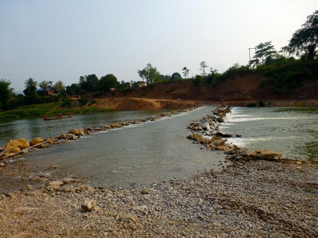
Nah, you will ok crossing with the GS here Viethorse :ride:

P1030071_zps5c4f665f.jpg
 
Great information you have here, Phil.
Thought the HCM trail in Laos could not be explored by my bloody heavy GS. Need a smaller lighter dualsport bike, right?


Trung - A lot of it is 4X4 pickup roads, in theory the GS 1200 can do all of this, although if its wet, I wouldn't want to be on a loaded GS 1200 there when it's like that. You're best off on a 250cc enduro bike as it opens up all opportunites.
 
I wouldn't have made it down the trail on my Super Enduro in the wet... and its a LOT lighter than a GS 1200.

Here's that same crossing as in post 14, from the other side... but in the wet season. Its boat only then... and even with the "lightweight" 525, we were shipping water over the ends of the boat


.... and it was nasty enough manhandling it out of these sort of bogs. Not sure I'd want to do that with a GS


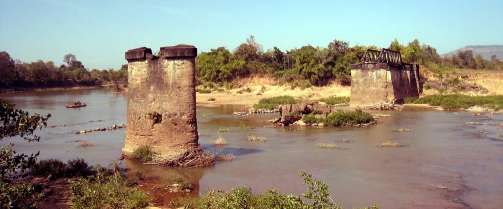
Speaking of the bombed bridges


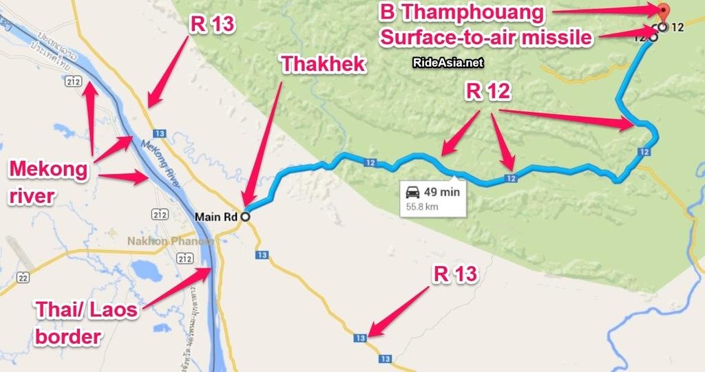
There's another one of those... east of Thakhek - not far from where Route 12 diverges from 1E at N17° 33.696' E105° 10.519'.

You need to drive in off the road, as its behind these buildings.

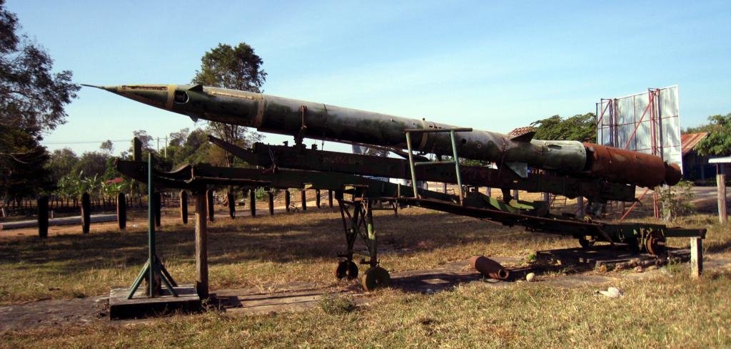
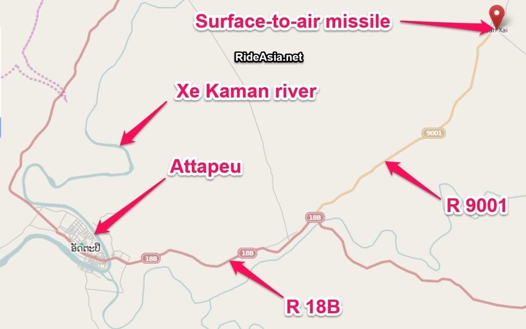
This one had been bombed and is missing the solid rocket booster. Both are SAM 2's. The one above was towed down the HCM Trail by a tank on that trailer and never fired. The one below has a fair amount of damage.

 
Somewhere around here I think:


Thakhek SAR.jpg


There's another one of those... east of Thakhek - not far from where Route 12 diverges from 1E at N17° 33.696' E105° 10.519'.

You need to drive in off the road, as its behind these buildings.

This one had been bombed and is missing the solid rocket booster. Both are SAM 2's. The one above was towed down the HCM Trail by a tank on that trailer and never fired. The one below has a fair amount of damage.

 
A better one of that second SAM 2


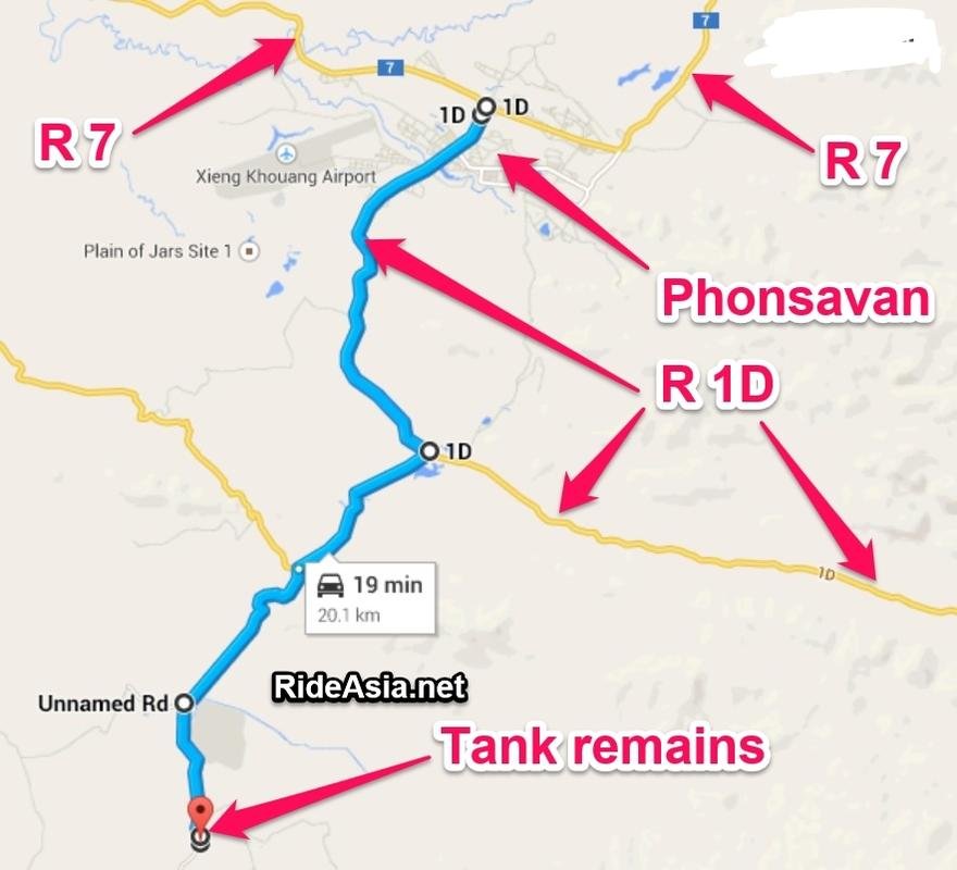
At N19° 19.426' E103° 08.594' there is a tank that has hit a mine.


Jump the fence (more carefully than me, as I ripped the arse out of my jeans on the barbed wire)... and you can detect the damage in the floor of the tank. It was given to me as a T72. It ain't a T72 - I think its a PT-76 at a guess, as it has a welded turret with that distinctive oval opening on top.


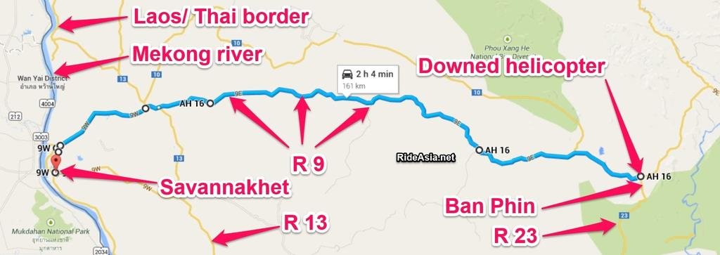
Then, there's this shot-down American chopper - and I think that's at N16° 32.080' E106° 01.322' in Phin, near the intersection of Route 9 and 23 / 1G

 
Yep, that's them.

One good thing about doing it in the wet season. There's no dust.


None at all


If anyone is thinking of doing it... do it sooner, rather than later. That section with the photos above had, IIRC, three new bridges being built.


Damn road will be able to take a BMW soon

.... incidentally, regarding that first photo... those guys needed my muscle to get through there... and I needed theirs. It was a tad sticky.
 
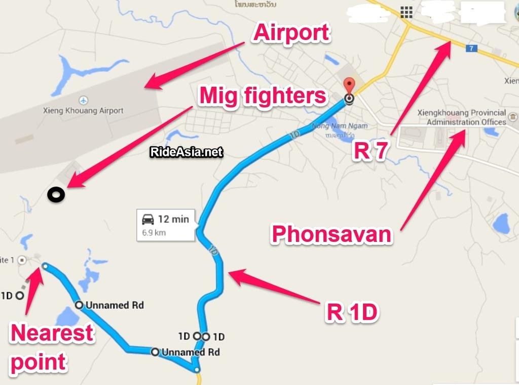
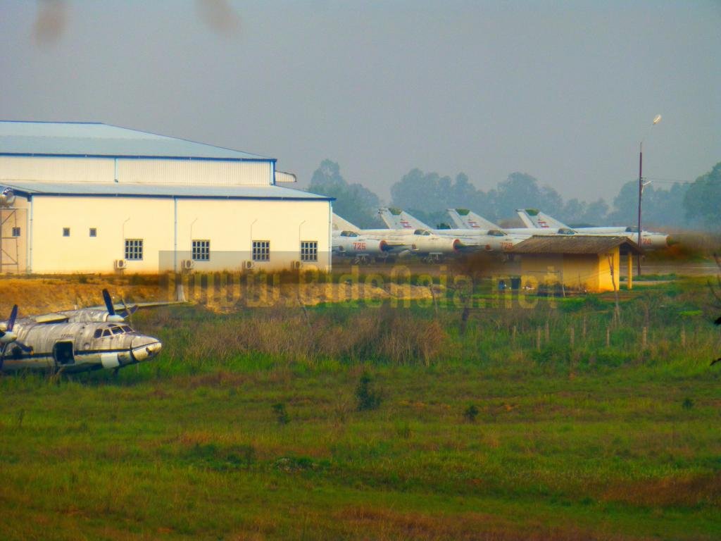
Mig fighter planes at Phonsavan airport


You used to be able to get 80 meters away from the Mig's, some reports say you can't get as close now.


mig fighters.jpg


5711990946_925c60fe95_b.jpg
 
Mig fighter planes at Phonsavan airport


You used to be able to get 80 meters away from the Mig's, some reports say you can't get as close now.


View attachment 29624


5711990946_925c60fe95_b.jpg

There is a big hanger type building shielding your view now, this was the nearest i could get back in April 2014.

P1020836_zps457fb0b5.jpg
 
Ban Raving Pass: A mountain pass (Approx. 17 deg 17 min N; 106 deg 11 min E)connecting North Vietnam and Laos just northwest of the demilitarized zone.

These are pretty much the same coordinates as for the Karia pass. Looks like a mix up.

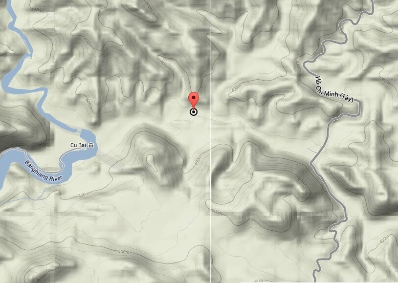
The Raving pass is probably somewhere not too far from N16.89261 E106.54859 where there is a river.

raving_pass.jpg
 
Last edited:
Those military co-ords for Ban Raving Pass were off. Took a look in google earth and it looks like the Vietnam border and Ban Raving Pass is here, in the same location as you mention (I've adjusted the BRP maps in the previous posts):


BRP GE with RA.jpg


From Google Earth:


BRV pass border co-ords.jpg


ban raving pass revised with txt.jpg
 
I'd be interested to hear people's views on whether the Ho Chi Minh Trail name applies to any areas in Vietnam? What I've read applies it to Laos and Cambodia, but not Vietnam, but there seems to be a lot of application of the name, mostly by tour companies, to tracks in Vietnam.

Meanwhile, this site has some interesting Google Earth maps of the bombing sorties in different provinces of Laos. One gets a pretty decent idea of where the trail was. Here's a snip of the Khammouane Province data

The height of the stack indicates the number of bombs.


This one was in the MAG office in Phonsavan and is for that area (Plain of Jars)


and the usually seen overall map

20121025-154802.jpg
 
At N19° 19.426' E103° 08.594' there is a tank that has hit a mine.


Jump the fence (more carefully than me, as I ripped the arse out of my jeans on the barbed wire)... and you can detect the damage in the floor of the tank. It was given to me as a T72. It ain't a T72 - I think its a PT-76 at a guess, as it has a welded turret with that distinctive oval opening on top.


Yes, had a look today at the tank while travelling with a friend from Long Chieng to Phonsavan and he identified it also as a PT-76 (amphibious tank)
 
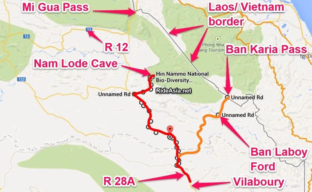
Nam Lode Cave


80km north of Vilaboury (Vilabouri). A tunnel cave south of the Mi (Mu) Gua Pass, north of Ban Laboy Ford & Ban Karia Pass. This would have been used as shelter during the Vietnam war for sure,as its on the route south, looks like it could be worth a visit.


Co-ords:

N17.37412

E105.83862


From:

http://www.rideasia.net/motorcycle-...am-khoun-xe-also-known-nam-lode-lod-cave.html


Khammuan opens 11km long cave to visitors

Khammuan authorities last week officially opened Tham Nam Lod Cave to visitors, touting it as one of the province's most intriguing attractions and hoping it will entice more people to visit the area. The opening ceremony took place at the cave in Nongping village in Bualapha district, and was attended by senior officials from the province. Speaking at the ceremony, the Vice Governor of Khammuan province, Mr Somchay Phetsinouane, said the opening of the cave was of great significance to local people, especially those in Nongping village and neighboring communities.


NAM LODE CAVE WITH TXT.jpg


16297d1365816488t-another-mapping-trip-laos-xbf-cave-1.jpg
 
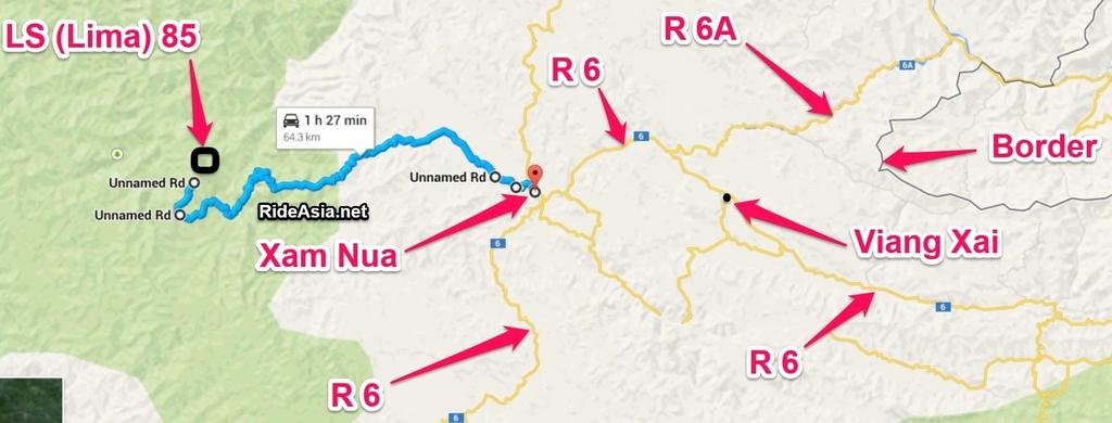
LS 85 / Lima 85


One of the most famous "secret war" command stations in Laos, co-ords:


N20.46817


E103.72561


800px-LimaSite85-descriptions.jpg

Photo: Wikipedia


Wikipedia:


Lima Site 85 - Wikipedia, the free encyclopedia


Lima Site 85 (LS-85 alphanumeric code of the phonetic 1st letter used to conceal this covert operation)[SUP][citation needed][/SUP] was a clandestine Laos military installation of the Hmong "Secret Army", the Central Intelligence Agency, and the United States Air Force used for Vietnam War covert operations against communist targets in ostensibly neutral Laos. Initially created for a CIA command post to support a local stronghold, the site was expanded with a 1966 TACAN area excavated on the mountaintop where a 1967 command guidance radar was added for Commando Club bombing of northern areas of North Vietnam. The site ended operations with theBattle of Lima Site 85 when most of the U.S. technicians on the mountaintop were killed, including CMSgt Richard Etchberger who was awarded the Medal of Honor.


Xam Nua makes an easy base, Lima 85 is approx 65km to the west:

lima 85 with txt.jpgView attachment 29641
 
This is all fascinating to read, as this war was on when I was 17 and was in the Merchant Navy doing long oversea trips. Spent a lot of time going through the Panama Canal, which was the training ground for G.I.'s going to the war.It was the closest jungle to what to expect when they got Asia. Many wild nights before they were posted and sent to Vietnam.
Now much older and retired in Thailand, but the biking bug is still very much alive, and would like to do a trip to see all this area. Is there a company who organises the whole package?
Bike hire, visas, and guided tour. Chaing Mai seems to be the place to start from, any suggestions or help would be appreciated. Cheers.
 
LS 85 / Lima 85


One of the most famous "secret war" command stations in Laos, co-ords:


N20.46817


E103.72561


800px-LimaSite85-descriptions.jpg

Photo: Wikipedia

Wikipedia:

Lima Site 85 - Wikipedia, the free encyclopedia

Lima Site 85 (LS-85 alphanumeric code of the phonetic 1st letter used to conceal this covert operation)[SUP][citation needed][/SUP] was a clandestine Laos military installation of the Hmong "Secret Army", the Central Intelligence Agency, and the United States Air Force used for Vietnam War covert operations against communist targets in ostensibly neutral Laos. Initially created for a CIA command post to support a local stronghold, the site was expanded with a 1966 TACAN area excavated on the mountaintop where a 1967 command guidance radar was added for Commando Club bombing of northern areas of North Vietnam. The site ended operations with theBattle of Lima Site 85 when most of the U.S. technicians on the mountaintop were killed, including CMSgt Richard Etchberger who was awarded the Medal of Honor.

Xam Nua makes an easy base, Lima 85 is approx 65km to the west:

View attachment 29642View attachment 29641

Lima 85 is still very much restricted and you can expect trouble in case you get close to the area. I think Robert Hiekel and his friend has some unpleasant experiences over-there when they strayed to close to the area
 
I'd be interested to hear people's views on whether the Ho Chi Minh Trail name applies to any areas in Vietnam? What I've read applies it to Laos and Cambodia, but not Vietnam, but there seems to be a lot of application of the name, mostly by tour companies, to tracks in Vietnam.

There is a road named Ho Chi Minh trail in Vietnam. It runs along the border to Laos. To my limited knowledge on the subject it has nothing to do with the Vietnam war. I also believe the term only applies to areas in Laos and Cambodia by definition because the purpose for these routes was to transport troops and equipment through neutral areas not (yet) involved in the war.
 
Back
Top Bottom