Captain_Slash
Community Manager
- Joined
- Jun 28, 2011
- Bikes
- BMW 310GS Honda Wave 125 Honda MSX 125
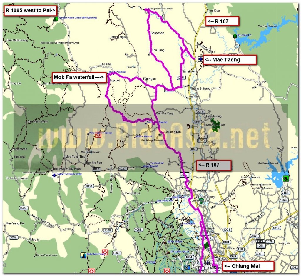
The route 107, 3009, 1095, 4020, 3162, 4235, 121, 3029, 108
Total distance 201 km

On the canal road heading north from the 1096 on the left side of the canal


The canal veers off to the right


This is a well surfaced twisty road

I take the 3009 and take a left to try out a new road for me that leads to the 1095

The road turns to unpaved at N19.02.167 E098.51.630


Quite a lot of water along this off road track


This is a most enjoyable track, not too rough and most importantly its a dry surface


I reach Ban Lak


Occasionally the road is concreted for short spells but its mainly dirt


I run into the concreting gang

Help was needed to get through here, they put some large stones down for me to ride over the shuttering then the concrete pipe was rolled out the way and then finally the bike was manhandled through

Anyone coming through here in a four wheeled vehicle would have been turned back


A few wooden bridges were crossed today but all safe ones


A bit of a generation gap between these two photos


The permanently paved surface starts at N19.06.770 E098.46.640 and just past here is the Mokfa waterfall, I dont bother walking to it

A short way along the 4020 and a new resort by the look of it


The 4020 has some nice curves

Plus good scenery


The Mae Taeng river at Muang Khut


I ride along the 3162 and before reaching the 107 take a right onto an unnumbered road that also goes to the 107, this was along that road

I take a right to head south and reach the canal road

As I am only about 1 km south of the Mae Taeng river I ride north to the source of the irrigation canal

I am now standing in the middle of the Mae Taeng but as I am standing on the weir I remain dry as all the water is being diverted into the irrigation canal

Here is where the water is all flowing to


Nice well tended grounds here


I ride back along the canal then take a right over it and the road turns to dirt at N19.07.866 E098.55.457 until N19.07.356 E098.55.208 where its an asphalt surface and is the 4235.
South of the 1095 I encounter another short spell of dirt between N19.04.364 E098.52.119 and N19.04.235 E098.52.094

A lasagna at Pizza n Pasta tonight
You can get the gdb file from my website here … http://www.captainslash.com
Total distance 201 km

On the canal road heading north from the 1096 on the left side of the canal


The canal veers off to the right


This is a well surfaced twisty road

I take the 3009 and take a left to try out a new road for me that leads to the 1095

The road turns to unpaved at N19.02.167 E098.51.630


Quite a lot of water along this off road track


This is a most enjoyable track, not too rough and most importantly its a dry surface


I reach Ban Lak


Occasionally the road is concreted for short spells but its mainly dirt


I run into the concreting gang

Help was needed to get through here, they put some large stones down for me to ride over the shuttering then the concrete pipe was rolled out the way and then finally the bike was manhandled through

Anyone coming through here in a four wheeled vehicle would have been turned back


A few wooden bridges were crossed today but all safe ones


A bit of a generation gap between these two photos


The permanently paved surface starts at N19.06.770 E098.46.640 and just past here is the Mokfa waterfall, I dont bother walking to it

A short way along the 4020 and a new resort by the look of it


The 4020 has some nice curves

Plus good scenery


The Mae Taeng river at Muang Khut


I ride along the 3162 and before reaching the 107 take a right onto an unnumbered road that also goes to the 107, this was along that road

I take a right to head south and reach the canal road

As I am only about 1 km south of the Mae Taeng river I ride north to the source of the irrigation canal

I am now standing in the middle of the Mae Taeng but as I am standing on the weir I remain dry as all the water is being diverted into the irrigation canal

Here is where the water is all flowing to


Nice well tended grounds here


I ride back along the canal then take a right over it and the road turns to dirt at N19.07.866 E098.55.457 until N19.07.356 E098.55.208 where its an asphalt surface and is the 4235.
South of the 1095 I encounter another short spell of dirt between N19.04.364 E098.52.119 and N19.04.235 E098.52.094

A lasagna at Pizza n Pasta tonight
You can get the gdb file from my website here … http://www.captainslash.com


