Trip to Western Laos - January 2014

Lone Rider

Blokes Who Can
Joined
Jan 29, 2011
Location
Chiangmai
Bikes
4 Wheels
Trip to Western Laos

As the title say, this was a trip to the western part of Laos or rather the west of Xayaboury province but the trip started with a visit to the east to help celebrate a wedding aniversary and 2 birthdays and what a party it was. The first guests from the village showed up around 9 in the morning and they showed off their Ramwong skills and from then on the party went on till late night.

IMG_7030.jpg


The happy couple celebrating their 24th wedding anniversary while Mom and her daughter (on the left) celebrated their birthdays
IMG_7060.jpg


After the party it was "back to work" again for me as the Laos GPS map needed updating while also adding new data.

A rock formation which looked from afar as a Buddha Statue
IMG_7011.jpg


Not sure what this was all about
P1070985.jpg


Abandoned temples in villages which were resettled for hydropower projects
P1070998.jpg


IMG_7023.jpg


IMG_7024.jpg


Construction has started of one of the many hydropower projects planned in Laos - this one is being built in a National Biodiversity Conservation Area
IMG_6987.jpg


IMG_6990.jpg


IMG_6993.jpg


IMG_7001.jpg


Road 11 along the Mekong river from Vientiane to Ban Thanasa is being upgraded and they have started paving it - not sure how long the racetrack quality will last though as this stretch of the road often resembled one big mud puddle in the rainy season

IMG_7159.jpg


IMG_7160.jpg


The Mekong is still quite high
IMG_7163.jpg


The Paklay bridge (Nasak - Khokhaodo) is taking shape but I am not sure if the bridge will be ready by the end of this year as is planned.

IMG_7171.jpg


IMG_7178.jpg


Wanted to have a look at the new International Border Crossing between Thailand (Pudoo-Utaaradit) and Laos (Paklay) but I was stopped at Ban Phakeo were at this moment the Customs and Immigration is located. I was following one of the big trucks transporting cement from Thailand to the Xayaboury Hydropower Project as they are using already the new border crossing.
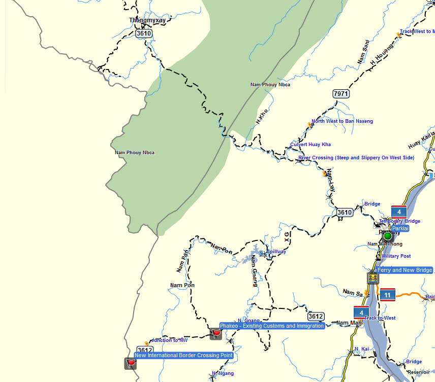
Laos Paklay crossing.PNG

When the Laos Immigration people came running to stop me I realized that I was already past the existing border crossing in Ban Phakeo so I had to beat a hasty retreat to behind their barrier. Still not sure when the new crossing will be fully operational but I guess that, once the new road is ready in about 4 months or so, the border crossing will open as an International Border Crossing.

The Phakeo Border Facilities and part of the new paved road from Highway 4 to the new international border crossing
IMG_7187.jpg


IMG_7194.jpg


IMG_7191.jpg


To be continued
 
Trip to Western Laos - January 2014 - Part 2

After a nice but quite cold evening in Paklay (stayed the night in the Pa Do Guesthouse and had a nice dinner at the Saendee/Sandee restaurant opposite the Duangchai Phet Hotel) I started early for a trip to the Thongmixai District. My last visit to this place was quite some time ago but this time, besides updating the Laos GPS map, I wanted to check up on the border roads as this area is still one of the disputed areas between Laos and Thailand with both countries claiming villages like Ban Savang as being theirs.

The turnoff to the Thongmixai district is just north of Paklay right after crossing the new bridge over the Nam Lai (junction at N18.22861 E101.40722) where you leave Highway 4 and head west along Rd. 3610. This road is unpaved and quite dusty (thick layers of "bull dust") all the way to the District Center. This road goes for a part through the Nam Phouy National Bidodiversity Conservation Area and early in the morning the views over the forest were great with fog still lingering in the valleys.

IMG_7206.jpg


IMG_7208.jpg


IMG_7205.jpg


View from the hills of the Thongmixay District Center
IMG_7225.jpg


The district center of Thongmixai is quite small and one of the very few things worthwhile to visit is an ancient stupa - That Nang Sam Phiou (N18.40935 E101.17383). Very little is known about the stupa but a study carried out by the "Ecole Francaise d'Extreme Orient" indicates that the stupa may be related to a temple established at the island of Don Hon in the Mekong river during the reign of King Vixun (the King of Lan Xang) as well as stupas located at Ban Khokngiou opposite Paklay (see "Pour une Geographie Historique du Bouddhisme au Laos" by Michel Lorillard - Efeo - http://laos.efeo.fr/IMG/pdf/EFEO_Etudes_thematiques_18_Laos_Lorrillard.pdf).

IMG_7210.jpg


IMG_7211.jpg


With regard to Ban Savang being Thai or Lao I will leave that question unanswered but the people in Ban Savang considered themselves to be Lao. While I "crossed" the border shown on both the Thai and Lao maps as well as in Google Earth I found myself some 1.5 km. in Thailand but there was still a Lao Government school beside the road as well as Lao Health Center. I could have gone further but as I was in a kind of "disputed area" I decided that it would be better to turn back. Chang-Noi, who was some time ago on the Thai side (Ban Bo-Bia on Rd. 1123) indicated that the Thai military was not very happy in case he would continue beyond their check-points near the points "Unpaved" and "Residential road and Unpaved".

The Yellow line shows the International Border (very similar with the border lines shown on both the Thai and Laos maps), the Green line is the track of my trip in Laos and the Magenta line is the road/track in Thailand
BanSavang.jpg


By the way, the green line which disappears on the top of the map is the track (Rd. 3609) which goes through the Nam Phouy National Bidodiversity Conservation Area all the way along the border to the Phieng District Center where the track links with Rd 4 at N18.92281 E101.51614 This track has been upgraded and is a very nice trip to do on a bike - sorry, no pictures as I was to busy to keep the truck on the track.

To be continued
 
Trip to Western Laos - January 2014 - Part 3

Arriving a bit late in Xayaboury I did manage to find the Vang Moung khoun Guesthouse just on the other side of the river a bit north of a development area where quite a few of the Government Offices will be relocated in the near future.

IMG_7252.jpg


Had dinner in my regular place on the river - the Saynamhoung Restaurant. The restaurant has lost quite a bit of space as the local government constructs new walkways along the river and the restaurant which was located more or less in the river has now been cut in half. By the way, the food is really good but check the bill before you pay as my bill was padded a bit with beers I had not ordered nor ever seen on my table.

The view from Saynamhoung restaurant
IMG_7259.jpg


The next morning another I had again an early start as I wanted to take the dirt track west from Xayaboury to Saysathan which is a new district and from there head north to Hongsa (total distance about 145 km.)
IMG_7262.jpg


At places the tracks were very steep
IMG_7264.jpg


The elevation profile of the trip from Xayaboury to Hongsa via the Saysathan District
ElevationProfile.png


IMG_7268.jpg


Ban Khonphiat in the valley where you cross the Nam Houng River
IMG_7269.jpg


IMG_7272.jpg


IMG_7273.jpg


Ban Doykhao - Saysathan District
IMG_7290.jpg


Track branching of from the main track to a village on the ridge to the south with a close-up of the village
IMG_7292.jpg

IMG_7294.jpg


Still going west with mountain ridge after mountain ridge
IMG_7296.jpg


photo5.jpg


photo9.jpg


Ban Sala with the junction where the track to Hongsa branches of to the north
IMG_7297.jpg


The track to Hongsa was less good and at quite a few places the mud had not yet dried up
IMG_7299.jpg


Still a long way to go judging by the track which snakes up the mountains on the next mountain ridge.
photo1-1.jpg


IMG_7298.jpg


photo1.jpg


photo5.jpg


Hongsa finally appears on the horizon
photo8.jpg


One of the new reservoirs constructed to supply water to the Hongsa Power Plant
photo2-1.jpg


It was cold in Hongsa but the barbecue had been converted into a space heater so Monica from Jumbo Guesthouse could keep it warm inside.
IMG_7314.jpg


To be continued
 
Great info Auke, the road from Sayabouri to Hongsa sure has changed as the march of the power poles continues. Looks like Monica kept you warm sitting right next to the BBQ...
 
Great info Auke, the road from Sayabouri to Hongsa sure has changed as the march of the power poles continues. Looks like Monica kept you warm sitting right next to the BBQ...

Yes, Laos sees many changes and roads and trails are being improved all over the country. The map shows the "regular" road 4A from Xayabory to Hongsa which is all paved while the track (road 3601) along the Thai border from Xayaboury to Hongsa is all unpaved (some 90-100 km. all recently graded and the last 50 km. graded some 2 years ago and now not to good anymore). The latter option along the Thai border is some 50 km. longer than the option via road 4A but certainly worth a trip if you are in that area.

View attachment 25966
 
Trip to Western Laos - January 2014 - Final Part

Another cold night in Hongsa and the vegetable sellers in the morning market were all trying to keep warm

IMG_7312.jpg


IMG_7311.jpg


IMG_7305.jpg


After breakfast I had a look at the Hongsa Power Plant as well as the second reservoir - the Nam Ken reservoir which is being constructed to the north east of the Hongsa Power Station. Along the way the people of Ban Simoungkhoun were busy sprucing up the local Buddhist temple in the village.

IMG_7323.jpg


IMG_7317.jpg


IMG_7320.jpg


IMG_7324.jpg


A diagram of the water supply system for the Hongsa Power Plant

IMG_7333.jpg


The Nam Ken Dam with the reservoir slowly filling up
IMG_7325.jpg


IMG_7335.jpg


My old truck still going strong after 14 years and 358,000 km. "on the road"

IMG_7340.jpg


View from the Operator Village of part of the construction site for the power plant

IMG_7341.jpg


IMG_7344.jpg


IMG_7347.jpg


At the Nam Ngeun - Huay Khon border crossing it was quite busy but luckily for me most of then were on their way to Laos and I was one of the 3 or 4 people retuning to Thailand. A large group of Thai bikers on their way to Vietnam were patiently waiting for their fixer to process the paper work. Quite a large group as later, on my way to Tony's Place in Nan, I was passing several more of their group. A bit later I was passing one of their support vehicles with 2 spare bikes on a trailer with one being an almost new KTM similar to the one here parked in front of the truck with the second bike probably being a Honda CB 500X converted to adventure bike (see http://www.rideasia.net/motorcycle-...honda-cb-500-x-adventure-bike-conversion.html for a better picture).

IMG_7349.jpg


IMG_7348.jpg
 
Looks like the same two bikes in the earlier link Auke, i wonder who did the work one of them looks pretty sexy. That power plant looks like it will be huge when it finally gets finished.
 
my bill was padded a bit with beers I had not ordered nor ever seen on my table.

Some just can't resist can they?
I actually note down the price of each item as I order it then tally it all up before I request 'check bin'; and I make sure they see me doing this!

That converted 500X looks like just the thing. (see Honda thread for updated info)
Would be good to get more info about it.

Thanks for all the info Auke.
 
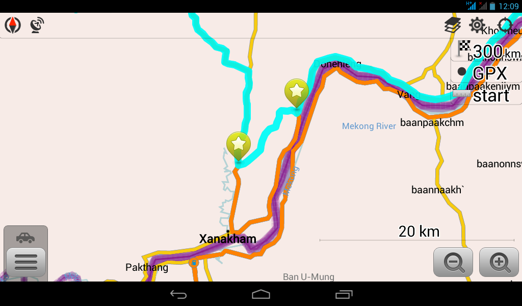
Gnasher, I assume you refer to the part between the two stars and yes, I did this part and it was plain sailing - bit dusty but otherwise no problems.
 
Good to have alternatives to the farce that we bikers are now facing at Chiang Khong.
 
Hi and thanks for the interesting post!
I have a question if i may?
Myself and a mate are renting a pair of CRF250L's, in April, from Jim at Remote Asia Travel in Vientiane.
My planned route for Day 1 of our trip is from Vientiane to Pak Lay via Kenthao. In your post you mention that Road 11 along the Mekong river from Vientiane to Ban Thanasa is being paved. Is is still dirt thereon? I am hoping we can ride as much dirt as possible!
Thanking you in advance.
Andy.
 
Vientiane to Nam Hi/Vang will be more or less paved but after Nam Hi/Vang it will be unpaved (rocky with dirt) till you reach Xanakham (keep following the Mekong river). From Xanakham to Kenthao is unpaved but then from Kenthao to Paklay is paved.

Another option is to follow the Mekong once you cross the Mekong by Ferry at Ban Veunkham and you will have dirt roads almost all the way to Paklay
 
I found the main unpaved roads quite unpleasant due to the choking blinding dust. Seems better to try using paved main roads if possible and save the dirt riding for the quieter backroads. For example the 13N is vile, while the 1C via Vieng Kham and Viangthong was fun.
There is a great dirt road running West @ 18km South of VK towards Luang Prabang via a small village Paxeng where there is a guest house, one of the best roads I found there.
 
Lone Rider / Gnasher328.......
Many thanks for your replies.
@LoneRider - Your "Another Option" was the route I had planned - however I am now thinking that I may head north out of Xanakham on route 11 to Pak Lay.
@Gnasher328 - Thanks, the 13 has never been in my schedule and, funnily enough, both the road through Pakxeng and the 1C are already on my schedule.

Does anyone know the condition of the 3610/3609 from Paklay to Muang Phiang through the Nam Pouy National Park?

Thanks Again!
Andy
 
Does anyone know the condition of the 3610/3609 from Paklay to Muang Phiang through the Nam Pouy National Park?

Thanks Again!
Andy

See part 2 of this same post as I took this road during my trip. Beautiful area and the tracks have been upgraded but expect at places a lot of the very fine powdery stuff.
 
@lone rider...... thanks. Looks good! Looking forward to April!
Andy.
 
Back
Top Bottom