Top 5 dodgy roads.... that you’re not really supposed to be on

Shane

Active member
Joined
May 25, 2019
Location
Chiang Mai
Bikes
Honda Africa Twin, Honda CRF250L
6C78ACED-4407-4E77-9564-FE9DC3A62865.jpeg

C54ABBB1-D0EA-4267-B6D1-EAF37E01F171.jpeg


A4F83B43-22C4-4AD0-A9B4-EEC3A4B9B1AE.jpeg


Top 5 dodgy roads.... that you’re not really supposed to be on


I thought I'd just put this report together for a bit of fun. This small list is really only the tip of the iceberg. There’s many more dodgy roads in the vicinity of northern Thailand and the Golden Triangle. In fact it would be cool if other people added to it.


The below list are roads that I have personally been on. I have put them in order of dodginess.


The dodginess is ranked on the below criteria:

  • Dodgy and dangerous road conditions
  • Regions with a dodgy history
  • Dodgy porous borders
  • Crossing said borders
  • Militia and warlord held areas


I suppose it comes as no surprise that most of these roads are in the Golden Triangle region along the border of Myanmar.


(**Disclaimer: Most of these trips were in 2019. Before covid and the unfortunate situation in Myanmar. At he time of writing this report in January 2022, some of these areas are likely no go zones. Some of them involved crossing unofficial borders. I always asked the soldiers/militia for permission before entering. Some are currently conflict zones. I don't recommend anyone actually goes there.)

19FEC941-FCE7-4777-B433-674188BCECDC.jpeg


41385B9B-1CAE-4449-BDDB-A9F26BE0B9A6.jpeg


Ban Nor Lae to Fang - Chiang Mai Province


B5363D28-4BF8-4F25-855C-D0EFF0E83BF6.jpeg

This the back way to Doi Ang Kang from Fang. The road skims the border of the Shan State in Myanmar. The general area is a notorious smuggling gateway and brings with it all that goes along with it.


This road is apparently open for a few hours a day but closes from 10am to 4pm. Apparently they used to only allow locals through with foreigners not being allowed. I was on this road back in 2018 when road to Chai Prakhan was closed while repairs were being carried out.


At the time the road conditions were very poor. The roads was all torn up, very gravelly and had huge potholes. To top it off, it was super steep too. Not for the feint hearted.


It has super cool views overlooking the Shan State and according to google maps you slightly cross over.


I’ve since been back in the area and it looks like the roads has been fully resurfaced. Apparently they let foreigners through these days between the designated times.


Kinda takes the fun out of it but hey, it’s still a cool ride.


This is probably the tamest of the lot.

B5363D28-4BF8-4F25-855C-D0EFF0E83BF6.jpeg

The road in 2018

BAE881AA-3E7F-4507-BAB2-0ACB785DCCC5.jpeg


Fresh tarmac as of 2021

8F74699D-97E4-41DF-AB49-6837F79B143F.jpeg
C4DEA5EF-6A1A-4017-98B7-103535A701D8.jpeg


233E36E6-C663-4A9B-B9A9-2CF318AAFB1B.jpeg

8DB9B5FB-BA96-428C-A85E-B14BED254C45.jpeg

D5736B2C-C58A-4F7C-9271-B5987ABCC60D.jpeg

A4F83B43-22C4-4AD0-A9B4-EEC3A4B9B1AE.jpeg


Doi Lang - Chiang Mai Province


3B71D712-6050-41DF-911D-4F4489397BB6.jpeg


The road up to Doi Lang is possible one of the sketchiest roads that I’ve been on. It’s super steep and is in absolute bits. It was “paved” at some stage but the lick of tarmac has long since eroded away, leaving behind lose gravel and ruts with sharp edges. There are sections of the road that have fallen away too leaving huge holes. I had a hard job getting the heavy Africa Twin up that mountain without taking a fall. Pretty nerve racking as it was my first time taking the big bike off-road.


The area around Doi Lang has a lot of history and a disputed border. Warlords are traffickers were and possibly still are prevalent close by.


The road itself pretty much is the border of Burma and according to google maps crosses over.


The entry point is near Tha Ton in the very north of Chiang Mai province. It is possible to continue along the Burmese border and pop out near Fang.


There is a military checkpoint about half way. I got grilled there for a good few minutes and they check all my bags. It took a lot of persuasion for them to let me through.


I eventually made it through. Cool ride through a cool area.


3B71D712-6050-41DF-911D-4F4489397BB6.jpeg

994D8E19-4F0D-4598-B00B-81BC924DB811.jpeg

7A617118-1118-4DDB-9957-6141244DB224.jpeg


C6582BD9-2944-4BFD-95BA-E8792ECF0529.jpeg

A2A48888-6525-40AC-B197-A7B47D84EB62.jpeg
B9F96436-9DD5-46EF-9BD1-836EAC034BC1.jpeg
8D316549-D979-405A-A3B1-748FB94A56EB.jpeg

8D316549-D979-405A-A3B1-748FB94A56EB.jpeg
58A1D18F-A7E4-44B8-A444-1B68304D98CF.jpeg

A7FCBA62-780A-4265-8504-6F8977DF5A54.jpeg
579DCAC6-DD12-47A3-BD62-7A72E51050FA.jpeg
3BCB52B4-3208-45AC-9F9B-17DA3B59F46B.jpeg
02C71950-E140-4758-A4CC-B0723FC3BAF3.jpeg
BCB00E1C-07E5-4DFF-BC53-19F80721ADD9.jpeg
DF240893-6DCE-44D8-BBBE-F5221D9421C1.jpeg

88596DE2-E90C-4DF2-9023-37FE7D4557F4.jpeg

B109831F-09B3-4A1F-82D6-6F3451549EAE.jpeg

A707DC5F-AE17-45B9-996A-4062279CE5E6.jpeg
40C3C8D9-368D-4AF9-8619-07B903FC3028.jpeg
5D0EB68B-6BED-476A-B002-149E59DF059A.jpeg

47EB14CA-0235-4330-895C-A9C97D3755BD.jpeg
F9CAC452-AE59-415F-9FD6-AC8DBCCBE236.jpeg


Loi Tai Leng - Burma - Shan State/Mae Hong Son

BBC3276E-7A78-41DD-825B-F831DBE0439F.jpeg


Loy Tai Leng is the army base of the Shan Liberation Army. They seem to be at loggerheads with the Burmese army. They hold military parades and a huge festival there every year during Shan new year.


This base is like a huge sprawling series of villages or like a small town. It’s stretched out over several mountain peaks and ridges. It’s got military bases, lookout towers, gun positions, shops, schools.... and a very large standing army. Until recently it didn’t even show up on google maps.


The day I went there, I went off-road to get around one of the Thai military checkpoints, which stopped me on a previous attempt, and popped out at the village of Baan Bang Kam. From there I headed straight up to the King Naresuan Monument. This road is a broken dirt road and best tackled on a dirt bike or Humvee.


I had to tell the Thai soldiers at a bunch of checkpoints that I was just going to the statue and viewpoint. After taking a few snaps, I thought, well why not roll on down and check out the border.


As I rode to the border checkpoint I could see the Shan Flags. Usually in these circumstances I have my BS excuses in Thai well rehearsed in my head to blag my way through. However this time I was a bit nervous as I would be crossing a border with no visa, passport, etc. I didn’t want to get in trouble and get locked up in the middle of nowhere.


I was super surprised that the guard just raised the barrier for me. I explained that I had no passport, visa etc. No problem, he just waived me through. Well, I wasn’t going to look a gift horse in the mouth, so I rode on in.


I continued to ride along the dirt roads connecting all the mountain army bases. Every checkpoint I went to, they kept letting me through. I guess it was my lucky day.


The Shan guys just seemed to be happy that I had bothered to come visit. I chatted with some of the soldiers and shop keepers.


Loy Tai Leng is located on the Burmese side to the north of Pai. Take the 1226 go past Baan Jabo and straight on to Baan Bang Kam (if the Thai army let you - if not you gotta go off-road around them). After that it’s a rough dirt road north to the border.


Epic ride, awesome scenery, cool army base. 10 out of 10.

DA3F3132-FCE3-4488-A1FE-F832FBD25F24.jpeg

BBC3276E-7A78-41DD-825B-F831DBE0439F.jpeg

A171D334-1710-4FF7-A7E0-6AFB46714E5B.jpeg9E326F81-4617-4D44-A743-1679CA2FF6E3.jpeg

FAD9A7DD-08DE-42DC-983F-31D624E28A01.jpeg
F885345C-71D5-467D-BED4-50B46F8C5513.jpeg

B8322750-8C6C-4446-8202-1CE564A9ECED.jpeg491E2561-6BD2-4FAF-BFBC-546B9E8D18B8.jpeg55C24816-39EC-4680-8B9E-871B696284F3.jpeg6AD191CE-2014-470D-A346-672987FD088F.jpeg64851D25-C721-4D76-BE60-AD92BECB8BB0.jpeg
AC57866A-241C-4FD8-94A2-34D8ACCA54BE.jpeg
3C37F7AB-AD54-4169-AC64-44E61CBFFA82.jpegCA8637A9-316F-4EEF-81EF-2C23F2A71318.jpegECC5A309-2034-4025-BC86-C45EAC59D1F4.jpegB70746A9-9EF7-4EE8-A6ED-28484779758C.jpeg
8A73FBA5-19B1-4378-A20F-822D8B79D576.jpeg
49401376-CEAB-42BA-8CAC-CEE495B277D4.jpeg8382FE78-4BA1-45C2-AA71-EF89D5CA6EC4.jpegF79006D8-05C4-4B3F-B839-5101029A598F.jpeg6DC00AFE-C091-48F4-8241-AD8934E86919.jpegC87F36C0-5EF0-4AA2-9094-6CCAA412FC3F.jpeg23A9FD4A-8F14-4717-BAD3-F817A1D67772.jpegC56789F5-8CFB-47D0-8B82-59F11FE80E92.jpegFFA0F119-26E4-4BD4-8F24-869435FDCD94.jpegC85059DA-A819-4CD8-8CFB-4D43C5ADC401.jpeg
C6BCD4EF-DFD2-4216-8B10-410A7C0B5312.jpeg
8029089A-637A-4266-B053-84D79C674310.jpeg0015ABCD-B41E-4A6A-8F87-0D9E91FA00A3.jpeg1BC5B908-9238-48D1-94FD-59E23D72CDCA.jpeg


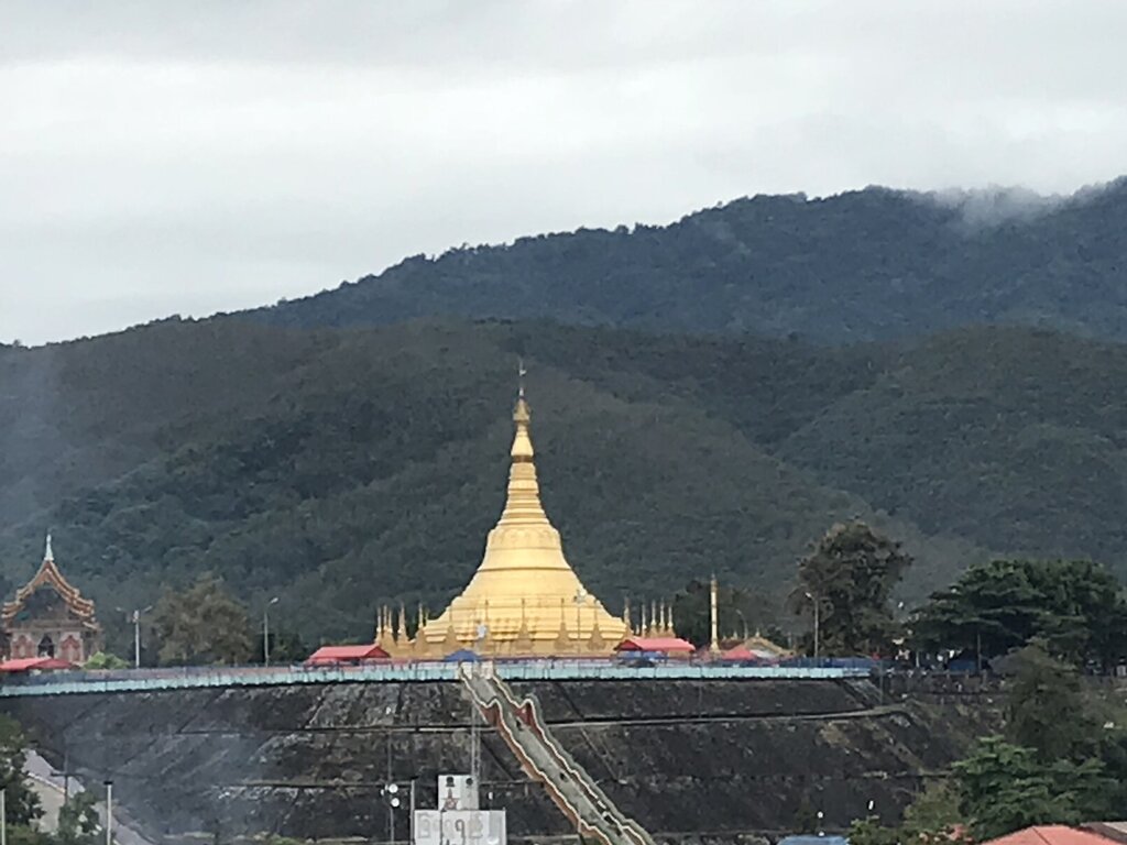
The Paradise Casino - Golden Triangle - Tachileik/ Burma/Chiang Rai


E593F47E-75FF-4D9D-B431-E2D50EC1CFFD.jpeg


Off the beaten track Golden Triangle visit to the Myanmar side.....

For those that have visited the Golden Triangle Park on the Thai side, they can easily see the monstrosity of the Kings Roman casino on the Laos side. You can also rock up there no problem if you feel like a detour.

But have you ever wondered what was on the Myanmar side....?

In the feint distance from the GT Park I could see a large building. I asked the immigration officer a few years prior who told me there was another casino but no Farangs allowed. Having been told it was impossible, My curious side felt compelled to check it out...

In 2018 I crossed the border at Mae Sai to Tachileck. Drove out the road that heads west along the border toward the Golden Triangle area. Got stopped at about 5 check points along the way. Each looked more surprised than the next to see a 2 farangs on big bikes. Each initially said no, but after pleading our case that we just wanted to see the Golden Triangle from the Myanmar side, they eventually let us through. Oddly the actual road to the casino resort was a 2KM dirt track. Eventually, there it was, the “Paradise Casino” in all its glory. The casino itself sure ain’t Vegas! A crumbling relic of times gone by. With some equally crumbling relic clientele. We also stood on the boat landing spot that you can see only a few meters away from the Thai side.


Interesting to see the Golden Triangle from the Myanmar Side.


A very strange journey to a very strange place...

5F8FB589-1B6D-49A7-8541-A92D8025DF3A.jpeg
1631B2C3-D8EB-415F-AB82-5C10B42837F6.jpeg
91F648F8-8174-4480-B54B-92EC770EF021.jpeg40E1F892-A0A0-4DD1-8D3F-847BDA4DDC78.jpeg48D119B1-BED6-46ED-9A37-6EDBDA76F1B3.jpegE8E30C08-0010-471A-8B39-1BA3379FB0C0.jpeg
AA8F13AF-F0C7-477D-B250-C35F279DB130.jpeg
0BC7020F-966B-4A78-BF22-F749DBC7286F.jpeg
A688EBE1-5550-42E0-AEF4-2D4F42E83E7C.jpeg362ED773-F22F-4D0B-8D56-F7D9E8B6B558.jpeg
F890BC05-8625-4597-ACB2-2645EAB5EF81.jpeg
149A4381-9AF9-45B6-9DC6-9CAAF8DDBF2C.jpeg10E32D60-A79D-48F8-BF6A-BD08FBB87EAB.jpeg22C0EEDD-64D5-43E8-8500-04993839BD40.jpeg
43082F7C-C417-4703-B195-78AA8484B35D.jpeg
279FF3EC-45F1-437B-B9C9-2C2737D33AEC.jpeg52A8A8FE-F8E0-43C4-A971-8CDA3C329C01.jpeg

Absolutely stunning countryside around Tachileik in the Shan State.

71AAB9B3-4982-4049-90F4-28096CE0FFA0.jpeg585262E0-9495-434F-8D5B-E70FAE7FE88E.jpeg
EDC62B93-A288-4A34-B164-85636644562F.jpeg
39690FE8-A476-4413-A990-C0DAED1D78EB.jpeg
C4589B02-A3C4-42AC-96E7-32195E2598D5.jpeg


EDC62B93-A288-4A34-B164-85636644562F.jpegA16524EF-456E-4A22-98D0-22579B166129.jpeg

E593F47E-75FF-4D9D-B431-E2D50EC1CFFD.jpeg


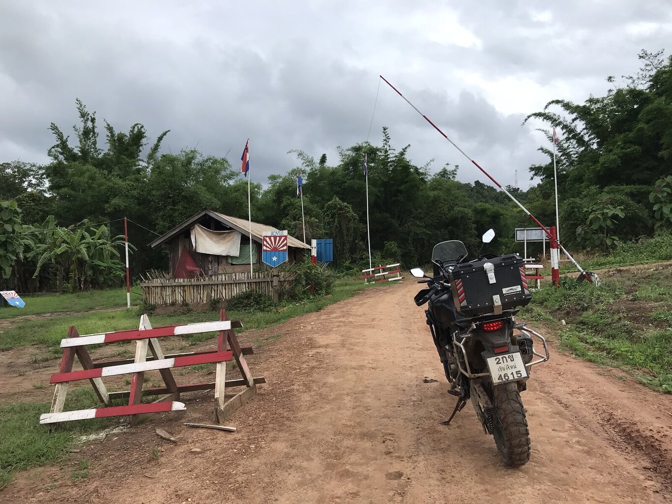
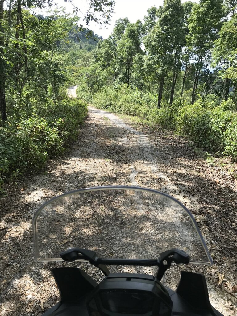
Umphang to Waw Lay - Karen state - Tak/Burma

41385B9B-1CAE-4449-BDDB-A9F26BE0B9A6.jpeg


My trip to the Karen state in Myanmar was a tad accidental and somewhat opportunistic. However it turned out to be quite the adventure and a very interesting experience. I crossed into Myanmar a few times over the course of a few days. I discovered that there are many border crossings throughout Western Tak, both over land and river. To my surprise I didn't encounter any issues crossing into the Karen State as a foreigner.


The next day I intended riding south of Umpang all the way to the end of route 1288. However I missed my turn at one point and found myself back at the Myanmar border. I came across the below KNU Karen army checkpoint. I though I'd try having a chat with the soldiers to see if it was possible for me to proceed. At this point I just wanted to see if it was possible to come back another day as I was planning on turning around and heading back to where I had originally planned.


I had a chat with them for a bit, told them the road looked like fun and that I was keen to have a look around. The told me I could proceed no problems. Not only did they not care, they pretty much invited me to come in. I told them I had no visa or anything. That didn't matter. I also asked if there were other checkpoints further down the road and whether they were Karen army or Burmese. They told me there were some but it wouldn't be a problem. They also told me there were some Burmese checkpoints but that too shouldn't be a problem.


I genuinely hadn't intended on making this detour, but I thought I shouldn't look a gift horse in the mouth. There was also a break in the weather. I thought I might as well make the most of the dry spell and the invite. So I scrapped my other plan for the day and pushed on into the Karen State.


All up this was a really cool little trip into the Karen State. In total, I rode about 80km on the Myanmar side. This route took me almost halfway from Umpang to Mae Sot/Myawaddy on the Myanmar side. It's a place that you don't really hear much about.


There's actually a lot more to this particular story.... so much so that I'll post it in another report.


88F8F320-D873-408A-BF7C-704160755C15.jpeg
907484D3-2567-4D1D-8D5D-A5C2568842CD.jpeg
C042A132-DC9A-4306-8378-65865234B83D.jpeg
BEF36707-6188-4758-A597-4CEF5AA50EEE.jpeg
EFC99CF8-D7BD-4E02-8163-9E37842E8079.jpeg
BFF237B5-B22A-441E-9DA1-45724B8A85C5.jpeg
E27CCD9E-D5D1-4C61-9EB2-B1B4B4C1D651.jpeg
4F3D0192-DB69-4875-801A-657DB9822FCA.jpegA9A89658-30B0-438E-9F62-9FED421668E2.jpeg
2D538631-D957-49CC-911B-417D1BEF943A.jpeg


818143D1-BAE3-4D1E-8D3C-D68F18D6D219.jpeg


Conclusion

No risk no reward. Having said that it’s best to check out what the situation is and try to get some sort of permission. I traveled to these areas around 2018 and 2019, long before Covid and the military coup. As at the time of writing this report in January 2022, I reckon these areas will be off limits for quite some time.


There’s gotta be a few other big ticket good ones out there too like:

  • The missing link
  • Mon state
  • Mong La
  • Lots of other places next to the Shan, Kayan and Karen states too
If anyone has some good stories of dodgy routes, please add them :)
 

Attachments

  • 02D31AF5-B25C-44C1-9808-B63060F99C63.jpeg
    02D31AF5-B25C-44C1-9808-B63060F99C63.jpeg
    462 KB · Views: 153
  • 55BB8B10-715A-409B-A542-AF0FA659DC82.jpeg
    55BB8B10-715A-409B-A542-AF0FA659DC82.jpeg
    806.4 KB · Views: 119
  • DAC13E35-BC0B-4679-B0C9-32B3F62C0FEB.jpeg
    DAC13E35-BC0B-4679-B0C9-32B3F62C0FEB.jpeg
    187 KB · Views: 122
Last edited:
Great report, thanks Shane.

"Missing Link" you say?

Yes, I'd love to do it again but I suspect they will keep us out of there for a long time to come. Two main reasons - the military coup in Burma and the tiger population. Thailand is reportedly the only country to have increased it's wild tiger population. Just last week though, some poachers, a bit south of the Missing Link, were arrested - having killed two tigers. I hope I'm wrong - but in the meantime - here's me taking a pic of Bob Kelly as we crossed back. That's Burma on the far bank.

i-7jP6Df2-X3.jpg


Update - here's the tiger pelts that were recovered last week, in the Thong Pha Phum National Park in Kanchanaburi - its the same sort of territory as the Missing Link ride (Sangkhlaburi to Umphang)

tigerpoachers-XL.jpg


I've only ever seen one in the wild - whilst on a night birdwatching trip with a guide in the Way Kambas National Park in southern Sumatra. We'd seen it just off the road - stunningly bright eyes - and a kilometer further up the road, the guide finally got one of the birds to respond to the calls he was playing on a speaker. "Come... we go" - "What about the tiger?" "They no eat anyone here, only up in Aceh" - where apparently they do eat half a dozen or so people every year. Anyhow, five minutes later, we're 100 metres down the road and 150 metres into the jungle - and I get a couple of shots of the world's largest frogmouth. "OK, we go" - "You not want more photos?" No.

161gjjjjcxff-X2.jpg


Shitty photo... but so what. The day before, I'd been told it was OK to ride through an elephant camp. Turns out these are all the wild bulls in the area that have been captured because they've caused trouble.

061zdsfh%20-%20Copy-X3.jpg


That was my first real experience with elephants - as I was riding up from Australia to the China border. As most readers here would know, it turns out that the adolescent bulls are the dangerous ones. I hand fed three of them in that camp. The third one decided to kill me. This is him telling me he was going to do it.

073dfh-X2.jpg


He started to stab my thigh (I was on the bike, engine off) with his right tusk, but I was able to get my leg away from the tusk - but it was trapped between the tusks. You've never felt brute force like a two ton elephant. He tossed the bike and me about 3 metres.... then he claimed the bike

thrown-X2.jpg


... and here's what tiger footprints look like. I saw these in the jungle in Malaysia, chasing down a Rafflesia

107fghhhhrr-X2.jpg


I suspect that these falls are still reachable - at the northern end of the Missing Link.

i-N5wvrMv-X4.jpg


That "dodgy road" starts just north of here:

i-PcqpjX4-X4.jpg


There's not much of a trail in parts

i-D8Bm74g-X2.jpg


i-pKv68gX-X2.jpg


i-pWzW3Kz-X4.jpg


In some places, we rode the creek beds, as there was no track. Every time we saw a local, we stopped to find out news of the Burmese Army
i-cvMBD2R-X2.jpg


Here's one that involved a lot of border crossings. In a five week period, I did 29 land border crossings - between Cambodia, Thailand and Myanmar, according to my GPS - for one stamp in the passport. Technically, this one below isn't a dodgy road - but some aspects of the trip were.

i-9Pf6HnW-X2-X2.jpg


That's Pol Pot's cremation / burial site. The dodgy part it trying to piss on the mass murderer's grave with an armed guard just 50 metres away. He's still a popular man among some locals.

i-F9zHsRC-X2-X2.jpg


Getting to his house site was a bit dodgy. We almost ended up in a hidden gun pit - and we were followed in by a couple of soldiers, but they proved friendly. We pulled up just short of this

00cambo3a-X2.jpg


i-2RBfdrH-X3-X2.jpg


Plenty of border crossings in that one

thaicamb%20border-L.jpg
 
Last edited:
Great write up mate and great photos as well. That trip into Burma well past the border in Umphang was extremely interesting!👍👍👍
 
A bit more on the Missing Link. I've edited my earlier post to include more, but here's a bit of the GPS graph

i-DXZHfjW-M.jpg


Same area, a couple more points highlighted

i-bf8Rbh7-M.jpg


It's not big bike territory.

Here's our bikes. At a guess I'd say two of them are in Thailand and three of them in Myanmar

i-xRKSx58-X4.jpg


I believe we were the first bikes through after the wet season - and we had to clear fallen bamboo etc from some of the trails

i-wCp8nRs-X2.jpg


Dodgy photo, but it's a dodgy roads thread... and when no-one has been through a creek crossing for 7 months or so, the algae can build up and its as slippery as a KY spill

i-TWbM2rS-X4.jpg


We lost time clearing drowned bikes too

i-xfH9WtJ-X4.jpg


Day 2 saw us make less than 44 km in just over 8 hours.

Since then, people have been getting turned back, I believe. I'd love to do it again when it opens up.
 
Here's one of the dodgiest roads I've ridden. Its the final bit of the road out from Hongsa to Ban Houayxong in Laos. 18 months before, we had done this newly built road in company with a two wheel drive ute. The Laos government had tried for aid funding to build it, but was told that it wouldn't last. It didn't.

The Mekong River is 120 metres straight down over the edge here

mekong%20ride%20combined-X3.jpg


This is the same spot the day before, heading in to the village

mekong%20ride%20shot%20other%20way-X3.jpg


So nice of them to put a stick or two there to grab at if you went over.

Here's another one from Laos

00sphincter1a-X2.jpg


That dark patch had me worried - it showed that the area was still collapsing - the dark patch being moisture that hadn't dried out yet, so it had just fallen. It was a sphincter tightener.

Speaking of dark patches.... nothing dodgy about this road - except the depth of the potholes. Pulling a mate's bike out - it'd been totally submerged. I'd gone through first - spotted the hole and just missed it by centimetres.

DSCN6911a-X2.jpg


One from the Bromo volcano - which had erupted just a few months before. If the horses can do it, I can do it. The tourists were a bit pissed off with me... but hey, equal rights and all

0A9-X3.jpg


The only dodgy thing about this road in Timor Leste - apart from a few big boulders - was Old Mate. He'd never been on a big bike before and when I started to use a bit of power... he cracked a boner. Sorry mate... you're not my type - but I did get a shot of his grin.

246vcm-X2.jpg
 
Great stuff!

I've driven the Nong Luang to Waley "shortcut". Came the normal way from Tak to Umphang and surrounds, then on the way back, drove the "Burmese shortcut".

Did it all in one long day, but by SUV (not by bike) with several Chinese colleagues.

Had heard about it for years and after reassurances it was accessible (it had been briefly closed on several occasions since 2013, due to various "disputes", including one time when the Burmese (or Karen?) were "unhappy" about all the Thai vehicles using the route, a strange excuse but that was what it said in the Thai news) I decided to give it a go. Not sure when it originally "opened" I understand around 2012 or 2013. Before then the security situation probably didn't permit it (or there might not even have been a track....not sure).

Met a friendly Thai soldier jogging just before Nong Luang, asked him to confirm it was fine to cross and he said it was.

Had to pay 100 Baht at the first checkpoint. The Thai speaking Karen guy (who could also speak a little English) told me to keep right (which I knew, but there was no marked switchover point) and that there was a 2nd checkpoint where I would pay another 100 Baht.

Most of the road is being paved over with concrete (could be finished by now), but it won't help anyone trying to cross back into the Thai Waley village by car (or motorcycle) during the rainy season as there is no vehicular bridge over the river. Therefore, this shortcut will continue to be accessible for cars only between roughly November and May (or early June) of each year.

There is also a footbridge that can freely be crossed by anyone from the Thai Waley to the Burmese Waley, between 6am and 6pm daily. Soldiers take your photograph, but you can cross without payment or any documentation required.

You can access Mulayit Taung, a 2000m high mountain with a monastery on top where you can camp, which is quite popular with Thais, by crossing over at Nong Luang or Waley. I watched a YouTube video about some Thai riders going over in January 2020 and they did some "paperwork" - not sure why or who to contact about that. I don't think that is needed for Mulayit - when the border is open you just show up and cross. Obviously it helps if you know how to get there - you'll need a good GPS, a knowledge of Burmese or a local to guide you (or simply an adventurous spirit). Plenty of locals speak Thai, hence if you can't speak Burmese or Karen, a knowledge of Thai should get you there too.

I used the Nong Luang to Waley road in early 2019.

Due to Covid, I'm quite sure all of these crossings are currently off-limits and the recent violence in the region is probably an additional reason why no one is likely to be allowed into or out of Myanmar by land for some time to come. Once Covid restrictions are lifted, there is a good chance access will be permitted again but then the security situation might still play a role.
 
I'm curious about the procedures you used to temporarily bring in your bikes at Tachilek.

I understand this is a fairly straightforward procedure - I've looked it up online and even asked a Thai customs officer in Mae Sai when I was last up there in 2018. However, since 2012 or so, the Burmese authorities have tightened things up, no longer allowing vehicles to freely travel up to Kengtung or Mong La without a guide or tour.

Apparently since then, your vehicle can enter for 1 or 7 days, but is not officially allowed to leave Tachilek. Am I correct?

The normal exit paperwork applies on the Thai side, which can take a little while. You're supposed to park your vehicle somewhere before customs and then present your green book (for motorcycles) or blue book (for cars) where they will print out a customs form and also issue separate immigration TM2/TM3/TM4 forms. At some border checkpoints, they type all the required information up for you, then you simply sign it, at others (such as Mae Sot, Tak), you fill out the forms yourself (in duplicate, meaning writing largely the same info on 6 pages) and then hand that in to immigration.

In Myawaddy, you pay 20 Baht (sometimes it's free) and receive a large "Myanmar immigration" plastic plate you carry with you but can only drive around town or in an approx. 12km radius during the day, returning to the Thai side before the bridge closes for the day.

Is the procedure the same at Tachilek? If not, how did it differ?

I know the immigration procedure is the same - you stamp out from the Thai side, then pay US$10 or 500 Baht at the Myanmar side. One difference in Tachilek being the option of a 14 day pass, whereas in Myawaddy, without a visa your only option is a day pass.
 
If you mean the "missing link" between Sangkhlaburi and Umphang, that runs entirely through Thai territory. Unless the Thai or Kanchanaburi/Tak provincial government(s) stupidly close the national park(s) that run through the area due to "Covid" again, then there is no reason why anyone would be prevented from accessing that corridor, unless it has something to do with conservation or tigers. Certainly won't have anything to do with fighting on the Burmese side. Thailand is completely safe (excepting the 3 southernmost provinces) and foreigners are pretty much permitted to roam the entire country.
 
If you mean the "missing link" between Sangkhlaburi and Umphang, that runs entirely through Thai territory. Unless the Thai or Kanchanaburi/Tak provincial government(s) stupidly close the national park(s) that run through the area due to "Covid" again, then there is no reason why anyone would be prevented from accessing that corridor, unless it has something to do with conservation or tigers. Certainly won't have anything to do with fighting on the Burmese side. Thailand is completely safe (excepting the 3 southernmost provinces) and foreigners are pretty much permitted to roam the entire country.

We went a fair way into Burma on the Missing Link ride. There were Karen guys on the Thai side wandering around with military weapons - and every time we met a local, we asked what was going on with the Burmese Army "8km that way" etc. The tiger conservation side of it is gaining in importance and its been noted that Thailand is the only country where the wild tiger population is increasing. Consular officials have warned to stay out of the area due to the military conflict though....
 
On a separate note - I've got some video footage to edit of a ride from Mae Sai along the border to the west - including some trails not shown on Google Maps... as far as Ban Pa Sang Na, before heading south. No others on the last part of that trail, except multiple army checkpoints. The trails cross the border a few times, it seems. I will probably keep that as big screen video in the restaurant, rather than putting it on the web.

 
We went a fair way into Burma on the Missing Link ride. There were Karen guys on the Thai side wandering around with military weapons - and every time we met a local, we asked what was going on with the Burmese Army "8km that way" etc. The tiger conservation side of it is gaining in importance and its been noted that Thailand is the only country where the wild tiger population is increasing. Consular officials have warned to stay out of the area due to the military conflict though....
As long as you don't cross into Myanmar/Burma then all is well.

Is there a trail that goes into Myanmar from there?
 
That looks absolutely epic! definitely high up on my "to do" list :)

That pic of the bikes on the barely floating raft is a classic!

Could be a while before that one opens back up again. Will have to keep an ear to the ground for when it's doable again.

Great report, thanks Shane.

"Missing Link" you say?

Yes, I'd love to do it again but I suspect they will keep us out of there for a long time to come. Two main reasons - the military coup in Burma and the tiger population. Thailand is reportedly the only country to have increased it's wild tiger population. Just last week though, some poachers, a bit south of the Missing Link, were arrested - having killed two tigers. I hope I'm wrong - but in the meantime - here's me taking a pic of Bob Kelly as we crossed back. That's Burma on the far bank.

i-7jP6Df2-X3.jpg


Update - here's the tiger pelts that were recovered last week, in the Thong Pha Phum National Park in Kanchanaburi - its the same sort of territory as the Missing Link ride (Sangkhlaburi to Umphang)

tigerpoachers-XL.jpg


I've only ever seen one in the wild - whilst on a night birdwatching trip with a guide in the Way Kambas National Park in southern Sumatra. We'd seen it just off the road - stunningly bright eyes - and a kilometer further up the road, the guide finally got one of the birds to respond to the calls he was playing on a speaker. "Come... we go" - "What about the tiger?" "They no eat anyone here, only up in Aceh" - where apparently they do eat half a dozen or so people every year. Anyhow, five minutes later, we're 100 metres down the road and 150 metres into the jungle - and I get a couple of shots of the world's largest frogmouth. "OK, we go" - "You not want more photos?" No.

161gjjjjcxff-X2.jpg


Shitty photo... but so what. The day before, I'd been told it was OK to ride through an elephant camp. Turns out these are all the wild bulls in the area that have been captured because they've caused trouble.

061zdsfh%20-%20Copy-X3.jpg


That was my first real experience with elephants - as I was riding up from Australia to the China border. As most readers here would know, it turns out that the adolescent bulls are the dangerous ones. I hand fed three of them in that camp. The third one decided to kill me. This is him telling me he was going to do it.

073dfh-X2.jpg


He started to stab my thigh (I was on the bike, engine off) with his right tusk, but I was able to get my leg away from the tusk - but it was trapped between the tusks. You've never felt brute force like a two ton elephant. He tossed the bike and me about 3 metres.... then he claimed the bike

thrown-X2.jpg


... and here's what tiger footprints look like. I saw these in the jungle in Malaysia, chasing down a Rafflesia

107fghhhhrr-X2.jpg


I suspect that these falls are still reachable - at the northern end of the Missing Link.

i-N5wvrMv-X4.jpg


That "dodgy road" starts just north of here:

i-PcqpjX4-X4.jpg


There's not much of a trail in parts

i-D8Bm74g-X2.jpg


i-pKv68gX-X2.jpg


i-pWzW3Kz-X4.jpg


In some places, we rode the creek beds, as there was no track. Every time we saw a local, we stopped to find out news of the Burmese Army
i-cvMBD2R-X2.jpg


Here's one that involved a lot of border crossings. In a five week period, I did 29 land border crossings - between Cambodia, Thailand and Myanmar, according to my GPS - for one stamp in the passport. Technically, this one below isn't a dodgy road - but some aspects of the trip were.

i-9Pf6HnW-X2-X2.jpg


That's Pol Pot's cremation / burial site. The dodgy part it trying to piss on the mass murderer's grave with an armed guard just 50 metres away. He's still a popular man among some locals.

i-F9zHsRC-X2-X2.jpg


Getting to his house site was a bit dodgy. We almost ended up in a hidden gun pit - and we were followed in by a couple of soldiers, but they proved friendly. We pulled up just short of this

00cambo3a-X2.jpg


i-2RBfdrH-X3-X2.jpg


Plenty of border crossings in that one

thaicamb%20border-L.jpg
 
Thanks mate.

Yeh, Mulayit is high on my to do list. When I was in Waw Lay some locals told me about it. After I got back I did a bit of research on it. Seems like a a good few Thai youtubers have been there. It looks awesome in their videos.

I was also told there is a cool waterfall there called Su Ka Li. Might be worth checking out next time too.

Both are on maps.me so easy enough to find.

It was pretty easy to get around. Pretty much everybody spoke Thai over there. I asked why and was told that many people there had worked in Thailand at some point. I even went to a Thai restaurant for lunch over there lol

Unfortunately at the moment it seems there is fighting taking place close to that region. On top of that I reckon those borders would be shut due to Covid. So gonna have to wait a while before heading back there.

Great stuff!

I've driven the Nong Luang to Waley "shortcut". Came the normal way from Tak to Umphang and surrounds, then on the way back, drove the "Burmese shortcut".

Did it all in one long day, but by SUV (not by bike) with several Chinese colleagues.

Had heard about it for years and after reassurances it was accessible (it had been briefly closed on several occasions since 2013, due to various "disputes", including one time when the Burmese (or Karen?) were "unhappy" about all the Thai vehicles using the route, a strange excuse but that was what it said in the Thai news) I decided to give it a go. Not sure when it originally "opened" I understand around 2012 or 2013. Before then the security situation probably didn't permit it (or there might not even have been a track....not sure).

Met a friendly Thai soldier jogging just before Nong Luang, asked him to confirm it was fine to cross and he said it was.

Had to pay 100 Baht at the first checkpoint. The Thai speaking Karen guy (who could also speak a little English) told me to keep right (which I knew, but there was no marked switchover point) and that there was a 2nd checkpoint where I would pay another 100 Baht.

Most of the road is being paved over with concrete (could be finished by now), but it won't help anyone trying to cross back into the Thai Waley village by car (or motorcycle) during the rainy season as there is no vehicular bridge over the river. Therefore, this shortcut will continue to be accessible for cars only between roughly November and May (or early June) of each year.

There is also a footbridge that can freely be crossed by anyone from the Thai Waley to the Burmese Waley, between 6am and 6pm daily. Soldiers take your photograph, but you can cross without payment or any documentation required.

You can access Mulayit Taung, a 2000m high mountain with a monastery on top where you can camp, which is quite popular with Thais, by crossing over at Nong Luang or Waley. I watched a YouTube video about some Thai riders going over in January 2020 and they did some "paperwork" - not sure why or who to contact about that. I don't think that is needed for Mulayit - when the border is open you just show up and cross. Obviously it helps if you know how to get there - you'll need a good GPS, a knowledge of Burmese or a local to guide you (or simply an adventurous spirit). Plenty of locals speak Thai, hence if you can't speak Burmese or Karen, a knowledge of Thai should get you there too.

I used the Nong Luang to Waley road in early 2019.

Due to Covid, I'm quite sure all of these crossings are currently off-limits and the recent violence in the region is probably an additional reason why no one is likely to be allowed into or out of Myanmar by land for some time to come. Once Covid restrictions are lifted, there is a good chance access will be permitted again but then the security situation might still play a role.
 
I'm curious about the procedures you used to temporarily bring in your bikes at Tachilek.

I understand this is a fairly straightforward procedure - I've looked it up online and even asked a Thai customs officer in Mae Sai when I was last up there in 2018. However, since 2012 or so, the Burmese authorities have tightened things up, no longer allowing vehicles to freely travel up to Kengtung or Mong La without a guide or tour.

Apparently since then, your vehicle can enter for 1 or 7 days, but is not officially allowed to leave Tachilek. Am I correct?

The normal exit paperwork applies on the Thai side, which can take a little while. You're supposed to park your vehicle somewhere before customs and then present your green book (for motorcycles) or blue book (for cars) where they will print out a customs form and also issue separate immigration TM2/TM3/TM4 forms. At some border checkpoints, they type all the required information up for you, then you simply sign it, at others (such as Mae Sot, Tak), you fill out the forms yourself (in duplicate, meaning writing largely the same info on 6 pages) and then hand that in to immigration.

In Myawaddy, you pay 20 Baht (sometimes it's free) and receive a large "Myanmar immigration" plastic plate you carry with you but can only drive around town or in an approx. 12km radius during the day, returning to the Thai side before the bridge closes for the day.

Is the procedure the same at Tachilek? If not, how did it differ?

I know the immigration procedure is the same - you stamp out from the Thai side, then pay US$10 or 500 Baht at the Myanmar side. One difference in Tachilek being the option of a 14 day pass, whereas in Myawaddy, without a visa your only option is a day pass.

I've actually done the Tachileik crossing with a bike twice. It was pretty much just a straight forward temporary vehicle export. Just needed the bike registration book. However they only issue the paperwork for a few days (not 30 days like Laos or Cambodia). No plastic plate or anything like that though.

The Thai side were very nice and helpful. They did all the paperwork for me.

The Burmese side were very friendly too. Spoke great English. On the Burmese side, if you have no Burmese visa (which was my case), you swapped your passport for a "passbook". They keep your passport and return it to you when you leave.

You can only ride around Tachileik, not on up the road to Cheng Tung or Mong La. There is a checkpoint/toll area about 10K outside the town that stops you.

I rode East to the golden triangle. I got stopped about 5 times. The first checkpoint kept my "passbook" as a deposit to make sure I came back. The other checkpoints wanted to do the same, but I had to explain to them that the the first checkpoint had kept it. It was a mission to get through them all, but in the end we made it.

A few years ago I tried to take my bike over at the friendship bridge at Myawaddy. The Thai side at Mae Sot gave me all the exit papers etc and let me go. But when I got to the other side, I was told by the Burmese that I couldn't take my bike around the town. I had to park it up at the bridge and collect it on my way back.

Awesome! Thanks for this write up.

Although I have been to Mae Sai several times in the past few years, the most recent occasion I crossed to Tachilek was all the way back in 2014. The guide I decided to hire for my short tour of the town, a Thai speaker (I'm fluent in Thai) told me they stopped allowing foreign [mainly Thai] vehicles in, who intend to travel further than Tachilek unless they go on an organized tour. This was ostensibly to give the local taxi drivers some business.

I heard rumors that it would be possible to bring in a car and drive freely to Chiang Tung (Kengtung), possibly with a guide that you can hire on the spot, by the time of my next visit to Mae Sai in 2018. I would have been OK with that, even at a price of 1000 Baht a day, as long as you could just show up at the border and hire a guide right there.

A Thai customs official seemed to think I'd be allowed to do that (but to check with the Burmese authorities first). However, when I quizzed a Burmese customs official who came over to Mae Sai for the evening market he couldn't understand much English and kept repeating "come over tomorrow" because it was already around 8.30pm (which is half an hour before the bridge closes). I don't think he understood my intention was to drive myself to Kengtung, not hire a driver. Even gesticulating like Mr. Bean driving a pretend car didn't seem to do the trick.

I didn't actually have time to investigate this though, as the objective of my trip was to travel to eastern Myanmar with my Chinese colleagues via Mae Sot the next day (we had just arrived from Kunming, China via Jinghong and Laos by car...we switched at the Lao/China border to my car, which was parked at Chinese customs and spent the night at Sob Ruak, before ending up in Mae Sai). The Thai official told me they grant permission to take your vehicle out for 7 days at Mae Sai. As you mentioned, it's not 30 days like is the case at nearly all other crossings. 7 days is plenty for a trip to Kengtung/Mong Lar, IF it were allowed. I get the feeling what I was told about hiring a guide on the spot is not doable and was simply a rumor. You still won't be allowed to take your vehicle out of Tachilek even if you agreed to hire a guide. I think heading to the Golden Triangle casino works because it's still in the border area (even if you need to negotiate as you did) but heading north to Kengtung it's probably a flat out no.

I also understand even to just bring your vehicle to Tachilek, you need to arrive without a visa, because if you possess a visa you can then legally travel to other parts of the country, whereas your vehicle (car or motorcycle) can't leave town.

I've driven across the Friendship Bridge at Mae Sot to Myawaddy well over 20 times since 2016. However, I've always gone by car as I understand motorcycles are not allowed across, unless they're going on a tour. There was one time I saw a farang couple with a Chiang Mai registered motorcycle crossing over for the day (and no guide) this must have been around 2017 or 2018, but they were the only motorcycle I've ever seen crossing the bridge who wasn't on a formal tour.
 
Last edited:
Thanks mate.

Yeh, Mulayit is high on my to do list. When I was in Waw Lay some locals told me about it. After I got back I did a bit of research on it. Seems like a a good few Thai youtubers have been there. It looks awesome in their videos.

I was also told there is a cool waterfall there called Su Ka Li. Might be worth checking out next time too.

Both are on maps.me so easy enough to find.

It was pretty easy to get around. Pretty much everybody spoke Thai over there. I asked why and was told that many people there had worked in Thailand at some point. I even went to a Thai restaurant for lunch over there lol

Unfortunately at the moment it seems there is fighting taking place close to that region. On top of that I reckon those borders would be shut due to Covid. So gonna have to wait a while before heading back there.

Plenty of Burmese living in border areas of Myanmar, particularly around Karen/Kayin state speak Thai. In Myawaddy it's 50/50, in places like Waley (the Burmese one) nearly everyone can speak Thai. Apart from Myawaddy, I just speak Thai with everyone and if someone doesn't understand, switch to basic English/Burmese (i speak a few words). In Waley, a group of Karen villagers were having a party and invited me and my group to join in. I spoke Thai with them, my Chinese colleagues of course English. One or two of the villagers spoke a little bit of English but their Thai was far superior.

Mulayit is definitely high on my to do list as soon as borders reopen.

I think Covid is the main obstacle - the Thais won't allow even informal crossings (such as between Nong Luang and Waley) until the state of emergency ends, Myanmar formally reopens and the global situation gets back to near normal. That could potentially occur before the end of this year according to media reports.

Of course, the security situation in the area might keep us out, even once Covid rules are lifted. Anyone who is familiar with Myanmar travel going back a while now knows what I'm talking about. The checkpoints won't let you through if they see a farang and I suspect if there's instability along the border, Thai authorities will revert to only allowing passage to Burmese locals from the immediate surrounding villages, which was the case pre-2013, before the ceasefire in the region was enacted and land borders with Thailand formally opened.

Hence why if there continues to be flare-ups in violence once border restrictions are lifted, we might only be allowed to travel the Myawaddy to Hpa-an corridor, without deviating too much from the main highway. This means no travel south of Mae Htaw Talay (the scene of recent fighting, just to the south of Myawaddy). This is also the route from Myawaddy down to Waley/Mulayit. However, most Thais seeking to access Mulayit would enter via Nong Luang or Waley. Hence if fighting happens in the area, Mulayit will unfortunately be off-limits as you can only access it from either Nong Luang/Waley or Myawaddy. It's not accessible from the west (Mawlamyine).
 
Last edited:
That looks absolutely epic! definitely high up on my "to do" list :)

That pic of the bikes on the barely floating raft is a classic!

Could be a while before that one opens back up again. Will have to keep an ear to the ground for when it's doable again.
I suspect there are several issues at play here.

The main one is Covid and the ever changing rules on entering places, including national parks. Local authorities might not want tourists to travel through the missing link at present. Some of the local villagers in remote areas can also be quite paranoid and absolutely frightened about getting "infected". I've seen in some YouTube videos showing villages near Umphang, which have closed to all outsiders (with guards positioned at the entrance to villages) hence why in my opinion it is unwise to visit such areas (including the "missing link") at this time as it could cause some uncomfortable encounters between locals/foreigners. Other bloggers have shown similar footage from remote villages in Mae Hong Son. SE Asia, including Thailand is a very friendly region, but unfortunately, the local paranoia about Covid particularly in remote areas where education levels are poor, is something we have to be aware of. Best to wait until some semblance of normality returns, then the paranoia will likely disappear.

The aforementioned tigers/conservation issues and potentially, fighting on the Burmese side could also be issues, though the latter is unlikely to be a problem provided you don't actually cross into Burmese territory.
Yeh, I've noticed its hit and miss with the remote villages regarding Covid. Some are massively paranoid and have barricaded the roads. Others don't care at all...
 
Back
Top Bottom