Three15.org Thai Topo Map

AlexUSA

Senior Member
Joined
Apr 19, 2011
Bikes
XR280R, Dash 125 (supercup) , DT125
I'd like to check out this Three15.org topo and I've followed their instructions:

1. Extract (unzip) the contents of the file into:
C:\Garmin\AG1-TH\

2. Incorporate the file AG1-TH.reg into the windows registry by double-clicking it.

But it's not showing in MapSource or Basecamp map product selection.

Anyone ever install this successfully? Any idea if this is a decent topo map?
 
Yes, I have done it without any problems and they show up in Mapsource but you will have to zoom in to see the contour lines.
 
It seems for my computer I needed to use MapSetToolKit and cGPSMapper to manually add the Three 15 map to the registry. I think the reg file they gave me wasn't working. Working now.
 
AlexUSA said:
It seems for my computer I needed to use MapSetToolKit and cGPSMapper to manually add the Three 15 map to the registry. I think the reg file they gave me wasn't working. Working now.


Would be interested in seeing a screen shot of it when you have it
 
I use this map already on my 60csx and (on the GPS unit) I can overlay it with Thailand ESRI and also with North Thailand (although the North Thailand map terrains block out some features of the other maps). The contours are very detailed - I believe this is what they call "research grade" contour lines.

Topographic data is massively useful when riding off tarmac around the mountains and can keep you out of trouble.

This is the first time I've added it to MapSource and unfortunately it's not nearly as helpful as when it's on my GPS as Mapsource only allows you to view one map at a time.

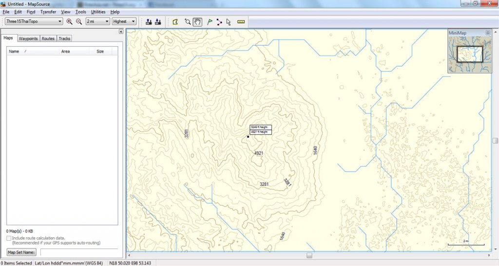
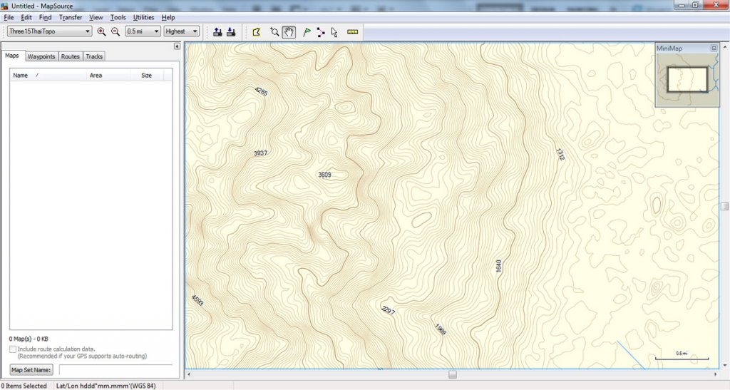
The following images are the mountains West of Chiang Mai at two different zoom levels.

Untitled-1.jpg

Untitled-2.jpg
 
AlexUSA said:
I use this map already on my 60csx and (on the GPS unit) I can overlay it with Thailand ESRI and also with North Thailand (although the North Thailand map terrains block out some features of the other maps). The contours are very detailed - I believe this is what they call "research grade" contour lines.

While it looks like "research grade" it is based on satellite spot measurements at a grid of 90 meters and the contours are evenly spread in between the 90 meters. Or with other words, if there is a dip in between 2 points the map will show a smooth gradient and not the dip. NASA has spot measurements at 30 meter intervalls but unfortunately, these are not made public for areas outside the USA.
 
AlexUSA said:
But it's not showing in MapSource or Basecamp map product selection.

The .reg-file that comes with the map won't work with Windows 7, which might be what caused you problems. If you are using Win 7, the two lines that read

[HKEY_LOCAL_MACHINE\SOFTWARE\Garmin\MapSource\Families\AG1-TH]
and
[HKEY_LOCAL_MACHINE\SOFTWARE\Garmin\MapSource\Families\AG1-TH\2]

should be changed to

[HKEY_LOCAL_MACHINE\SOFTWARE\Wow6432Node\Garmin\MapSource\FamiliesNT\AG1-TH]
and
[HKEY_LOCAL_MACHINE\SOFTWARE\Wow6432Node\Garmin\MapSource\FamiliesNT\AG1-TH\2]

and then it works.

I installed it on my (Win 7) machine, and it works fine in Mapsource. However, when trying to download it to my 60csx, it came up with a dire warning, saying that I am about to erase data that has been pre-programmed by Garmin, and that if I am using an SD-card, this data will be permanently lost. I chickened out as I wasn't quite sure what it was talking about (whether it is just going to delete part of the basemap, which would be OK, or whether it will mess up my ESRI-map, which would be rather annoying). What happened when you did it?
 
On the newer Garmin GPS units (Montana, 62 series, etc.) you can use basically any name for the map and have several maps on the internal memory as well as on the GPS so you can have a map with the name ESRI Thailand.img, Topo Thailand.img, etc.

However, on the older units like the 60 series the maps have to be combined into 1 map with the name gmapsupp.img. There are a few other names possible like gmapprom.img but that is unit specific and a bit tricky. So your ESRI map most probably is named gmapsupp.img and if you send another map from Mapsource with the same (standard) name, the ESRI map will be overwritten and disappear from your GPS.
 
That seems to conflict a bit with what AlexUSA is saying

AlexUSA said:
I use this map already on my 60csx and (on the GPS unit) I can overlay it with Thailand ESRI...

unless he is combining them before sending them to the GPS. If that's the case, I'd like to know how that is done.
 
No, that is not conflicting as AlexUSA has most probably combined the maps into one gmapsupp.img file and on the GPS you can select which maps are shown. If the topo map is made transparent and given a higher priority than the other maps, the topo map will be on top of the other maps and you can see the underlying maps through the transparent topo map.

Should be back in Chiangmai in a day or 10 (now on my way to Vientiane for work) and will then make a write up on how to do it.
 
I am always scared to mention the tools to manipulate maps directly on here as those same tools are very often the ones that strip locks and encoded security. Which for obvious reasons Phil and the mapping contributors are not going to want to see on here.

Google is your friend and GMapTool or MapSetToolkit both can combine img files. Tho I should point out I am not familiar with this topo map so havent tested how it looks combined with other maps.
 
LivinLOS said:
I am always scared to mention the tools to manipulate maps directly on here as those same tools are very often the ones that strip locks and encoded security. Which for obvious reasons Phil and the mapping contributors are not going to want to see on here.

Google is your friend and GMapTool or MapSetToolkit both can combine img files. Tho I should point out I am not familiar with this topo map so havent tested how it looks combined with other maps.

oops, too late.
garmin-mapsource-and-related-information-t352.html
:RE
 
I am aware of the tools that have been mentioned here, and I also know how to unlock and install NT-type maps into Mapsource. My problem here was with the fact that the ESRI-maps - and others - are locked to the unit ID of the GPS, which I am not sure how to deal with. My thinking was that trying to create a new gmapsupp.img would cause problems due to the ID-issue. However, I tried joining the topo-map in question with the ESRI-map and loaded it onto the SD-card, and - somewhat to my surprise - it worked. I also installed it into Mapsource, but it still needs a bit of fine-tuning as all elevation contours are blocked out by regions that denote national parks, cities and so on. I'm guessing that's something to do with the priority of the topo-map needing to be raised, as Lone Rider mentioned.

Also, just to clarify my previous post about installing things into Mapsource on Windows 7: Inserting 'Wow6432Node' into the registry-path is only necessary if you're running a 64-bit version of Win 7. If you're on 32-bit (or if Garmin decides to make a 64-bit version of Mapsource), it won't be necessary. All 32-bit applications that run on Win x64 and store settings in HKEY_LOCAL_MACHINE\Software are redirected to HKEY_LOCAL_MACHINE\Software\Wow6432Node. If, for instance, you use an install.bat-file generated by GMapTool as is on a 64-bit machine, Mapsource won't see the new map you are trying to install, as the information about it is in a section of the registry it doesn't have access to.
 
OK, moving on from all the installation-stuff; has anyone tried using this 'in anger', and if so, how accurate did you find it to be? The reason I ask is that I've just done a small 'site survey' - walking a lengthy criss-cross pattern on a property we have - and in one swathe, between 2 10m contours, I could see a difference of approx. 25m in elevation. And it's not the GPS giving me funky readings either; when you are standing at the highest point you can see with the naked eye that there is a substantial drop down to the lower parts. I think the map is OK as a general guide, just don't rely on it 100% as it may give you a couple of localized surprises (drop-offs where you didn't expect them and such).
 
I use it regularly on the trails and am totally satisfied. Really helpful for figuring out if there's any possible way to get from one place to another. I remember using it constantly when me and MastaMax were off the map trying to find routes around the Pai river valley a few months ago.

Like Lone Rider said above, contour lines are only accurate to 90m and everything in between 90m is estimated based on a smooth gradient between the 'real' measurements 90m apart.

Not sure if that agrees with your survey, Tom but those are the limits of the data.
 
Well, that would definitely explain some smaller peaks and valleys not showing up, and it could account for what I was seeing.
 
AlexUSA said:
It seems for my computer I needed to use MapSetToolKit and cGPSMapper to manually add the Three 15 map to the registry. I think the reg file they gave me wasn't working. Working now.


Alex, can you give me a noddy guide how you got this working with the Gmap Tool? im having the same problem

or
Tom, how do you edit the registry? ive found the folders "AG1-TH" and "2" but not sure which file within to edit!

thanks

PS im using Windows7
 
johnnysneds said:
AlexUSA said:
I
Tom, how do you edit the registry? ive found the folders "AG1-TH" and "2" but not sure which file within to edit!

Johnny, you don't need to edit the registry directly - though you could if you're confident about how to do it - all you have to do is edit the file AG1-TH.reg as shown above and then click on it and tell it 'yes, I really want to add this to the registry' when it politely asks you. The file is in the zip-file you downloaded and not necessarily in AG1-TH\2 (don't have any of this with me, so can't tell you exactly where it is).
Alternatively you could start regedit (on the Win7 start menu, go to 'Run' and type in regedit) and enter these registry-keys and -values manually, but editing the file is easier and safer.
 
Tom said:
johnnysneds said:
AlexUSA said:
I
Tom, how do you edit the registry? ive found the folders "AG1-TH" and "2" but not sure which file within to edit!

Johnny, you don't need to edit the registry directly - though you could if you're confident about how to do it - all you have to do is edit the file AG1-TH.reg as shown above and then click on it and tell it 'yes, I really want to add this to the registry' when it politely asks you. The file is in the zip-file you downloaded and not necessarily in AG1-TH\2 (don't have any of this with me, so can't tell you exactly where it is).
Alternatively you could start regedit (on the Win7 start menu, go to 'Run' and type in regedit) and enter these registry-keys and -values manually, but editing the file is easier and safer.


Thanks Tom, maybe someone else will find this info of use. I lost faith in my PC skills and took it to someone who knows what they are doing and got the Topo map on for me, the map is awesome by the way.
 
Back
Top Bottom