Some drone shots in Laos

The Bigfella

Senior Member
Staff member
Joined
Aug 15, 2012
Bikes
KTM 613 EXC, BMW R90S & Dakar, MZ250, Norton 16H, Honda - 500 Fs & Xs, DRZs, XLs XRs CRFs CT110s etc
I've had the drone with me on a couple of trips in Laos. I'm using a DJI Phantom 3 Pro, which shoots 4K video, but I'm just mucking around with it from time to time. Here's some random clips, etc

Not to be used for commercial purposes please.

Near Ban Phanop... evidence of the massive bombing campaign.


Jar Site 1, Phonsavan


Some shots from Phonsavan to Lak Xao


The bamboo bridges, near Ban Along

 
Yeah, clowning around....

Near Phonsavan


The roadworks, last week, on Route 4B between Hongsa and Luang Prabang


The fabulous new piece of technology near Hongsa

 
Let's see how I do with a video loaded on Smugmug

[video]https://brontebloke.smugmug.com/Drone-videos/i-VqdsgL3/0/1920/Laos%20Library-1920.mp4[/video]

No good, it seems. Oh well... it works on ADV.

Mac... that pdf is slow coming up for me, but I'm willing to bet that it's for the crew of the plane that this wingtip came from

00cb7-X3.jpg


There's evidence of the 37mm AA damage

00cb5-X2.jpg


The damaged hydraulics are evident

00cb6-X3.jpg


It is the wingtip from a Phantom F4-C, serial no 63-7444. Shot down by 37mm AA fire on 5 December 1969. It came from Cam Ranh Bay and was shot down near this village, Ban Phanop. Captain Benjamin Franklin Danielson ejected but was KIA. 1/LT Woodrow J. Bergeron Jnr also ejected and was rescued after 3 days on the ground. Details obtained here Much more detail here

........ PDF just came up. Yes, same one.
 

The interior of the library

00m5-1899x1068.jpg
 
Another one, the Don Sadam hydro power project. Renewable energy.


Nice shots Ian, you've really got the hang of that thing. The Lily Drone should be here soon, they said would arrive in Feb 2016.
 
Thanks Phil. Plenty more to come. I've got some going on Laos national TV in a couple of days.
 
Auke and I had some fun flying yesterday, at:

Prince Souphanouvong Bridge

This was built in 1942 and destroyed by US attacks in 1968, all that remains of this bridge, which is named after Laos' Red Prince, are one section of the steel structure and the concrete supports running across the wide but fairly shallow river.


au8-1899x1110.jpg


au7-X3.jpg


au6-1899x1127.jpg


Give a kid (without a smartphone) a wheel........

00ba5-X3.jpg


Osprey? Or something else?

00nn1-X3.jpg
 
Kuhn Kong Keng Lake... aka Blue Lake - north of Thakhaek.

 
Call me one of little faith... but I don't think this will embed.

I've uploaded this one to Smugmug, which embeds on ADV... but since Baldy owns both that and Smugmug... I guess it has to work there. I had to manually select 1080p there though, even though it's a 4K video.

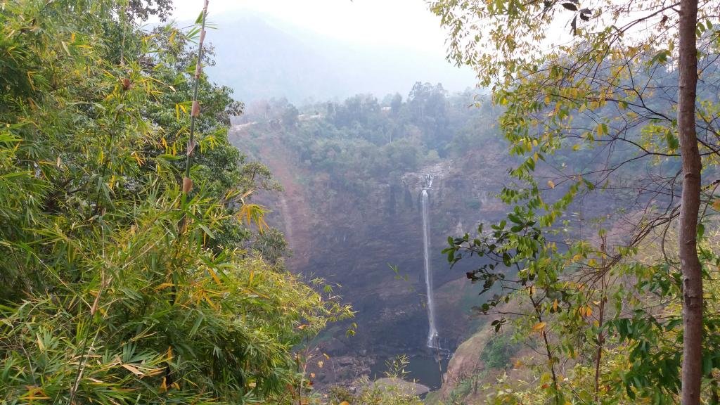
This is Tad Kamamtok, another of the Bolaven Plateau waterfalls

edit. not only didn't it link... it didn't work (does on other sites)

Oh well... try this. Click to watch

edit. Fuck that. Don't watch it then. Sorry.... but it works on at least two other sites


Well mate, I have looked into it but it is more complex than just changing the URL a bit as the moderator suggested. Apparently vBulletin is a bit of a PITA with regard to Smugmug unless vBulletin would be set to allow HTML code and that is something which is not recommended.

So it is either uploading it to YouTube or show the URL of the video directly in the post or use a shortened URL like this one Tad Katamtok on the Bolaven Plateau
 
It was low water, but still nice at Tad Hang and Tad Lo

 
Lima Site 85

 
A couple of stills from over Lima Site 85. On March 10-11 1968, this was the site of the largest loss of life of US Air Force ground personnel during the entire Vietnam / SE Asian war. 13 US and 42 Hmong and Thai and according to the Vietnamese, 1 of their troops died here. This is a 3 shot panorama over the site where the 105mm howitzer was. The helicopter landing site is off to the left.

ls85drone1.jpg


Lima%20Site%2085%20overall.jpg


and, for reference

LS85.jpg
 
This one is the triangle. Thailand, Myanmar and Laos. Just a quick whizz around this morning, before coffee at Charin. I had to de-haze it a bit, but left most of it in. Pretty crook, eh?

 
I've sorted out a little bit of that footage over the former US Air Force bombing guidance site at Phou Pha Thi, in NE Laos. I'd uploaded it yesterday without posting it... didn't like it... went back today and hacked it down in size and rendered it a bit higher. The dry season is "challenging". Auke's made the point "most people wouldn't have a clue what this is" when I mention this site... and he's right, as usual, so, some background.

The US Air Force's TACAN site (and other bits of gear) was bombing guidance equipment installed on a very isolated mountain in NE Laos and was a crucial component in the air war against North Vietnam. It shouldn't have been there, of course, given the Geneva Accord of 1962.... but it was, as were the North Vietnamese Army (NVA), who also weren't supposed to be there. It was located only 25 miles from the Pathet Lao (communist) HQ, about the same distance from the North Vietnamese border... and crucially, was just 165 miles from Hanoi. The closer to the target for this guidance system, the better.

Overall, this site guided 25% of bombing missions over North Vietnam... allowing the dropping of bombs in all weather, by remote control... and in the last couple of months before the site fell on March 11, 1968, it was guiding over 50% of missions. When if fell, it cost the USA 55 dead - 13 American and 42 Thai / Hmong. It was the US Air Force's largest loss of ground troops during the Vietnam (and wider Indochina) War. 12 of the Americans were MIA. In a string of MIA recovery operations since 1994, 3 have been retrieved, including the base commander's body. It was lost due to appalling command decisions. The Major running the site (from Thailand) went over a General's head to try and save the operators... and managed to overturn the stupidity of the Ambassador and General... but the rescue mission arrived a day too late.

Some of my drone footage of Phou Pha Thi has already gone through to the US MIA HQ back in the USA and I'm told is to be used in a current round of survivor interviews. I wish I'd been able to get more... but the 500 metre ceiling from takeoff point nobbled me there. I was also flying over a mile away... and didn't have the best flying conditions.

The second scene... with the map and the Google Earth image. That map was the NVA's attack map. They had the defences well mapped and they attacked up the cliff face.

At about the 1:25 mark, it seems I got lucky. I was pretty close to what seems to be an army base.... and someone came out. Glad he didn't have a shottie in his hands.

Incidentally, the last scene in that video also needs some explanation. It's a CIA-commissioned painting of an action that occurred before the site was lost. The CIA's intelligence on NVA and Pathet Lao knowledge of the site was excellent. The NVA constructed a road to bring equipment in to attack the site... and the USAF air raids in defence of the site peaked at 45 missions one day. The Ambassador (Sullivan) who meddled in ops prevented decent defences... but that's another story.

On January 12, 1968, four antique Soviet planes, An-2 biplanes (I've posted photos of one from Dubai at one stage)... attacked the site. Four came in, two peeled off and launched the only ever North Vietnamese Air Force attack on ground troops of the war (or so I'm told) - using 57mm wing-mounted rockets and dropping 120mm mortar bombs through a hole in the floor. A CIA chopper was inbound on a supply mission... an un-armed civilian version of the Huey. The pilot saw the bi-planes (and the base had radioed a message along the lines of "we're being attacked by f......g WW1 planes"). Ground fire shot one down, the faster chopper overhauled another and a crew member shot it down with small arms fire. The remaining two scarpered.

I should add... posting the earlier version of this video to a FB group saw it deleted and me banned, as apparently the moderator has a significant insecurity complex. What is it with all the girlie expat men in this country? By girlie, I don't mean sexuality.... I mean behaviour. Aren't we trying to share and encourage? What's the go?


We stopped on the road from Luang Prabang to Muang Hiam - formerly known as Vieng Thong (via Pak Xeng and Route 1C) and met a nasty little critter making a meal of a rat. Rather than be worrying what was curling around our feet while we looked up at the drone, we moved on a bit and flew... Here's a bit of a panorama

0s4l-3532x971.jpg


and the whole shebang... 360 degrees, although I much prefer the single side at a time view

0s4m-4460x971.jpg


Our friend the snake at the earlier stop.... making his exit from the scene into a hidey hole

0s2x-X3.jpg


... and the present that he left behind for us

0s2r-X3.jpg


Luckily for a local couple.... they'd not long walked past this bloke... and they sat down to watch us fly. We gave them a lift... and they ended up with 95% of a large bag of fried treats that I'd bought in the Nam Khan resettlement village the day before. I offered a few.... woof... half the bag gone. When we let them out, I offered the woman some... she grabbed the bag, rather than taking some. Oh well, they needed them more than me.

0s2t-X3.jpg
 
One of my favourite dirtbike roads, that one.... but we were in a hurry, so left the little 200 in the back of the truck. I'd not have enjoyed this road on that bike. I did this road in May 2014 on the 570 KTM... and it was a delight. It follows the ridgeline, through many villages, all of which have water pumped up to a single point in them. On the 570, you could slide through the corners and blast the straights. The 200 would have been thumping away on the bumps... no sliding or blasting, as it hasn't got enough guts to pull the skin off a rice custard. The difference between a good ride and a chore.

Another pickup. Two girls, out gathering the grass that Asian brooms are made from.

0s2s-X3.jpg


0s2u-X3.jpg


Their loads were damn heavy... they had to help me load it into the back of the truck. They were happy kids to have scored the lift

0s2v-X3.jpg


The next day, we flew over Lima Site 36. Auke's got some material on it, and some more photos... but here's a taster


Some Pico-Hydro power generation in a town up on Route 1c. I'm told these things kill the odd person here and there.... people go in to fix a problem... grab the power cable and it's all over red rover.

I've seen them all over Asia - Indonesia, Laos and so on. I was using the power from one when I was in Nu Pho refugee camp a few years back. Damn unreliable things... the voltage surged and spiked like crazy.

 
The mountain range near Lak Xao. 5 stills that I stitched together. Shot from 500 metres up. Posted them on a Laos FB site earlier tonight and got a request from someone at the Ministry of Information, Culture and Tourism... could they please use it in their promo material? Sure. Let's let people know what Laos is like....

LakXaopana-4462x971.jpg
 
A farewell to the Luang Prabang beaches. These only appear during the dry season and are quite the place for an evening beer. They are going to be under water all year round now, with the Xayaburi dam raising the river level as far back as here.

... and yes, there was a lot of smoke haze in the air

<br>
 
Here's the bridge across the Mekong near Pak Lay. Announced 2010, due for completion late 2013. Hmm. Not a very busy site... no security, nothing....

There's not a lot of water in the Khong. We'd just crossed over on the ferry.... on a run from Vientiane to Chiang Mai. Shot this on Tuesday 23 February 2016

 
Not from the drone... but, same day, same river. This is the dry season Mekong, from the road, looking to Thailand - between Vientiane and Pak Lay... before heading up into the hills.


mekong-2877x979.jpg


I should mention... a couple of posts back, I posted the Luang Prabang beaches... and there's a tourist boat in the video. I've been contacted by one of the six people on the boat. He remembered seeing the drone... Small world eh? He's in the white shirt, up front

lpbboat1-X3.jpg


lpbboat2-1958x979.jpg
 
Well, the things you discover....

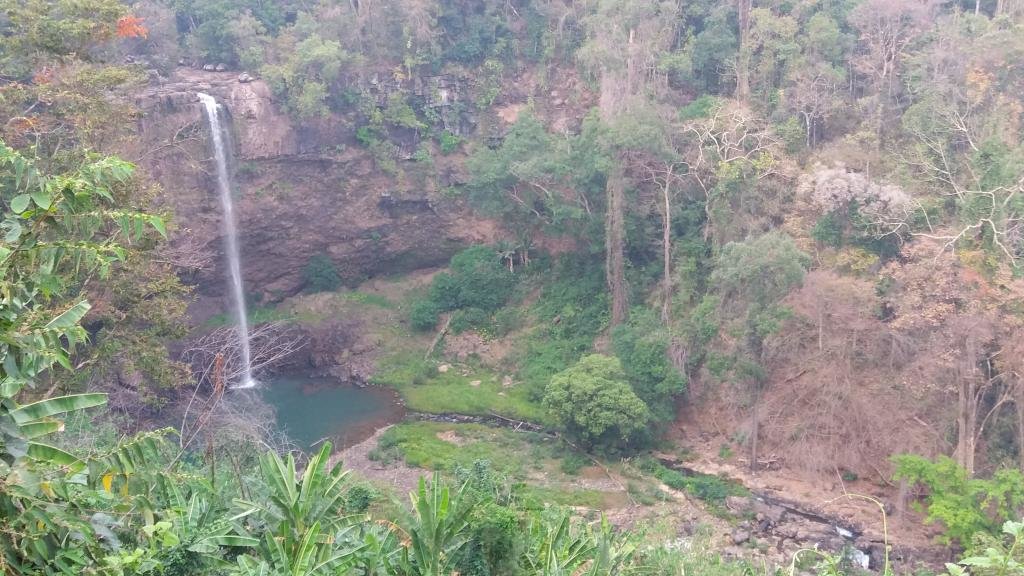
I haven't uploaded the video I shot of Tad Katamtok falls in the Bolaven Plateau. It's on Facebook and it turns out, shared 40 times and viewed near 3,000 times. I'd been a bit puzzled when we called in there, because I thought it was the falls I'd seen in 2012. I pulled out the GPS and it seems the falls I saw in 2012 are the Houay Mackchan Falls, about 1.2 kilometres away, on a different branch of the same river - and I'd approached them with the road to the left. The falls this year have a road on that side too, but we were over the other side. I'd put it all down to the fact that the road past is tarred now... but they are still on different sides of the road. So.. I'm not totally senile yet.

Here's the 2012 photo... or one of them

late5-X3.jpg


That was mid October, lots of water thundering down. Here's the difference to March this year, the other falls are relatively dry

Katamtok-X3.jpg


I'll add some more to the FB video (music and some stills before uploading it to youtube).

I'm not certain.... but I think that the second photo might be the same falls as these... from back in the day

Laosflight.jpg
 
Here's the video of the Tad Katamtok and Houay Mackchan falls


When I went through on the bike in 2012, I didn't spot the turnoff for the Tad Katamtok falls. The road is very different now, having been sealed. Back then it was 'orrible thick mud. I was getting a horrible graunching noise from my front sprocket area... I think from some stones picked up in the mud - or a tooth broken off the sprocket (I got to Siem Reap on that sprocket... but it wasn't going any further). There's a small village a few km from the falls - maybe 4 or 5 km, and I pulled off the road into it. I don't think they get many visitors. Never seen so many ladies letting it all hang out

late2-X3.jpg


late3-X3.jpg


late1-X3.jpg


The locals gave me some old sump oil for the chain... you can see it all over the ground in the shot above. That worked. No more graunching.

late4-X3.jpg
 
Here's some more from earlier this year, with a bit of 2012 thrown in. The contrast between the wet season in 2012 and the dry in February this year is stark. The stills are 2012, drone 2016

 
A couple of stills from February. Pretty sure this was on Highway 8 at Tha Bak. A bombie boat next to a traditional planked boat. Engine for the bombie boat is above it on the bank. Even has the tailfins of the drop tank still there by the look of it

bombieboatandtradit-1904x1071.jpg


That pair are centre of image below... with us up on the bridge

bombieboats-X3.jpg
 
What a difference a year and a hydropower project makes. Last year when the Big Fellah and myself went there - the Xe Katamtok waterfall along Rd. 16 - early March 2016:

Katamtok-X3.jpg


Today, a year later, also early March, when I was passing by - almost no flow left - just a piddly stream - not sure why but there has been quite a bit of rain so there should be enough water. However, at the same time a new hydro-power project (visible on the ridge line on the top left upper part of the picture) has started using part of the same river just upstream of the waterfall which may explain why there is so little water flowing through the falls:

20170308_160735.jpg
 
Auke, not a drone shot but what I filmed last September at the site.

See
https://youtu.be/56q__QjBfmM which I filmed just hours after torrential rains (on my way up to Attapeu). 48 hours later water sort of trickled down the very same cliff.

Let's see what the next rainy season will bring; doubtless to say though that the hydropower plant to the left of the picture is to blame for the devastating amendment of the Katam river - regretfully :mad:
 
Well, the things you discover....

I haven't uploaded the video I shot of Tad Katamtok falls in the Bolaven Plateau. It's on Facebook and it turns out, shared 40 times and viewed near 3,000 times. I'd been a bit puzzled when we called in there, because I thought it was the falls I'd seen in 2012. I pulled out the GPS and it seems the falls I saw in 2012 are the Houay Mackchan Falls, about 1.2 kilometres away, on a different branch of the same river - and I'd approached them with the road to the left. The falls this year have a road on that side too, but we were over the other side. I'd put it all down to the fact that the road past is tarred now... but they are still on different sides of the road. So.. I'm not totally senile yet.

Here's the 2012 photo... or one of them

late5-X3.jpg


That was mid October, lots of water thundering down.

Fast forward to March 2017 and the Houay Makchan falls are also down to a trickle

20170308_162831.jpg
 
A couple of stills from over Lima Site 85.

ls85drone1.jpg


and, for reference

LS85.jpg


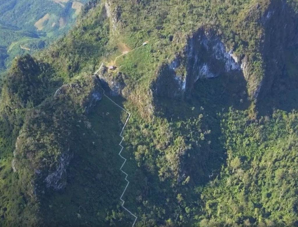
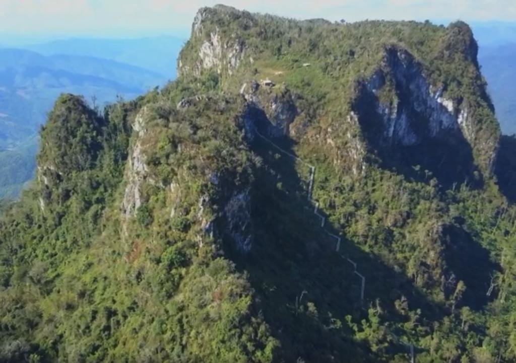
It has taken a long time but Phou Pha Thi Mountain, also known as Lima Site or LS 85, will be opened up for tourism. The official opening will be on 13 March 2018 which is 50 year and 2 days after the radar site also known as the Tacan/TSQ 81 site (No. 1 on the second picture above) was overrun in the early morning of March 11, 1968 by Vietnamese sappers who managed to climb up the mountain using the almost vertical mountain side. See also Battle of Lima Site 85


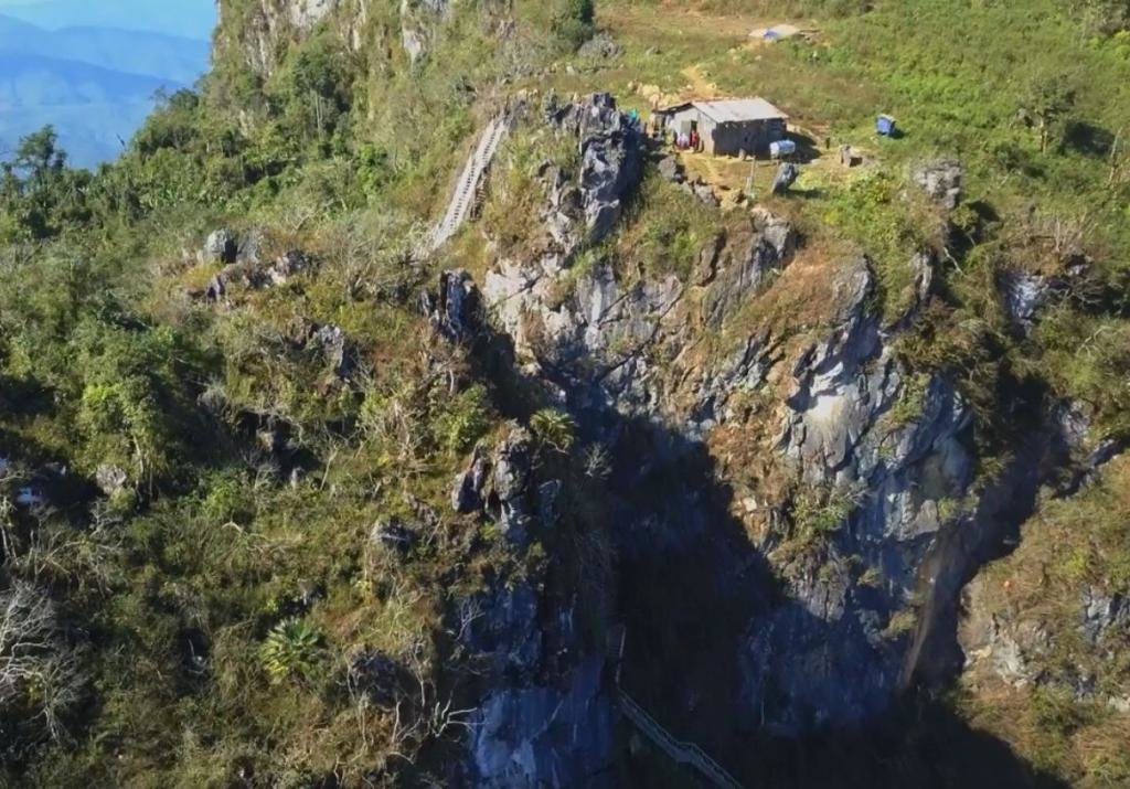
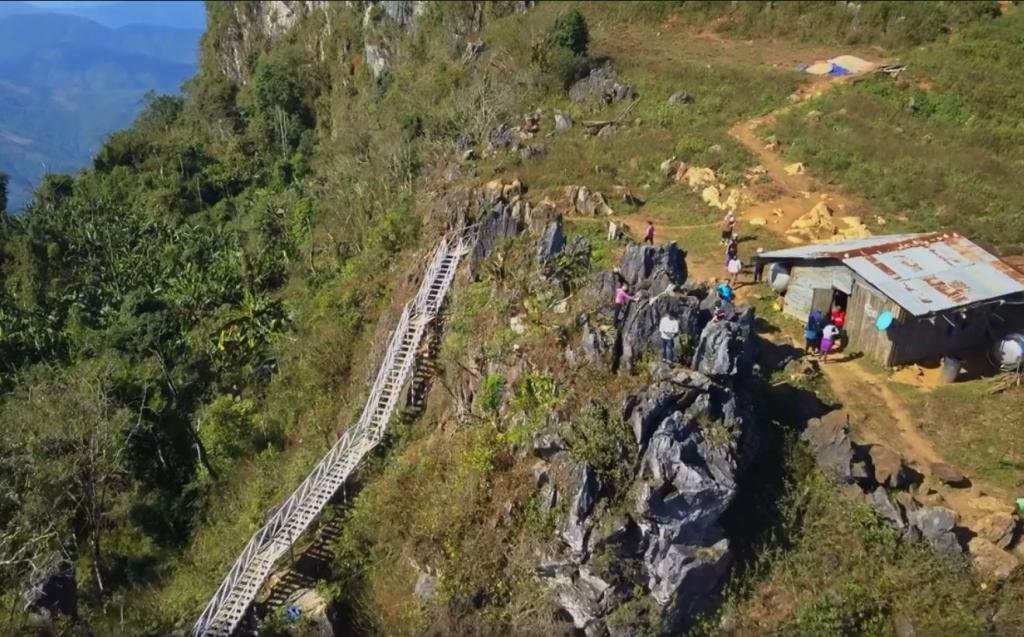
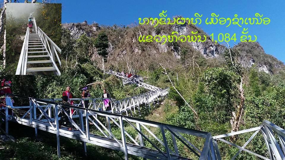
The Ladder leading to the top (No. 4 on the second picture above) has been replaced by a metal ladder system running all the way from the army post which was reachable by car and motorbike up to the army post shown on the first picture on the cliff shown on the next four pictures below.

Capture4.jpg

Capture6.jpg

Capture5.jpg

After climbing the ladder, it is still a steep uphill slog to the place where the Tacan/TSQ 81 site was located at the top of the mountain.
Capture7.jpg

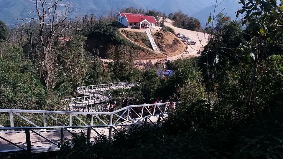
The army post which could be reached by motorbike and car has been replaced by a new building which probably presumably will house an army post as well as an information center and have a parking area while the access road has been upgraded and widened.

LS 85 1.jpg

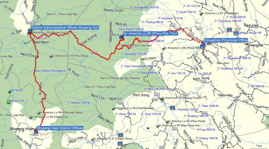
The location of LS 85

Capture8.jpg

A high res video (Copyright Ivieng Phonevilay) of the site can be found here:


By the way, even-though local people have been on the top of the mountain, access is still restricted and a group of 4 Americans were told about 2-3 weeks ago by army personnel stationed in Ban Houaymo on Rd. 3203 (Xam Nuea to Mueang Xon) that they could not go to LS 85
 
It has taken a long time but Phou Pha Thi Mountain, also known as Lima Site or LS 85, will be opened up for tourism. The official opening will be on 13 March 2018 which is 50 year and 2 days after the radar site also known as the Tacan/TSQ 81 site (No. 1 on the second picture above) was overrun in the early morning of March 11, 1968 by Vietnamese sappers who managed to climb up the mountain using the almost vertical mountain side. See also Battle of Lima Site 85


The Ladder leading to the top (No. 4 on the second picture above) has been replaced by a metal ladder system running all the way from the army post which was reachable by car and motorbike up to the army post shown on the first picture on the cliff shown on the next four pictures below.

View attachment 57989

View attachment 57987

View attachment 57988

After climbing the ladder, it is still a steep uphill slog to the place where the Tacan/TSQ 81 site was located at the top of the mountain.
View attachment 57993

The army post which could be reached by motorbike and car has been replaced by a new building which probably presumably will house an army post as well as an information center and have a parking area while the access road has been upgraded and widened.

View attachment 57990

The location of LS 85

View attachment 57992

A high res video (Copyright Ivieng Phonevilay) of the site can be found here:


By the way, even-though local people have been on the top of the mountain, access is still restricted and a group of 4 Americans were told about 2-3 weeks ago by army personnel stationed in Ban Houaymo on Rd. 3203 (Xam Nuea to Mueang Xon) that they could not go to LS 85


Not sure if they have counted the number of steps in the new staircase going up Phu Pha Ti but the Tourist Office indicate that there are 1084 steps. No confirmation yet about the opening (rumoured to be on 13 March 2018)

Only 1084 steps.jpg
 
Thread starter Similar threads Forum Replies Date
KTMphil Laos Ride Reports 6
Back
Top Bottom