Captain_Slash
Community Manager
- Joined
- Jun 28, 2011
- Bikes
- BMW 310GS Honda Wave 125 Honda MSX 125
1 Jan 2011
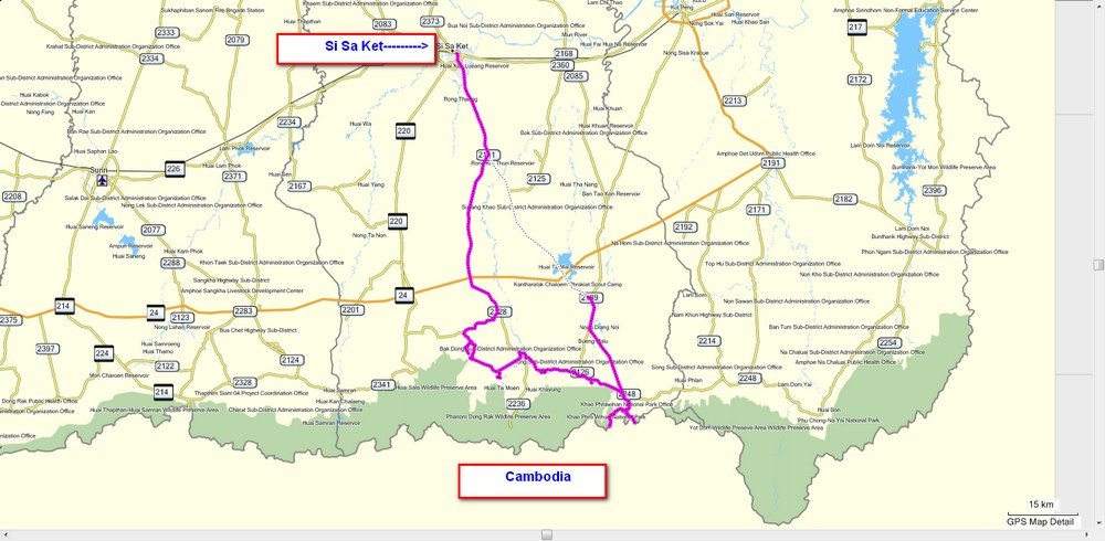
The route 221, 2335, 2341, 2128, 2111
Total distance 266 km

I took the 221 to ride to Khao Phra Viharn, there were numerous Army checkpoints before reaching the entrance where I had to leave my personal information.
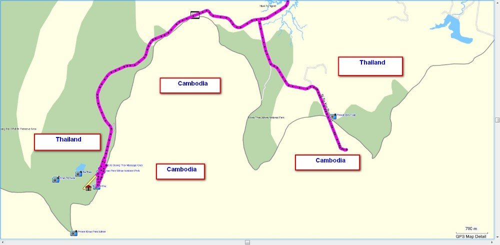
I assumed it was then okay to ride to Khao Phra Viharn and followed a local through on his bike then I took a left to ride to Prasat Don Tuan where I have been to before but today I noticed my gps was showing me as having crossed over into Cambodia before reaching it.
I rode past it to the Thai Army camp where the road finishes at N14.24.424 E104.44.763 which shows as even further inside Cambodia

200 metres back at N14.24.460 E104.44.670 is Prasat Don Tuan


It doesnt look any different since last visit about three years ago


I ride back to the 221 only to be told that motorbikes are not allowed up to Khao Phra Viharn and that I will have to park up and take a ride up in a car, not the ideal scenario but its better than not going at all, I will take the gps in my rucksack to complete the track of the 221

First the forms have to be filled in then its a 20 Baht ticket for transport

I think the 20 Baht for the ticket was a scam as a family in a truck were asked if I could ride up with them so these were my travelling companions on the way up

At the top and time to say goodbye, I walk to the gates where traffic has to stop and I assume this is the end of the road on the Thai side as I have never been allowed to ride any further at N14.24.123 E104.41.143

Khao Phra Viharn itself is closed but the cliffs are there to climb and sightsee

Razor wire everywhere around here now


Hundreds of Thai tourists up here today, I only saw a couple of Westerners up here though

Looking down into Cambodia

Perhaps they are making a road to reach it from their side

Khao Phra Viharn

A close up

Time to walk around with the other tourists

These three youngsters and their Mum were on holiday from Bangkok


I just had to get in the swing of it and be a tourist today

Time to go back, I show my blue transport ticket to an official and another family on the way down were asked to drop me off

Back under my own steam and along the 2335 a freshly planted tapioca field and some are already sprouting

At N14.29.429 E104.38.638 I take a left onto a concrete road that runs for 0.6 km to N14.29.125 E104.38.590 where it becomes a dirt track

I ride another 0.3 km to N14.29.014 E104.38.663 to the Ban Nong Udom Reservoir

Further along the 2335 at N14.30.526 E104.32.219 I take a left onto a road that runs for 0.6 km to N14.30.253 E104.32.090 then it turns to dirt, I turn round and ride back for 100 metres to N14.30.287 E104.32.101 and take a left.
This road goes for 1 km and turns to dirt at N14.30.213. E104.31.552, my gps shows this carrying on as a dirt track and meeting the 4054 which goes to the Wang Yai Waterfall, its no doubt one of the dirt tracks I saw along the 4054 the other day and I will explore it in the future

Along the 2341 at N14.30.425 E104.25.580 I take a left to explore an asphalt side road that goes through a rubber plantation

A nice new house along here

And some rubber waiting by the roadside, just a small village down this road and its offshoots

Along the 2341 at N14.31.787 E104.21.856 I take a left to ride to the Huay Chan Waterfall which is at N14.31.900 E104.21.506

I have noticed a large reservoir on my gps and find the turnoff at N14.33.814 E104.21.637

The Huai Ta Chu Reservoir 3.6 km from the 2341 to its overflow at N14.32.465 E104.21.272 and another one completely full, there must have been a good rainfall here this year as virtually all the reservoirs are full to the brim

Back in Si Saket and a buffet at N15.06.863 E104.19.461 for 119 Baht

With ice cream and sticky rice.
Get the gdb file here http://www.captainslash.com/si-saket-kh ... er-riding/
The route 221, 2335, 2341, 2128, 2111
Total distance 266 km

I took the 221 to ride to Khao Phra Viharn, there were numerous Army checkpoints before reaching the entrance where I had to leave my personal information.
I assumed it was then okay to ride to Khao Phra Viharn and followed a local through on his bike then I took a left to ride to Prasat Don Tuan where I have been to before but today I noticed my gps was showing me as having crossed over into Cambodia before reaching it.
I rode past it to the Thai Army camp where the road finishes at N14.24.424 E104.44.763 which shows as even further inside Cambodia

200 metres back at N14.24.460 E104.44.670 is Prasat Don Tuan


It doesnt look any different since last visit about three years ago


I ride back to the 221 only to be told that motorbikes are not allowed up to Khao Phra Viharn and that I will have to park up and take a ride up in a car, not the ideal scenario but its better than not going at all, I will take the gps in my rucksack to complete the track of the 221

First the forms have to be filled in then its a 20 Baht ticket for transport

I think the 20 Baht for the ticket was a scam as a family in a truck were asked if I could ride up with them so these were my travelling companions on the way up

At the top and time to say goodbye, I walk to the gates where traffic has to stop and I assume this is the end of the road on the Thai side as I have never been allowed to ride any further at N14.24.123 E104.41.143

Khao Phra Viharn itself is closed but the cliffs are there to climb and sightsee

Razor wire everywhere around here now


Hundreds of Thai tourists up here today, I only saw a couple of Westerners up here though

Looking down into Cambodia

Perhaps they are making a road to reach it from their side

Khao Phra Viharn

A close up

Time to walk around with the other tourists

These three youngsters and their Mum were on holiday from Bangkok


I just had to get in the swing of it and be a tourist today

Time to go back, I show my blue transport ticket to an official and another family on the way down were asked to drop me off

Back under my own steam and along the 2335 a freshly planted tapioca field and some are already sprouting

At N14.29.429 E104.38.638 I take a left onto a concrete road that runs for 0.6 km to N14.29.125 E104.38.590 where it becomes a dirt track

I ride another 0.3 km to N14.29.014 E104.38.663 to the Ban Nong Udom Reservoir

Further along the 2335 at N14.30.526 E104.32.219 I take a left onto a road that runs for 0.6 km to N14.30.253 E104.32.090 then it turns to dirt, I turn round and ride back for 100 metres to N14.30.287 E104.32.101 and take a left.
This road goes for 1 km and turns to dirt at N14.30.213. E104.31.552, my gps shows this carrying on as a dirt track and meeting the 4054 which goes to the Wang Yai Waterfall, its no doubt one of the dirt tracks I saw along the 4054 the other day and I will explore it in the future

Along the 2341 at N14.30.425 E104.25.580 I take a left to explore an asphalt side road that goes through a rubber plantation

A nice new house along here

And some rubber waiting by the roadside, just a small village down this road and its offshoots

Along the 2341 at N14.31.787 E104.21.856 I take a left to ride to the Huay Chan Waterfall which is at N14.31.900 E104.21.506

I have noticed a large reservoir on my gps and find the turnoff at N14.33.814 E104.21.637

The Huai Ta Chu Reservoir 3.6 km from the 2341 to its overflow at N14.32.465 E104.21.272 and another one completely full, there must have been a good rainfall here this year as virtually all the reservoirs are full to the brim

Back in Si Saket and a buffet at N15.06.863 E104.19.461 for 119 Baht

With ice cream and sticky rice.
Get the gdb file here http://www.captainslash.com/si-saket-kh ... er-riding/


