Johnsy
Member
Most of you already know this but I haven’t seen a post explaining how to set up Google Earth to give you WGS84 Easting and Northing coordinates that are the same as what is displayed on a GPS.
The reason I’m writing this is because I’ve seen some posts giving coordinates for a location but the coordinates were from Google Earth or using a different datum or format. Datum and formats work in different ways giving different coordinates for the same location. So typing default Google Earth coordinates into your GPS and pressing “go to” simply doesn’t work.
Google Earth expresses the Earth as a 3 dimensional spherical image and locations in Latitude and Longitude using a default format of decimal degrees, DDD.DDDDD° - e.g. lat 13.852514° lon 100.496630°
GPS’s express the Earth as a 2 dimensional “paper map style” image and locations in WGS84 Eastings and Northings using a default format of degrees decimal minutes, DDD° MM.MMM' – ie lat 13° 51.151'N lon 100° 29.798'E
Both of these coordinates - lat 13.852514° lon 100.496630° and lat 13° 51.151'N lon 100° 29.798'E are of the same place on the Earths surface but use different formats to express this. The problem with having different formats to reference a specific location on the Earth’s surface is that unless I am using the same format as you your coordinates are not going to help me, may give me the wrong location altogether or will simply be unusable.
As far as I know all GPS’s now use the WGS84 map datum as a default setting and the position format of hddd°mm.mmm as a default setting (hddd°mm.mmm - h=hemisphere, ddd=degrees of latitude or longitude, mm.mmm=minutes of latitude or longitude expressed to 1/1,000th of a minute). This enables all GPS’s to operate in the same way using the same datum, format and coordinates.
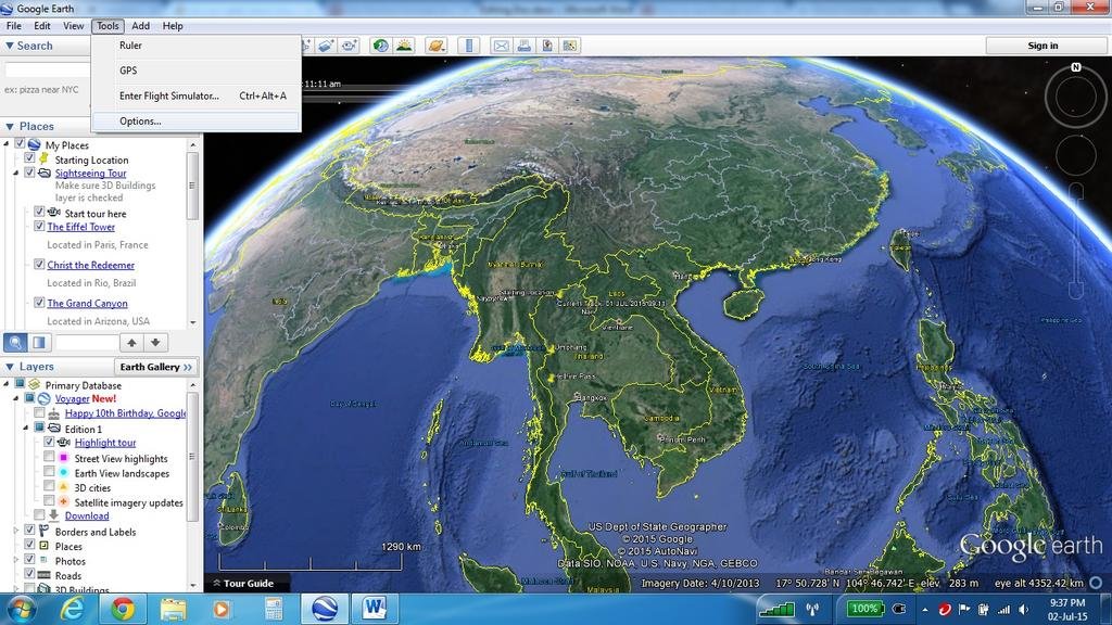
It’s easy to set up Google Earth to display the same coordinates as your GPS that uses degrees decimal minutes (hddd°mm.mmm). Open Google Earth, click on “Tools” then click on “Options” on the drop down menu.

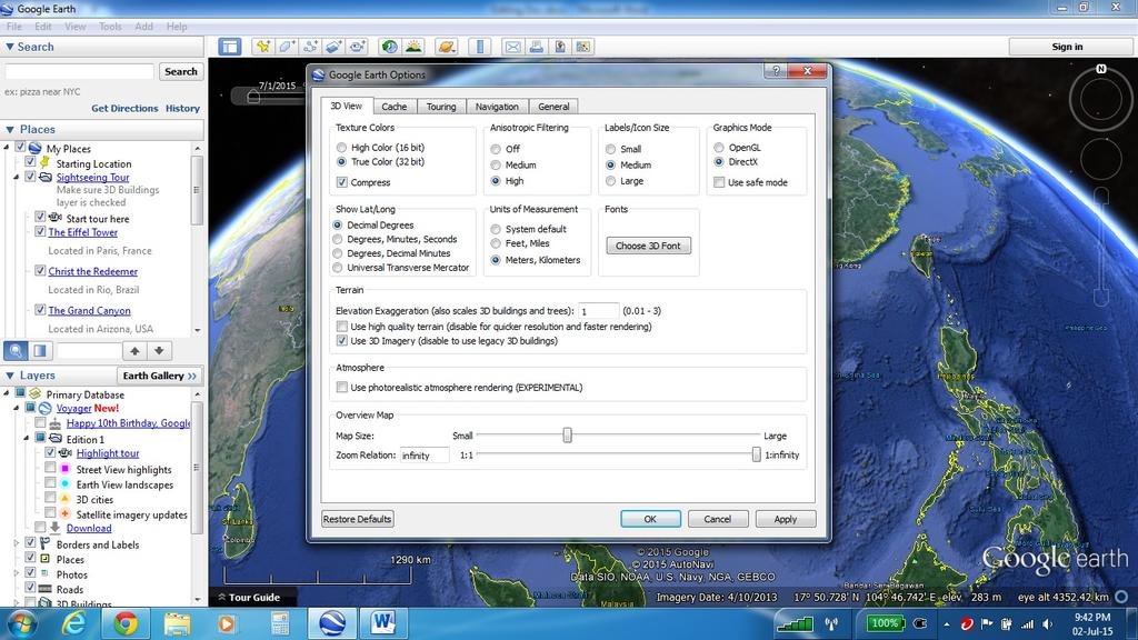
In the dialogue box under “3D View” there is a setting for “Show Lat/Long”. By default Google Earth is set to “Decimal Degrees” we want to change this to degrees decimal minutes.

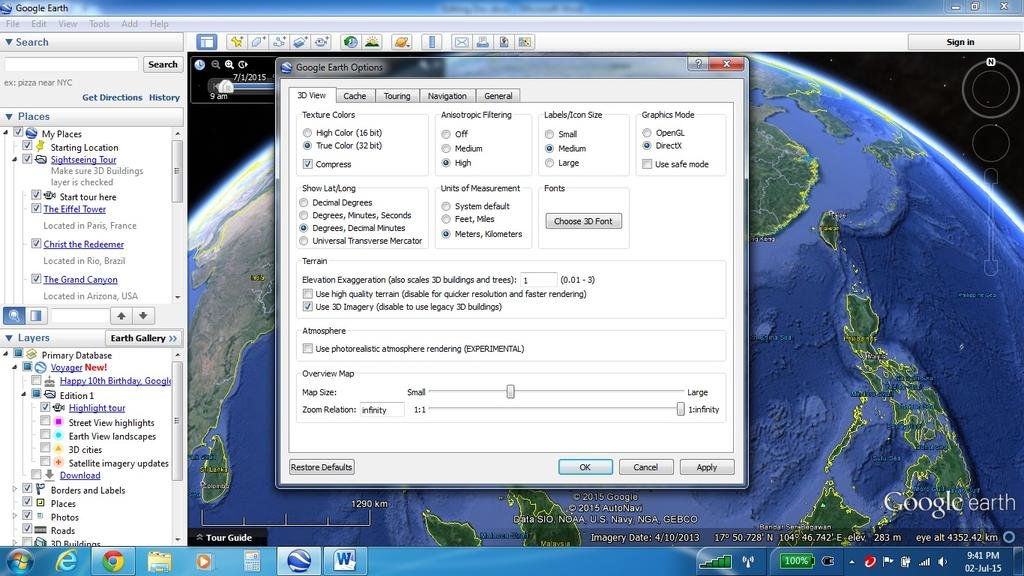
To do this just click on the “Degrees, decimal minutes” and now click the “Apply” button and the “ok” button. Google Earth will now display the same coordinates that your GPS uses and that you can use with your GPS.

Here’s a few links to some detailed information about this issue and explanations of Map Datum and Position Formats.
http://www.treasurenet.com/forums/g...use-gps-if-you-want-find-shipwrecks-read.html
https://www.maptools.com/tutorials/lat_lon/formats
http://bhgcinfo.wikidot.com/tutorials:gps-position-formats-and-map-datums
http://stpxml.sourceforge.net/skygod/Navigation/Coords.html
https://en.wikipedia.org/wiki/World_Geodetic_System#Longitudes_on_WGS_84
The reason I’m writing this is because I’ve seen some posts giving coordinates for a location but the coordinates were from Google Earth or using a different datum or format. Datum and formats work in different ways giving different coordinates for the same location. So typing default Google Earth coordinates into your GPS and pressing “go to” simply doesn’t work.
Google Earth expresses the Earth as a 3 dimensional spherical image and locations in Latitude and Longitude using a default format of decimal degrees, DDD.DDDDD° - e.g. lat 13.852514° lon 100.496630°
GPS’s express the Earth as a 2 dimensional “paper map style” image and locations in WGS84 Eastings and Northings using a default format of degrees decimal minutes, DDD° MM.MMM' – ie lat 13° 51.151'N lon 100° 29.798'E
Both of these coordinates - lat 13.852514° lon 100.496630° and lat 13° 51.151'N lon 100° 29.798'E are of the same place on the Earths surface but use different formats to express this. The problem with having different formats to reference a specific location on the Earth’s surface is that unless I am using the same format as you your coordinates are not going to help me, may give me the wrong location altogether or will simply be unusable.
As far as I know all GPS’s now use the WGS84 map datum as a default setting and the position format of hddd°mm.mmm as a default setting (hddd°mm.mmm - h=hemisphere, ddd=degrees of latitude or longitude, mm.mmm=minutes of latitude or longitude expressed to 1/1,000th of a minute). This enables all GPS’s to operate in the same way using the same datum, format and coordinates.
It’s easy to set up Google Earth to display the same coordinates as your GPS that uses degrees decimal minutes (hddd°mm.mmm). Open Google Earth, click on “Tools” then click on “Options” on the drop down menu.

In the dialogue box under “3D View” there is a setting for “Show Lat/Long”. By default Google Earth is set to “Decimal Degrees” we want to change this to degrees decimal minutes.

To do this just click on the “Degrees, decimal minutes” and now click the “Apply” button and the “ok” button. Google Earth will now display the same coordinates that your GPS uses and that you can use with your GPS.

Here’s a few links to some detailed information about this issue and explanations of Map Datum and Position Formats.
http://www.treasurenet.com/forums/g...use-gps-if-you-want-find-shipwrecks-read.html
https://www.maptools.com/tutorials/lat_lon/formats
http://bhgcinfo.wikidot.com/tutorials:gps-position-formats-and-map-datums
http://stpxml.sourceforge.net/skygod/Navigation/Coords.html
https://en.wikipedia.org/wiki/World_Geodetic_System#Longitudes_on_WGS_84

