Road book

tysurrfer

Junior Member
Joined
May 14, 2012
Bikes
KTM 690R Enduro, Ninja 1000, CRF250l, BMW sidecar
Does anyone in Thailand have a road book map of an area in thailand that I can buy and use in order to learn how to ride with one? or and other suggestion on how to get or use a Road book?

Thanks,
 
Does anyone in Thailand have a road book map of an area in thailand that I can buy and use in order to learn how to ride with one? or and other suggestion on how to get or use a Road book?

Thanks,

I am probably stupid as I have no clue what a "Road Book" is so it might help if you could explain what a road book map is.
 
I am guessing its a series of instructions like a rally one ?? The ones they put on the 2 scroll wheels ??
 
I am guessing its a series of instructions like a rally one ?? The ones they put on the 2 scroll wheels ??

Yes, I was thinking about that also but I assume that it will be difficult to find something like that in Thailand. Another thing might be something I found quite some time ago on the website of one of the car rental companies for recommended loops. Here is a bit from their "Mae Hong Son loop"

DAY 1 : CHIANG MAI - PAI (128 kms.)

The drive begins with the fast main highway as far as Mae Malai (KM.36). Unless you visit the Mae Sa Valley (recommended if renting for one day only), or go on a slower alternative route, the interesting part of the journey really begins once you leave Mae Malai on the highway to Pai.

From Mae Malai the road passes lowland villages and orchards, and you can visit the lovely rural temple of Wat Tha Kham (KM.10 left turn [south] on sealed road 1.5 kms.) and the popular Mok Fa waterfall (KM.18.Left turn [south] 1.5 kms.). After 20 kilometres the first set of switch-backs takes the route to a height of about 700 metres and to a series of upland valleys. Lisu and Hmong hill tribe villages occupy the uplands, while Karen villages are found lower down.

The higher hills, which rise to between 1200 and 1400 metres, are often hidden from the road. Dirt roads link villages all over these hills, but if you wish to stretch your legs you can take a steep uphill hike (about 20 minutes) to the Lisu village of Mae Sa from the forestry station at KM.52 (N.B. You can drive into Lisu villages easily on day 2.)

The road reaches a height of 1350 metres between KM 60-70 on the watershed between the River Pai, which drains into the Gulf of Martaban via the Salween, and the River Mae Taeng, which drains into the Gulf of Thailand via the Ping. On this high ground side trip 3 takes you to the viewpoint at Huai Nam Dang, which is famous for its view over the Mae Taeng Valley towards Chiang Dao mountain. Numerous switch backs take the road to the floor of the River Pai valley at KM.85 and the twelve kilometre run to the town of Pai.

Pai

This small wooden town (pop. circa 15,000) is mostly Shan, some of whom are Muslim. The road to the town was first built by the Japanese in the Second War in their push to Burma. Pai has long been popular with backpackers and has plenty of cheap guest houses and restaurants.

Around Pai

Visiting the hot springs, taking an elephant ride, or going on a two hour walk to the Mae Yen Falls are among the possibilities. A short drive past the hospital goes to a Haw Chinese (Kuomintang) and a Lisu village, from where a dirt road leads to Mo Paeng Falls (also reached by concrete road H1095 KM.101. 5 kms.). A longer dirt-road drive goes to the Karen village of Muang Noi (35 kms.), but for anywhere else, you should get advice and take a guide.

DAY 1: SIDE TRIPS

ST1 The Mae Sa Valley and Samoeng

(From Key Point 2. KM.17. Left [west turn] 38 kms to Samoeng. Time: Min 120 min. Allow 4 hours if taking an elephant ride.) - The upland valley of the Mae Sa is 700 metres in altitude, making it a prime location for resorts near Chiang Mai. The Regent Resort, Chiang Mai, is the best in Northern Thailand, and the Pong Yaeng Garden Village has a lovely setting. Major attractions include the orchid farms (try the Sainamphung or Mae Ram Orchid Farms), the Mae Sa Falls, the Queen Sirikit Botanical Gardens (under development) and the elephant camps (NB. Elephant rides are also available in Pai). The road passes into the Samoeng Valley at KM.23, from where there are spectacular views west. Dirt roads lead to Hmong villages in the hills of the Doi Suthep-Pui National range that surround the Mae Sa Valley. The small market town of Samoeng lies in a narrow valley with pleasing rural scenery.

ST2 Pong Duet Hot Springs

(KM.42. Right turn [north 4WD] 6 kms. 90 min) - A delightful park offers walks, small pools for bathing and a sala, where snacks and drinks are sold.

ST3 Huai Nam Dang National Park

(KM.65. Right turn [north]. Asphalt 6 kms. 60 min.) - A 1600 metre viewpoint best at sunrise in the cold season.


Note LR: I have been toying with the idea of updating these "Loop Descriptions" as they are a bit dated and make them available here on this site but I am not sure if there is an interest in this
 
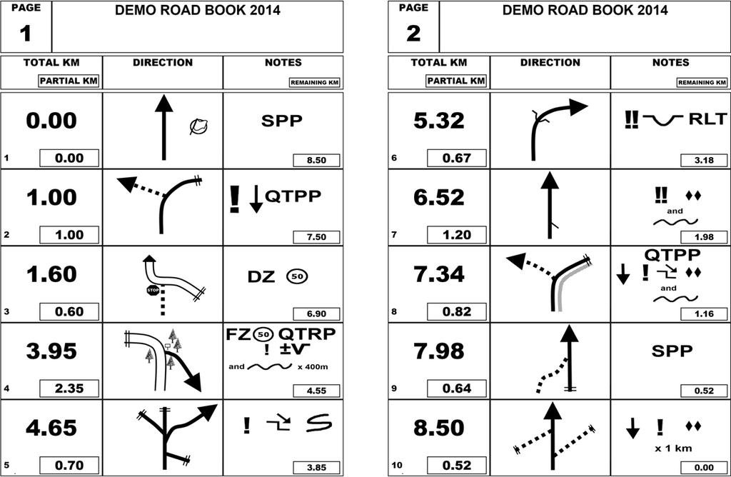
Correct, the series of instructions for rally on the 2 scrolls on the handlebars. Here is a sample of the instructions which go in the roller on the handlebars.
roadbook_sample_small.jpg
 
Surely anything like this would have to be custom made for any particular route ??
 
Thread starter Similar threads Forum Replies Date
A GPS - Help and Discussion 5
Lone Rider GPS - Help and Discussion 0
Back
Top Bottom