alexuk
Senior Member
- Joined
- Jan 30, 2011
2 klx250 from CP motors, an xr250 and my klx300
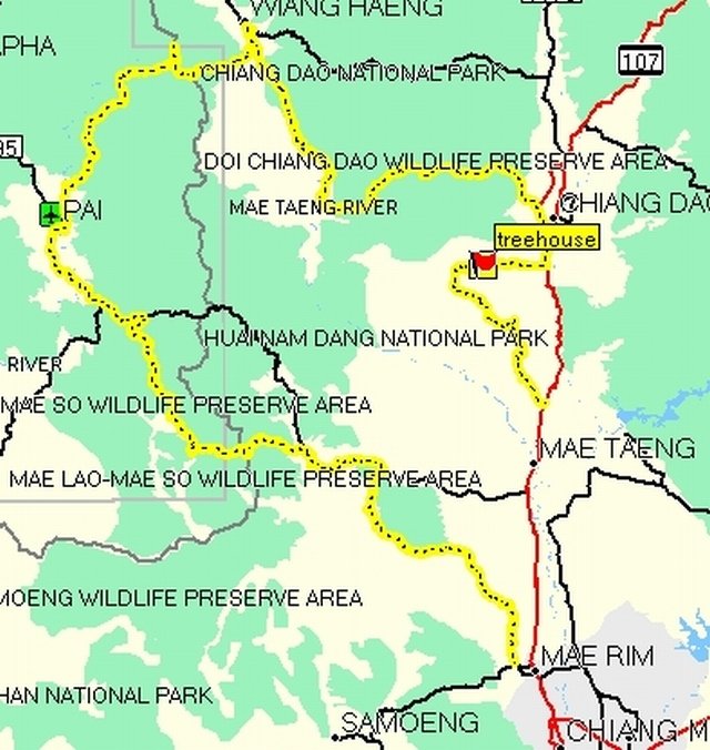
We planned an easy offroad 2 night trip since 2 of the guys hadnt done much offroad, using a GPSmap from Riders Corner, with many dirt trails on it,and the GTrider map.
The route for the 1st day was to Pai via Mok Fa Falls.
As we left about 11am we rode to mae rim, then followed a sideroad near the Xcentre onto a dirt road about 15km further, which was a nice open track up to Mok Fa.
Time was getting on and we were starving so we didnt see the falls,which are very nice, and only 5minutes walk, headed for one of the good eateries on the main road.Our 1st choice was busy so we took the next one 300m away.
Then we had 15k on the road to Pai, and got some gas in a little village just off the road(north side) and went on to the turn off at Pa Pae
This was a great trak with some stupendous views. The riding all got a bit close at times, I had a wheel in the side, and later couldnt brake fast enough as the guy in front braked hard, cos the one in front of him braked hard, so 2 of us went down in the dust. All good fun, except the helmet camera was off.
We came back to the Pai road not far from the wat chan turn, and went to some resort over the bridge which was real quiet and cold. I had to wear all my clothing all night.
Day2, We got ready,left GH had breakfast and got some gas and supplies from the 711 there, checked tyres, and one bike fixed at the bike shop opposite.
We'd decided to try to get to chiang dao as none of us had been that way, and I led the way to the trail head, same start as some other good routes, We stopped at some stream crossing to get some video, and carried on checking the gps every so often.
Past Muang Noi, We came to a turning I remembered,not on the map, where the road turns to Bor Nam Yai. After a while it turns to easy singletrack, through remote forests and mountains, until it comes out in a village near wiang heng.
At the junction there, we met 2 guys on big bikes, a gs1200 and the latest Ducati multistrada, with 150bhp, electronic suspension,traction control,abs,etc.He'd turned it all off and still was sliding down steep hills on the dual purpose tyres, which looked like road tyres to me. Anyway, they had turned north from the Pai road at the checkpoint, and made it this far ok.
[center:2s9ub4da]
[/center:2s9ub4da]
April 10 there is now a suspension bridge her, fairly narrow and wobbles in the middle
http://www.flickr.com/photos/21921110@N04/5605993620/
http://youtu.be/68E-J_9E2Ls
[VIDEO]http://youtu.be/68E-J_9E2Ls[/VIDEO]
So off to wieng hang for some food, then backtracked to get onto the trail besides the Mae Tang river through huai ya sai to muang khong, which says "motorcycle only" on the map. This is a great track, through shady forest and many stream crossings, until we came to a river. There was a choice of ways on my gps, one tricky singletrack up a mountainside, which we could have
managed with a bit of pushing, (there's a steep concrete path near the start), or through the river.it was only a short track, but we didnt know at the time.The guys wanted the river, so Robin was keen, just tried to ride through, but got a bit sideways on the slippy rocks. The others went in to help out and pushed him through. Then we looked for a better way, The river got slower and deeper a few yards up,just a few stones near the side, then sandy right across. Hip deep and 10+ metres across, we ran the engines and walked the bikes through. It took us about an hour to cross because we took our time unloading bikes and finding the best way through.The helmet camera was on, but the battery ran out.
[center:2s9ub4da]
[/center:2s9ub4da]
Then there was some confusion as the main track was blocked, we followed small tracks beside the river for 1/200 metres then the path was destroyed so we had to find another crossing.This was easy, we just rode through, there were some locals living out there wanted to help, the difficult bit was riding the bikes up a soft sand slope to join the main trail.
(The locals had just passed on a scoooter, up the mountainside)
The main track was big enough for a 4wd there, and there was a crane/bulldozer making the road.
We got into Muang Noi, and found a gas stop and filled up, when robin realised his bag wasnt on his bike. So he sped off totry to find it,it took 20 minutes fro him to return with it. An old man had found it, and put it unopened in his bag, robin noticed as he went by, got it back, and gave the old fella a big tip.
Fom Muang Noi, the road got concrete and windy, Blake was enjoying riding fast through all the corners for the next 20kms down the mountain, and I stayed behind him. Then we were at a gateway to the park, we stopped to wait for the others and put some warm clothes on, as it was cool and getting dark. By the time we did the 20km to chiang dao it was dark,and we headed
for the hotel. I say hotel, but it was some resort Robin knew a few km away.
So after riding exhausted for half an hour back into the mountains on a single lane windy road with cows and shit, we arrived, woke up the owner, had some supper and sat around a wood fire, in a big wood 3storey house built on a hillside,dead quiet, in the middle of nowhere, with a few beers.
I slept pretty good, got up early and walked down to the stream, loads of birds around,had breakfast and had a sauna, while the others slept.
As we were so far from civilization, the resort guy got us some gas from chiang dao, and we headed back into the jungle. Dirt track was good riding for a while , then we got onto a minor road, and used the gps to find our way, till we got on the Route 107 near Mae Tang, and made our own way back to Chiang Mai
Hopefully I can get some fotos soon to post here. And gpx track
We planned an easy offroad 2 night trip since 2 of the guys hadnt done much offroad, using a GPSmap from Riders Corner, with many dirt trails on it,and the GTrider map.
The route for the 1st day was to Pai via Mok Fa Falls.
As we left about 11am we rode to mae rim, then followed a sideroad near the Xcentre onto a dirt road about 15km further, which was a nice open track up to Mok Fa.
Time was getting on and we were starving so we didnt see the falls,which are very nice, and only 5minutes walk, headed for one of the good eateries on the main road.Our 1st choice was busy so we took the next one 300m away.
Then we had 15k on the road to Pai, and got some gas in a little village just off the road(north side) and went on to the turn off at Pa Pae
This was a great trak with some stupendous views. The riding all got a bit close at times, I had a wheel in the side, and later couldnt brake fast enough as the guy in front braked hard, cos the one in front of him braked hard, so 2 of us went down in the dust. All good fun, except the helmet camera was off.
We came back to the Pai road not far from the wat chan turn, and went to some resort over the bridge which was real quiet and cold. I had to wear all my clothing all night.
Day2, We got ready,left GH had breakfast and got some gas and supplies from the 711 there, checked tyres, and one bike fixed at the bike shop opposite.
We'd decided to try to get to chiang dao as none of us had been that way, and I led the way to the trail head, same start as some other good routes, We stopped at some stream crossing to get some video, and carried on checking the gps every so often.
Past Muang Noi, We came to a turning I remembered,not on the map, where the road turns to Bor Nam Yai. After a while it turns to easy singletrack, through remote forests and mountains, until it comes out in a village near wiang heng.
At the junction there, we met 2 guys on big bikes, a gs1200 and the latest Ducati multistrada, with 150bhp, electronic suspension,traction control,abs,etc.He'd turned it all off and still was sliding down steep hills on the dual purpose tyres, which looked like road tyres to me. Anyway, they had turned north from the Pai road at the checkpoint, and made it this far ok.
[center:2s9ub4da]
April 10 there is now a suspension bridge her, fairly narrow and wobbles in the middle
http://www.flickr.com/photos/21921110@N04/5605993620/
http://youtu.be/68E-J_9E2Ls
[VIDEO]http://youtu.be/68E-J_9E2Ls[/VIDEO]
So off to wieng hang for some food, then backtracked to get onto the trail besides the Mae Tang river through huai ya sai to muang khong, which says "motorcycle only" on the map. This is a great track, through shady forest and many stream crossings, until we came to a river. There was a choice of ways on my gps, one tricky singletrack up a mountainside, which we could have
managed with a bit of pushing, (there's a steep concrete path near the start), or through the river.it was only a short track, but we didnt know at the time.The guys wanted the river, so Robin was keen, just tried to ride through, but got a bit sideways on the slippy rocks. The others went in to help out and pushed him through. Then we looked for a better way, The river got slower and deeper a few yards up,just a few stones near the side, then sandy right across. Hip deep and 10+ metres across, we ran the engines and walked the bikes through. It took us about an hour to cross because we took our time unloading bikes and finding the best way through.The helmet camera was on, but the battery ran out.
[center:2s9ub4da]
Then there was some confusion as the main track was blocked, we followed small tracks beside the river for 1/200 metres then the path was destroyed so we had to find another crossing.This was easy, we just rode through, there were some locals living out there wanted to help, the difficult bit was riding the bikes up a soft sand slope to join the main trail.
(The locals had just passed on a scoooter, up the mountainside)
The main track was big enough for a 4wd there, and there was a crane/bulldozer making the road.
We got into Muang Noi, and found a gas stop and filled up, when robin realised his bag wasnt on his bike. So he sped off totry to find it,it took 20 minutes fro him to return with it. An old man had found it, and put it unopened in his bag, robin noticed as he went by, got it back, and gave the old fella a big tip.
Fom Muang Noi, the road got concrete and windy, Blake was enjoying riding fast through all the corners for the next 20kms down the mountain, and I stayed behind him. Then we were at a gateway to the park, we stopped to wait for the others and put some warm clothes on, as it was cool and getting dark. By the time we did the 20km to chiang dao it was dark,and we headed
for the hotel. I say hotel, but it was some resort Robin knew a few km away.
So after riding exhausted for half an hour back into the mountains on a single lane windy road with cows and shit, we arrived, woke up the owner, had some supper and sat around a wood fire, in a big wood 3storey house built on a hillside,dead quiet, in the middle of nowhere, with a few beers.
I slept pretty good, got up early and walked down to the stream, loads of birds around,had breakfast and had a sauna, while the others slept.
As we were so far from civilization, the resort guy got us some gas from chiang dao, and we headed back into the jungle. Dirt track was good riding for a while , then we got onto a minor road, and used the gps to find our way, till we got on the Route 107 near Mae Tang, and made our own way back to Chiang Mai
Hopefully I can get some fotos soon to post here. And gpx track