Mapping Shan State Myanmar borders areas

KTMphil

Senior member
Joined
Jan 11, 2011
Location
Chiang Mai, Thailand
Bikes
2007 KTM 990 Adventure Suzuki DRZ 400
Mapping Shan State, Myanmar borders areas


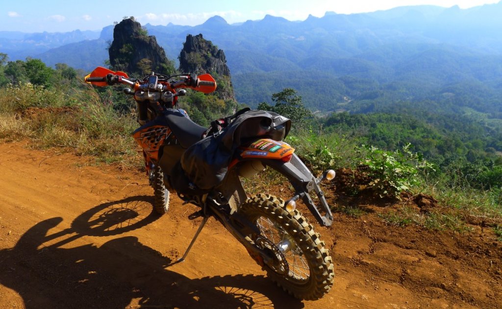
Was itching to take the KTM 300 EXC-E 2-stroke somewhere, Auke wanted some mapping data towards the Shan State, Myanmar border in north west Thailand, so it seemed a good excuse to go riding.
first photo.jpg


A good thing about being on R 1095 (road to Mae Hong Son) at 0600am is that you get to see the moisture rise

6518512743_61606c6b3f_b.jpg
 
"School bus" headed towards Pang Mapha (Soppong)

6518513019_4ff7fe1291_b.jpg


After the windy drive west, gave the Lemon Hill GH a shot in Pang Mapha, 500 bht, not bad for the money.

6518513931_452c2040ec_b.jpg


6518513771_b8c2c89688_b.jpg


6518514717_44d43cd5f3_b.jpg


Being right on the Nam Lang river, the sound of the rushing water sends you straight to sleep

6518513413_2fcedf2027_b.jpg


Inquired at the Rock Garden GH, cheapest room was 1,500bht, so not for me.


The market in Pang Mapha is directly opposite the Lemon Hill GH, handy for preparing for a few days riding in the sticks

6518514471_39a215b2cb_b.jpg


6518514069_e5e8a7f33a_b.jpg
\


6518514293_d1ae20b116_b.jpg
 
Early morning in Pang Mapha (Soppong)

6518513147_6db63d03f4_b.jpg


Then off to the Ranger checkpoint on R 4015, 3 Km north of the Nam Khong Police box (junction R 1095 & R 4015) - Notice the map in the far left of the photo on their hut, more on that later

6518516579_ab94258e2c_b.jpg


6518549051_10ab34e6eb_b.jpg


1st days mapping, I initially wanted to get to Ban Huay Sa (some call it Ban Huoy Sun). It's to the west of R 4015 on a 50/50 dirt & concrete road. Lots of steep up's and downs, but well worth the trip. As far as I know this road and village currently isn't on any maps of this region, so good to get the unique data.

6518580609_eb88defc76_b.jpg

Map Copyright ©www.RideAsia.net - Permission to copy required
 
After the visit to Ban Huay Sa, Off NNE to the Shan border at Loi Tai Leng, mapping the dirt trails on the way

6518528931_2fa7a0782c_b.jpg


It's currently difficult to get into the Shan State Army camp at loi Tai Leng, advisable to try and get a permit at the Mae Hong Son Government office


Then SE to the Shan checkpoint at the road Wah tribe. You can see the Wah tribe checkpoint on the top right of the map below

6518580609_eb88defc76_b.jpg


The checkpoint, looking north

6518524357_16ac71608f_b.jpg


6518524199_7065d37e7a_b.jpg


Had a go at getting into the Wah village, cigarettes nor cash didn't help, but the Thai military commander was kind enough to take me to his look out

6518524021_d9c315714e_b.jpg


From the look out, you can see the Shan State Army's look out post to the left & the Wah look out to the right, amazing how close they are considering only 4 years ago these tribes were still at war with each other.

6518523597_11d15235b8_b.jpg


6518523843_a72fdeb9a5_b.jpg


The road from the Thai Army checkpoint that leads to the Wah village


6518523241_d4c9ab76d7_b.jpg


6518522681_7d20f5614e_b.jpg
 
Then off south to get some more tracks and waypoint data, we've got most of the fuel shops mapped in the area now


6518528721_10f926a9b7_b.jpg


6518528503_0f7924e720_b.jpg


Looks like they were getting ready for sports day at one of the local schools near the border

6518528303_0e7e5f54f9_b.jpg


Got some decent data for Auke on the way down

6518628171_282e5a953e_b.jpg


R 1226 at the more southern end

6518521945_a541684dac_b.jpg
 
The village of Ban Pang Kham is only 5km south of the Loi Tai Leng border. Here you can get fuel, food & cold drinks. The photo below shows the dirt road north to Loi Tai Leng

6518527581_8ece5a149f_b.jpg


Beautiful views in the Ban Pang Kham area

6518524889_a46f179b5b_b.jpg


6518524565_4413193b8e_b.jpg


One of the dirt roads near Ban Pang Kham that Auke already had mapped, it continued some more


6518525481_36c105b0d8_b.jpg


6518525239_0a9653b256_b.jpg
 
9 hours of mapping i was pretty knackered - back to the ranger checkpoint to get organized for the night.

6518512369_d0986d5987_b.jpg


6518519809_a15789d39d_b.jpg


I gave them one of the RideAsia.net - "North Thailand Road & Off-Road" maps, which the proudly stuck up on the checkpoint hut

6518549431_c86815d486_b.jpg
 
1KM north of the Nam Khong police box, on R 1095 (road to MHS) TURN RIGHT onto R 4015 is the "Wilderness Lodge" 1km north. Heading north on R 4015, it's a turn on your RHS

6518516841_502a6cd322_b.jpg


6518518697_8c2cea1e17_b.jpg


The bridge is strong enough for motorbikes, stay to you RHS

6518517049_df8d29acc4_b.jpg


Peter, who runs the place charged me 100 bht to sleep inside this tent with a clean pillow case and blankets ( Colin would be proud)

6518519123_37ffdd36b3_b.jpg


It has the same feel to it as the Cave Lodge & funnily enough the story goes that John who own the Cave Lodge, built the Wilderness Lodge for his sister-in-law.
 
The Wilderness Lodge is an EXCELLENT base to use for exploring the area by dirt bike. Below Peter who runs the Wilderness Lodge

6518519015_63679bbeac_b.jpg


There are bungalows there too

6518518511_245ab13ec9_b.jpg
 
Peter making us some hot tea in the morning

6518517769_403292b6c3_b.jpg


Then off for another days mapping, this time in a NW direction, plan was to get as NW as possible

6518616547_ab88fca742_b.jpg

Map Copyright ©www.RideAsia.net - Permission to copy required


Some beautiful mountains on the way north

6518522117_0b8b8f8c66_b.jpg


6518512165_dc40447fc9_b.jpg


They are several villages on R 4015 north, most of them (probably all) have fuel available, some even have 95 octane benzine

6518542033_6c85597b98_b.jpg


6518521457_6756046e3f_b.jpg


6518542397_900fa9af69_b.jpg
 
Spectacular views half way north on R 4015

6518526465_cf7250ffab_b.jpg


Helicopter pad for the Thai Military

6518544897_50134d50df_b.jpg


Poking around off of R 4015, the views were amazing

6518544107_49b8e1b727_b.jpg


Farmers working the hillside fields

6518542703_f6be541b96_b.jpg
 
At the north end of R 4015, near the Shan border, there's a dirt loop to the east, with great views

6518545865_c3f8c2668a_b.jpg


6518544557_829ddfcff6_b.jpg


6518530765_9b1307a59b_b.jpg


Exploring off R 4015

6518530195_078907d085_b.jpg
 
This is at the very north end of R 4015, at the village of Ban Khong. A new Dam is being buily

6518546733_3a07f41453_b.jpg


6518547101_4a30d28cc8_b.jpg


6518546443_3ccb9eccc7_b.jpg


6518546193_0e7ea09cc7_b.jpg


Here at the very north end of R 4015 looking east - this might be a trail through to Myanamar, which would be just over the hill

6518545981_c0004f3ae0_b.jpg


The village of Ban Khong at the very north end of R 4015, there is fuel available here

6518543153_391b96238f_b.jpg
 
The trail through the national park at the very north end of R 4015 next to the village of Ban Khong

6518543775_b3cb17fdb7_b.jpg


6518543409_a8235b6549_b.jpg


Very nearly got stuck here

6518541479_d570be767b_b.jpg


A Shan Wat on the way down

6518541095_aa43afcc7b_b.jpg


Another Shan Wat

6518539537_9e0dfab04d_b.jpg


6518547653_31fcc7441d_b.jpg
 
Concrete wall to protect the village from the rising river in rainy season

6518539335_eb840d6d2f_b.jpg


Lots of Thai military checkpoints on R 4015 being so close to the Shan, Myanmar border

6518540635_d139b8b896_b.jpg
 
More shots of R 4015

6518531145_02bca8789d_b.jpg


Village in the distance

6518527769_d56161bf6e_b.jpg


Looks like the public telephone system works off of microwave

6518541289_f18217fca3_b.jpg
 
Wow, was tempted to join but too busy with work and mapping but, when looking at the pictures, I made a very wrong decision. The weather is so nice and the views just magnificent. Thanks for the pictures and write up and getting all that data for the North Thailand Off Road Map.
 
a pleasure to read Phil, great report!
 
How did the scooter perform?

Get any accurate fuel consumption figures for it? I know you were concerned about that.
 
Some great photos there Phil plus lots of new tracks for the map
 
LUFC - The 2-smoker performed flawlessly, even with all the gear on the back.

Because, i was off scouting & didn't know what fuel availability would be like, I carried a 10 liter bladder full of pre-mix in the © Giant Loop Coyote bag, worked very well.

Every village i saw fuel, i topped up to give me the most range in the sticks, so didnt get any accurate fuel ratings, but would guess about 12km per liter. Also was forced to run on 91 octane & wasn't an issue which was a pleasant surprise. Have to remember to keep adding that 2-stroke mix.


LUFC said:
How did the scooter perform?

Get any accurate fuel consumption figures for it? I know you were concerned about that.
 
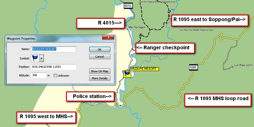
A map and GPS co-ords. of the Wildlife Resort 20km west of Pang Mapha/ Soppong. It makes a great cheap base for exploring the very north west corner of Thailand, with unspoiled hill tribe life.


willdlife resort map.jpg
 
Back
Top Bottom