Captain_Slash
Community Manager
- Joined
- Jun 28, 2011
- Bikes
- BMW 310GS Honda Wave 125 Honda MSX 125
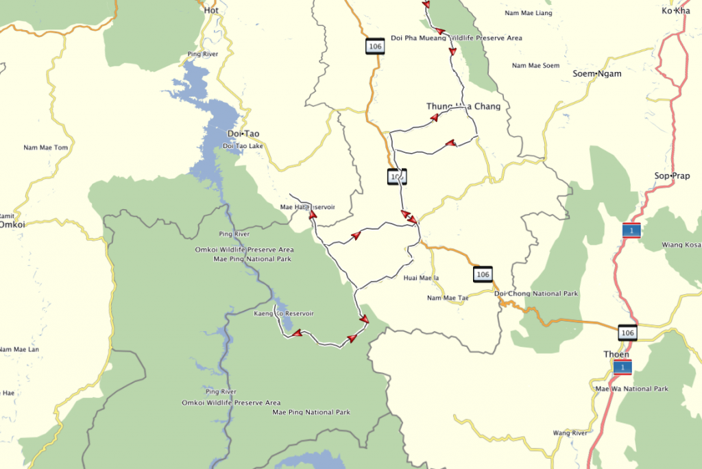
The route 116, 1033, 4010, 1184, 4044/1010, 4022, 106, 1087, 2059, 3008, 4038, 1219, 3183, 3019
Total distance 464 km

Along the 4010 and a shot of the Nam Mae Tha

Further along the 4010 and these kids are enjoying a swim


The Mae Moei reservoir


The Mae Ao Yai Ton Bon reservoir


A well laden bike on the 1184

This road is always a pleasure to ride


A bit of burning was taking place here and there

There were lots of workers out in the fields today in many places

Along the 4044/1010 is the Maepandang reservoir


Along the 1087 heading towards the Mae Ping National Park

As I cross over the bridge in Ban Koh Thung the water is higher than I have ever seen it here before

At the floating restaurant spot where I usually stop its under water, this dog is lying on the submerged road


Normally I ride through the barrier then up on to some higher ground but goodness knows how far that spot is under water now


I ride back taking a left onto the 3008

Stopping at a small temple roadside on the 4038 where the monks are energetically applying a coat of gold paint.
I have never rode along here in this direction before and spot a new temple in the hills that isnt visible travelling the other way


The Mae Hat reservoir is overflowing

Its not everyday that I see someone perched on a pair of step ladders out in a reservoir

He gets off and walks along carrying his gun


Shes getting a biy dusty and grubby now


Time to find this new temple and the entrance is right opposite where the Monks were busy painting


It was a steep climb up a loose stony track to get here and the view is great


Looking down at the Mae Hat

This is what was visible from the road and its at N17.48.889 E98.47.967


Along the 3008 heading towards Li and the bee hives


A few twists along here


From the 4022

Finally a shot from along the 1219.
Todays ride of 464 km was the longest so far on the KLX and with the wider seat plus utilising the Airhawk seat cushion was achieved in relative comfort

A hot spicy chicken jalfriezi and rice at the New Delhi Indian restaurant for dinner tonight, 160 Baht and this restaurant cooks this meal better than any other restaurant that I have ever tried
Get the GDB file here www.captainslash.com
Total distance 464 km

Along the 4010 and a shot of the Nam Mae Tha

Further along the 4010 and these kids are enjoying a swim


The Mae Moei reservoir


The Mae Ao Yai Ton Bon reservoir


A well laden bike on the 1184

This road is always a pleasure to ride


A bit of burning was taking place here and there

There were lots of workers out in the fields today in many places

Along the 4044/1010 is the Maepandang reservoir


Along the 1087 heading towards the Mae Ping National Park

As I cross over the bridge in Ban Koh Thung the water is higher than I have ever seen it here before

At the floating restaurant spot where I usually stop its under water, this dog is lying on the submerged road


Normally I ride through the barrier then up on to some higher ground but goodness knows how far that spot is under water now


I ride back taking a left onto the 3008

Stopping at a small temple roadside on the 4038 where the monks are energetically applying a coat of gold paint.
I have never rode along here in this direction before and spot a new temple in the hills that isnt visible travelling the other way


The Mae Hat reservoir is overflowing

Its not everyday that I see someone perched on a pair of step ladders out in a reservoir

He gets off and walks along carrying his gun


Shes getting a biy dusty and grubby now


Time to find this new temple and the entrance is right opposite where the Monks were busy painting


It was a steep climb up a loose stony track to get here and the view is great


Looking down at the Mae Hat

This is what was visible from the road and its at N17.48.889 E98.47.967


Along the 3008 heading towards Li and the bee hives


A few twists along here


From the 4022

Finally a shot from along the 1219.
Todays ride of 464 km was the longest so far on the KLX and with the wider seat plus utilising the Airhawk seat cushion was achieved in relative comfort

A hot spicy chicken jalfriezi and rice at the New Delhi Indian restaurant for dinner tonight, 160 Baht and this restaurant cooks this meal better than any other restaurant that I have ever tried
Get the GDB file here www.captainslash.com


