Convergence of smart phones as real GPS's

KTMphil

Senior member
Joined
Jan 11, 2011
Location
Chiang Mai, Thailand
Bikes
2007 KTM 990 Adventure Suzuki DRZ 400
There are currently 3, popular, smart phone, operating systems that most people have one (or more) of. The phone hardware used is becoming irrelevant assuming the phone's processor is up to the job:


1. I-Phone/ Apple

2. Android / Samsung, Sony, HTC etc.....

3. Windows mobile Phone/ Nokia the biggest vendor


Some smart phones are NOT real gps's, meaning they don't have the ability/ hardware to calculate your position from a set of satellite signals. They will only be able to calculate your position from either triangulating from cell phone towers (so you'll always need phone signal to get your position) or from a wifi's router connection that the phone is connected too. So hugely important, if planning to use the phone as a real GPS to check that the hardware in the smart phone does have a GPS receiver.


With location app software development exploding, so that the right commercial locations are put in front of your face on your phone screen, this has quickly metamorphosed the smart phone from a GPS toy into a really useful GPS tool - Garmin must be terrified about their consumer market for sure.


If you're a serious traveler, meaning that you're often going to new countries or are often out of cell data range, then you can't rely on Google Maps and other cloud/ online cartography as once you've lost signal, you'll no longer have map data on your phone screen. The new country you visit may not have a data plan available on their SIM card so again no map data from online services or if it's a 3rd world country maybe terrible cell signal coverage etc.... So this is why downloadable maps for your smart phone are very useful.


For Android users OSMAND/ the OSM map app is very useful, specific countries can be downloaded and you'll have a real GPS working on your smartphone, link below:


Welcome To OsmAnd


track-user.png


As far as I'm aware, the superb Nokia Here Maps, which are downloadable, are still not available for Android, but will be coming for sure, more below:


Nokia HERE apps for Android and iOS - GSMArena.com news


We used the Sygic Mapping Software to get us into Bangkok on an android Galaxy S5 & it worked amazingly well
 
This brings us to the Windows Mobile operating system, Nokia being the market leader with Microsoft's backing. If you're using a GPS, you want the screen to be as big and bright as possible. In Thailand, the Nokia Lumina 1320, which has a 164mm/ 6" wide screen is on sale for 9,999 with a free external battery top-up plug-in (worth 1,500 Bht).

300 bucks and you've got yourself a great GPS & smart phone. Downside of going the Windows Mobile smart phone route, is that there is still only a small percentage of apps available versus android & apple but all the necessary messaging, email, social media, browser & mapping apps are there.


Nokia-Lumia-1320-front-png.png


I've been testing this as a GPS & i'm highly impressed with the fast, position fix time and accuracy.


OSM is available for Windows Mobile, i havnt downloaded it yet link below:


GeoNET | Windows Phone Apps+Games Store (United States)


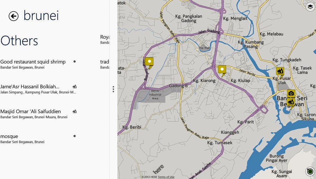
The Nokia Here map software is outstanding, individual countries are downloadable for use offline. Below was the Nokia Here map that I downloaded for Brunei and used off-line, it was perfect, very user friendly.


brunei here maps_edited.jpg


Waypoints/ POI are all easily saved and sync with your Nokia account, so can be opened seamlessly on your tablet or computer using Nokia Here software on those other devices, all pretty slick. Long/ Lat co-ords of all POI are available.


With the Nokia Lumina 1320 being a real GPS, routing to a desired location was a piece of cake.
 
Gave it a quick test as a real GPS on the Airbus 320 flight from Bangkok to Chiang Mai. Below is just as the plane took off - 289 km/hr


10532928_10153115678938345_2170976846694897707_n.jpg


Up at cruising speed 745 km/hr, this is the first gps i've had that has worked on a plane at 33,000 feet

]


Headed NNE over Doi Tao, was really interesting to know exactly what was below you


wp_ss_20140818_0003.png by Triangle Golden 007, on Flickr


Looks like we went way west to get around this storm


995072_10153115677843345_3677176240667717429_n.jpg


Putting the brakes on (559 km/hr) as we approach Chiang Mai over Lampang


wp_ss_20140818_0004.png by Triangle Golden 007, on Flickr


Touching down in Chiang Mai 247 km/hr - GPS worked all the way there, I was quite astonished.


It even recorded the distance correctly, 610km and the moving time


10626500_10153115677438345_3778262185342580818_n.jpg
 
It seems like BT GPS receivers might be a cheap way to have a very precise GPS on your smartphone.

Here is a good example:
BT-Q818XT


And here is a good article on GPS accuracy on smartphones and tablets.

from
Smartphones, Tablets and GPS Accuracy | ArcGIS Blog

"
Implementing mobile solutions that target the needs of your field workforce, that leverage your investment in the ArcGIS platform, and are available on the most modern and cost effective device platforms is critical when defining your mobile strategy.
Location is important and depending upon what you are mapping, locational accuracy can make or break a GIS. When considering the use of smartphone and tablet platforms one of the first questions you may ask is - how accurate is the GPS?? The answer to this question will shape the decision you make on device platforms. Or will it??
Cellular-enabled smartphones and tablets include an integrated GPS chip-set manufactured by companies like Qualcomm, Broadcom, CSR and others. These chip-sets are designed first for power consumption, second for time to fix and third for locational accuracy. What we found in our testing is that locational accuracy is pretty much the same regardless of manufacturer. In the open sky, mapping with several devices approximately90% of all positions collected fell within 3m of our baseline. These results were not too shabby really!In canopy conditions where we encountered significant multi-path interference from the receiver, results were considerably worse.
Most of the chip-sets support GNSS (Global Navigation Satellite System) which means they support both the United States NAVSTAR GPS satellites and the Russian GLONASSsatellites. That means you have a better constellation of satellites to draw from when you are in the field.
Next we connected our smartphones to external GPS receivers that were considered "consumer grade". These chip-sets are designed first for locational accuracy, second for time to fix, and third for power consumption. Here we found that you can purchase a variety of receivers that connect either directly to the device or via Bluetooth and most with SBAS capabilities! In the open sky, virtually all positions captured (99%) were within3m and almost 70% were within 1m of our baseline! As expected, positions degraded in canopy conditions but overall were much better!
Finally we connected an iPhone 4s to a high-accuracy, dual-frequency, survey-grade receiver from Altus Positioning Systems using a commercial product called GPS Cablefrom Aman Enterprises Inc. The GPS Cable will create an external connection to virtually any external GPS receiver using RS-232 and stream NMEA to the location manager on your smartphone. This replaces the location source in the same fashion as the external "consumer grade" GPS device does. Not to embarrass the other receivers we tested, and to ensure that we were only using the receiver itself and not supplementing our source using NTRIP (which we could have done), we chose to only map using SBAS and not fully leverage the true capabilities of the receiver. Even so we found that virtually all positions (over 92%) were within 1m!!
A couple of additional points worth mentioning - PPP (Precise Point Positioning) is becoming a reality and with it you can achieve centimeter level positioning directly from a satellite lock! This is a great solution for mapping efforts that require high accuracy, do not want to post-process positions, and do not have access to RTK networks.
So before you consider spending a fortune on mobile devices from hardware vendors that promise sub-meter accuracy with a complicated field to office workflow, consider your field needs and the possibilities of using a smartphone instead! Couple your hardware decisions with the Collector for ArcGIS app and implement a great low cost field data collection solution for your field staff that have not been trained in the underpinnings of high accuracy GPS positioning and want to collect data on a modern device!
To look at some of our tests, check out this web map. Let us know what you think and what you would like to see regarding device testing from Esri.
Mobile Team
"
 
Back
Top Bottom