A Myitkyina (Kachin State, Myanmar) meander

KTMphil

Senior member
Joined
Jan 11, 2011
Location
Chiang Mai, Thailand
Bikes
2007 KTM 990 Adventure Suzuki DRZ 400
A good riding friend had some good reasons (which you'll see below), to visit the untouched Kachin State, Myanmar & specifically it's capital, the town of Myitkyina (pronounced "Mich-in-na").


The bride-to-be in her traditional Lisu attire, looking fabulous, on the banks of the Irawaddy River


IMG_0990_edited by Triangle Golden 007, on Flickr
 
Seeing as I don't know anyone, including my real adventuring friends, that have ever been there, a couple of orientation maps so we know where we are.


Myitkyina, Kachin State, Myanmar, is about a 1 hour airplane flight north of Mandalay & is around 50km from the Chinese border (Chinese border town - Pianmazhen)


Myitkyina txt by Triangle Golden 007, on Flickr


The town of Myitkyina is on the banks of the famous Irawaddy River


Myitkyina. zoom by Triangle Golden 007, on Flickr
 
I was surprised Peter didn't need a travel permit in advance for this region, only a Myanmar visa, considering the problems in the there (more below). You are restricted to very specific areas within Kachin State, with military checkpoints every few Km's to keep you where you should be.


IMG_1362_edited by Triangle Golden 007, on Flickr


IMG_1359_edited by Triangle Golden 007, on Flickr


The travel restrictions are VERY clearly marked around the town, in Myannmar, English & Chinese (I gave Pete some pointers on what would be good to photograph for a story, he did a great job!!)


IMG_1116_edited by Triangle Golden 007, on Flickr
 
Myitkyina


The missionaries had found their way to Kachin State in the early 1900's, the area is primarily Christian, with the churches having a Roman Catholic feel to them. Being so close to the Chinese border, it has always been an important trading town. Resources are jade, gold, teak, forestry products and agriculture products.

Apparently, a huge, 4 meter long piece of jade was discovered there quite recently & was quickly confiscated by the military!


It was an important military post in WW II. You may remember recently there were rumors of spitfire airplanes buried underground in the area which unfortunatly were unfounded, link below:

Hope Fades in Burma Search for Buried Spitfires


Japanese forces captured the town and nearby airbase during World War II in 1942. In August 1944, Myitkyina was recaptured by the Allied forces under General Joseph Stilwell after a prolonged siege and heavy fighting betweenNationalist Chinese divisions, the Chindits, and Merrill's Marauders of the Northern Combat Area Command and the besieged elements of the 33rd Imperial Japanese Army under General Masaki Honda. The town was strategically important not only because of its rail and water links to the rest of Burma, but also because it was on the planned route of the Ledo Road.


Myitkyina - Wikipedia, the free encyclopedia
 
The Kachin Independence Army (Kachin: ShangLawt Hpyen)


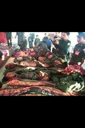
The Kachin region is still in turmoil with ongoing fighting & conflicts, hence the strict travel restrictions. 3 days before Pete left for Myitkyina, 30 rebels were killed in Liaza, which is just 50km from Myitkyina.


soldiers dead.jpg


The Kachin Independence Army was formed on February 5th, 1961 in response to a military coup in Burma led by General Ne Win, who attempted to consolidate Burmese control over regions on the periphery of the state which were home to various ethnic groups. From 1961 through 1994, the KIA fought a grueling and inconclusive war against the Burmese junta. Originally the KIA fought for independence, but now the official KIA policy goal is for autonomy within a federal union of Burma.[SUP][citation needed][/SUP]
The 1994 ceasefire agreement between the KIA and the Burmese junta froze the conflict in place.[SUP][citation needed][/SUP] The KIA has not disarmed or surrendered and continues to recruit, train and mobilize soldiers.[SUP][2][/SUP] Prior to the ceasefire, the KIA was predominantly a low-tech guerrilla force, but peace has provided the breathing room to establish a military academy and to design rigorous officer training programs.[SUP][3]


KIA-soldiers-at-Manau-festival.jpg


[/SUP]

The KIA is fully funded by the KIO, which raises revenue through taxes (in their area) and trading resources such as jade, timber and gold. Although well equipped for jungle warfare, the KIA does not have much modern weaponry.[SUP][citation needed][/SUP] Their rifles are a motley collection of AK-47s, home-made rifles such as a KA-07, and commanders claim to have some artillery. KIA headquarters are located outside the town of Laiza, in southern Kachin state near the Chinese border.[SUP][2][/SUP] Former headquarters, located at Pajau, are a 2 to 3 hour drive from Laiza, high in the mountains along the border.[SUP][citation needed]


Kachin-burma-KIA_0.jpg


[/SUP]

Although the ceasefire between the government and the KIA has endured since 1994,[SUP][4][/SUP] in 2009 many Kachins expected a renewed outbreak of war in conjunction withelections scheduled for 2010. The Military junta that runs Burma demanded that all ethnic armies disarm before the 2010 general elections because the new constitution requires only one army in Burma. According to Gen. Gam Shawng Gunhtang, the chief of staff of the KIA, the demands to disarm were "not acceptable" because he regards that disarming KIA does not guarantee peace between the Military junta and KIA.[SUP][5][/SUP] In February 2010 Alastair Leithead reported for the BBC that KIA's Chief of Staff, Maj Gen Gam Shawng said "I can't say if there will be war for sure, but the government wants us to become a border guard force for them by the end of the month", and "We will not do that, or disarm, until they have given us a place in a federal union and ethnic rights as was agreed in Panglong Agreement in 1947".[SUP][2]


KIA-.jpg


[/SUP]

In October 2010 KIA commanders informed the BBC that they have "10,000 regular troops and 10,000 reservists", but the BBC had no way to confirm this,[SUP][4][/SUP] and in 2009 Thomas Fuller of the New York Times estimated their numbers at about 4,000 active soldiers.[SUP][5][/SUP] The soldiers are divided into five brigades, plus one mobile brigade. Most are stationed in bases close to the Chinese border, in strips of territory held by the KIO.[SUP][5][/SUP] One brigade is stationed in northern Shan state, where there is a large Kachin population
 
Pete's first meal, note the full head in the soup


IMG_0805_edited by Triangle Golden 007, on Flickr


The main road through the center of town was built in colonial times and is kept in excellent condition, with trimmed grass and hedges, the rest of the roads are in poor condition


IMG_0352_edited by Triangle Golden 007, on Flickr


These are free drinking water urns from the generosity of the locals, an interesting sign of what kind of people inhabit region


IMG_0447_edited by Triangle Golden 007, on Flickr


There are NO fuel/ gas stations. Motorcycle fuel is dispensed from water and whisky bottles, there are 5 gallon jugs for cars


IMG_0348_edited by Triangle Golden 007, on Flickr


IMG_0346_edited by Triangle Golden 007, on Flickr
 
Internet is almost non-existent, Pete actually had to come home early to get some important data transferred. Power cuts are a daily occurrence & tend to last about 2 hours, usually from customer overload.


Inconsistency of voltage supply easily damages electrical equipment ( as the voltage drops, the amps needed to keep the power (watts) the same increases burning out electric motors and components with heat), so voltage regulators are everywhere to protect fridge compressors etc....


It looks like this might also convert 220 v to 110v


IMG_0479_edited by Triangle Golden 007, on Flickr
 
"You can always quickly judge a village by the condition of the dogs" - so true


Here they all looked healthy and happy, a sign of good natured people around them


IMG_1087_edited by Triangle Golden 007, on Flickr


IMG_0600_edited by Triangle Golden 007, on Flickr


IMG_0674_edited by Triangle Golden 007, on Flickr


Do they get any happier than this?


IMG_1086_edited by Triangle Golden 007, on Flickr


Apparently, there is a tradition to eat dog once a year, it's kind of an old wives tale/ tradition that if you eat dog before winter you will stay warm. They do not eat the family pets.


Big families living in compounds, cooking it done on huge stoves with charcoal and firewood (sometimes rice husk is used). Firewood burns at a higher temperature and blackens the cookware very quickly


IMG_0965_edited by Triangle Golden 007, on Flickr
 
Without ever seeing anything about the area, its always fascinating to see what kind of houses people decide to design in these remote, cut off regions. This is a typical house. Most are raised, which keep the chickens, dogs & insects at bay, woven bamboo walls which don't hold heat, keep the place cool and tin roofs.


IMG_1462 by Triangle Golden 007, on Flickr


Ox & cart are still heavily in use around harvest time


IMG_1405 by Triangle Golden 007, on Flickr


IMG_1260 by Triangle Golden 007, on Flickr


IMG_1254 by Triangle Golden 007, on Flickr


IMG_1398 by Triangle Golden 007, on Flickr


Once off the main drag through town, most roads are a hard packed sand/ mud, combined with large oval pebbles that have been brought up from the Irawaddy River


IMG_1401 by Triangle Golden 007, on Flickr


IMG_1425 by Triangle Golden 007, on Flickr


Chinese farm vehicles are making their way in for the more affluent farmers, they consist of the usual engine that can be used for various power take off applications


IMG_1335 by Triangle Golden 007, on Flickr


There area has a significant Pineapple harvest


IMG_1415 by Triangle Golden 007, on Flickr


Also rice


IMG_1411 by Triangle Golden 007, on Flickr


IMG_1408 by Triangle Golden 007, on Flickr


Every night bird traps are set


IMG_1407 by Triangle Golden 007, on Flickr


Obviously, being on the Irawaddy River, there;s significant fishing


IMG_1302 by Triangle Golden 007, on Flickr


IMG_1308 by Triangle Golden 007, on Flickr


Making charcoal - burning wood & reducing the oxygen available by burning the wood inside 55 gallon drums with a small breather to allow small amounts of new oxygen, just enough to keep the burning going


IMG_1261 by Triangle Golden 007, on Flickr


New market areas are always fascinating - oranges & apples, she wasnt too happy about having her photo taken


IMG_1347 by Triangle Golden 007, on Flickr


IMG_1340 by Triangle Golden 007, on Flickr


Basic hotel rooms can be sourced for around 800 bht a night with own bathroom


IMG_1338 by Triangle Golden 007, on Flickr
 
... 30 rebels were killed in Laiza, which is just 50km from Myitkyina.
Yes, one man's rebel is another's freedom fighter... Those people were killed in an an apparently unprovoked attack by the Tatamadaw .. despite apparent "peace" talks. Things get very messy and complex up in those hills, and local commanders seem to do what they like... When I was up there in the beginning of this year, the KIO was holding big meetings in the main park of town with no interference from the military.. yet there were lots of areas where we weren't permitted to travel by road....
 
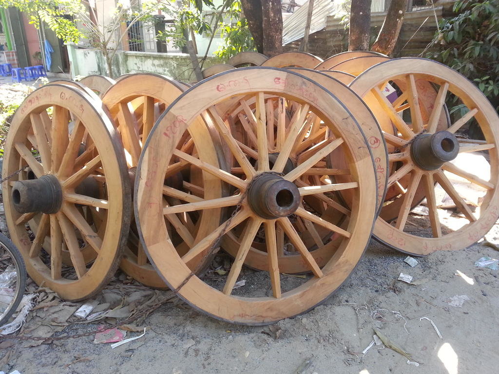
If your ox cart gets a broken wheel, I know just where you can get a brand new one in Myitkyina, down the road from the hotel I used .. 0000162.jpg

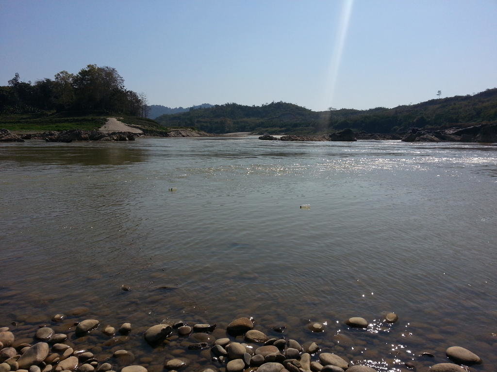
but as for fishing in the Irrawaddy? .. the future is looking bleak if the Chinese get to recommence their giant dam at the confluence ( off to the right in this picture )
0000170.jpg

There's some great potential adventure riding up there, if a real peace deal can be struck so permits can be had...but I wouldn't hold my breathe.. :(
 
Wedding day tomorrow, this is how the brides parents looked when they were married, one is Lisu, the other Kachin


15872618386_145e3c224c_b.jpg
[/URL]IMG_0392_edited by Triangle Golden 007, on Flickr[/IMG]


Because of the strict Christian religion in the area, they were not allowed to get married in the local church because they had "lived" together beforehand, so a local community hall would be used.


IMG_0900_edited by Triangle Golden 007, on Flickr


The traditional wedding dress is fantastic


IMG_0949_edited by Triangle Golden 007, on Flickr


IMG_0871_edited by Triangle Golden 007, on Flickr


Then for some great shots around the town, here on the banks of the Irawaddy River


IMG_0993_edited by Triangle Golden 007, on Flickr


IMG_1023_edited by Triangle Golden 007, on Flickr


IMG_1020_edited by Triangle Golden 007, on Flickr


The rural shot


IMG_1056_edited by Triangle Golden 007, on Flickr


The motorcycle trail back up from the Irawaddy River back to town


IMG_1036_edited by Triangle Golden 007, on Flickr


Hang on


IMG_1178_edited by Triangle Golden 007, on Flickr
 
Last edited:
The crazy foreigner getting some curious looks'


IMG_0787_edited by Triangle Golden 007, on Flickr


Would be fun to find this. It's on the wall of a friends house


IMG_1118_edited by Triangle Golden 007, on Flickr


Looks like its the famous Ledo-Burma road from WW II


Screenshot_3 by Triangle Golden 007, on Flickr


The Ledo Road (Hindi: लेडो रोड, Burmese: လီဒိုလမ်းမကြီး, Chinese: 中印公路) (from Ledo, Arunachal Pradesh, India to Kunming,Yunnan, China) was built during World War II so that the Western Allies could supply the Chinese as an alternative to the Burma Road which had been cut by the Japanese in 1942. It was renamed the Stilwell Road, after General Joseph Stilwell of the U.S. Army, in early 1945 at the suggestion of Chiang Kai-shek. It passes through the Burmese towns of Shingbwiyang, Myitkyina andBhamo in Kachin state.[SUP][1][/SUP]
In the 19th century British railway builders had surveyed the Pangsau Pass, which is 3,727 feet (1,136 m) high on the India-Burma border, on the Patkai crest, above Nampong, Arunachal Pradesh (then part of Assam). They concluded that a track could be pushed through to Burma and down the Hukawng Valley. Although the proposal was dropped, the British prospected the PatkaiRange for a road from Assam into northern Burma. British engineers had surveyed the route for a road for the first eighty miles. After the British had been pushed back out of most of Burma by the Japanese, building this road became a priority for the United States. After Rangoon was captured by the Japanese and before the Ledo Road was finished, the majority of supplies to the Chinese were delivered via airlift over the eastern end of the Himalayan Mountains known as the Hump.


African-americans-wwii-009.jpg


For the first convoys, if they turned right, they were on their way to Lashio 100 miles (160 km) to the south through Japanese-occupied Burma. If they turned left, Wanting lay 60 miles (100 km) to the north just over the China-Burma border. However, by late 1944, the road still did not reach China; by this time, tonnage airlifted over the Hump to China had significantly expanded with the arrival of more modern transport aircraft.
In late 1944, barely two years after Stilwell accepted responsibility for building the Ledo Road, it connected to the Burma Road though some sections of the road beyond Myitkyina at Hukawng Valley were under repair due to heavy monsoon rains. It became a highway stretching from Assam, India to Kunming, China 1,079 miles (1736 km) length. On 12 January 1945, the first convoy of 113 vehicles, led by General Pick, departed from Ledo; they reached Kunming, China on 4 February 1945. In the six months following its opening, trucks carried 129,000 tons of supplies from India to China.[SUP][6][/SUP] Twenty-six thousand trucks that carried the cargo (one way) were handed over to the Chinese.[SUP][6][/SUP]
As General Chennault had predicted, supplies carried over the Ledo Road at no time approached tonnage levels of supplies airlifted monthly into China over the Hump.[SUP][7][/SUP] The road, however, complemented the airlift. The capture of the Myitkyina airstrip enabled the Air Transport Command "to fly a more southerly route without fear of Japanese fighters, thus shortening and flattening the Hump trip with astonishing results."[SUP][8][/SUP] In July 1943 the air tonnage was 5,500 rising to 8,000 in September and 13,000 in November.[SUP][9][/SUP] After the capture of Myitkyina deliveries jumped from 18,000 tons in June 1944 to 39,000 in November 1944.[SUP][10][/SUP]
In July 1945, the last full month before the end of the war, 71,000 tons of supplies were flown over the Hump, compared to only 6,000 tons using the Ledo Road; the airlift operation continued in operation until the end of the war, with a total tonnage of 650,000 tons compared to 147,000 for the Ledo Road.[SUP][4][/SUP][SUP][7][/SUP] By the time supplies were flowing over the Ledo Road in large quantities, operations in other theaters had shaped the course of the war against Japan.[SUP][3][/SUP]
There was a mile sign at the start of the Ledo Road with the following information:[SUP][11][/SUP][SUP][12]


Allied_lines_of_communication_in_Southeast_Asia%2C_1942-43.jpg
[/SUP]


Source: http://en.wikipedia.org/wiki/Ledo_Road
 
Many tricky spots riding out of town


IMG_0602_edited by Triangle Golden 007, on Flickr


IMG_1422 by Triangle Golden 007, on Flickr


Water wells are everywhere, the water does not need to be boiled for drinking which is quite unusual


IMG_0461_edited by Triangle Golden 007, on Flickr


A typical well will take a solid 2 weeks to dig


IMG_0459_edited by Triangle Golden 007, on Flickr


Natural rubber plantations are still very common


IMG_1156_edited by Triangle Golden 007, on Flickr


The press to flatten the rubber before drying


IMG_1157_edited by Triangle Golden 007, on Flickr


Dinner, pork leg soup, very tasty


IMG_0847_edited by Triangle Golden 007, on Flickr
 
After WW II, if you could prove you had helped the American military in WW II, by showing your American medals, you were given money. There was a scandel whereby the translators were scamming the locals and keeping 90% of the money. They eventually got caught by showing unusual wealth, new houses etc...


15872609576_f801b4f3a3_b.jpg
[/URL]IMG_0681_edited by Triangle Golden 007, on Flickr[/IMG]


Making slingshots bullets with a certian kind of mud. The bullets have to be perfectly round so that the trajectory can be aimed. A stone doesnt work as its not perfectly round and will fly a random course


IMG_0690_edited by Triangle Golden 007, on Flickr
 
That's about it. I was supposed to be on this trip, but a broken foot prevented me from going, I will go there for sure.
 
A few good ones i missed


For a special occasion, when a pig is slaughtered, specialist butchers are called in. There payment is the head of the pig which is on the fire


IMG_0635_edited by Triangle Golden 007, on Flickr


The pigs entrails in the basin to the left


IMG_0640_edited by Triangle Golden 007, on Flickr


Fresh coffee is abundant in the area


IMG_0518_edited by Triangle Golden 007, on Flickr


Doesnt get much fresher than this


IMG_0827_edited by Triangle Golden 007, on Flickr


Panning for gold on the Irawaddy


IMG_0549_edited by Triangle Golden 007, on Flickr


IMG_0552_edited by Triangle Golden 007, on Flickr


That's it
 
That's about it. I was supposed to be on this trip, but a broken foot prevented me from going, I will go there for sure.
Fantastic pics - thanks for whetting appetites! Having local connections, as on most trips, makes for more interesting experiences - seems like you'll be fine when you head there. If you can take a bike the 250 will be the go.. the KTM would be too much of a beast on many roads/tracks there.
 
Excellent. Thanks
 
Looks more like a deisal roller to me as has no boiler, chimney etc, but a road roller in very good condition seeing it is so old.
 
Brilliant stuff. Would love to visit the area. Stillwell was a man of iron. Refused to be evacuated by plane from Shewbo early in 1942. Instead, led a column of 140 Yanks, Poms, Chinese and Indian soldiers and civilians, including 19 Karen nurses, on a 3 week trek to India. They crossed the Chindwin at Homalin and from there made it to Imphal. Stillwell led from the front. A true legend.
 
Info?

Hiya, I've been living in Myanmar for ages and have wanted to do a bike ride up into Kachin State, but everytime I check with "official sources" am told that foreigners are not allowed to travel by road there, and can only fly in......so how did you manage it?
 
Back
Top Bottom