11 day Long tien > Thasi > Nam Kading river crossing ? & Nakai Dam > HCMT in Vietnam
HI guys any input and pointers much appreciated on this route .
It's probably made up of stuff i looked at in awe on here and by filling in the gaps with my GTRiders Laos map 2012 .
OVERVIEW .10 of us are attempting to do this on crappy tourist bikes , wins dreams stuff to make it quite difficult for ourselves .
(have got very lost , travelled on dust , dirt , sand , almost quicksand , roads under construction , on various other trips so like a challenge ) The sort of places you think this is totally wrong haven't seen anyone for hours , up to your boots in sand and then a local comes past with his entire family pointing forwards an smiling !
but if you think it totally ridiculous please say .
Apologies I'm a bit of a div on computer so i hope the other link works
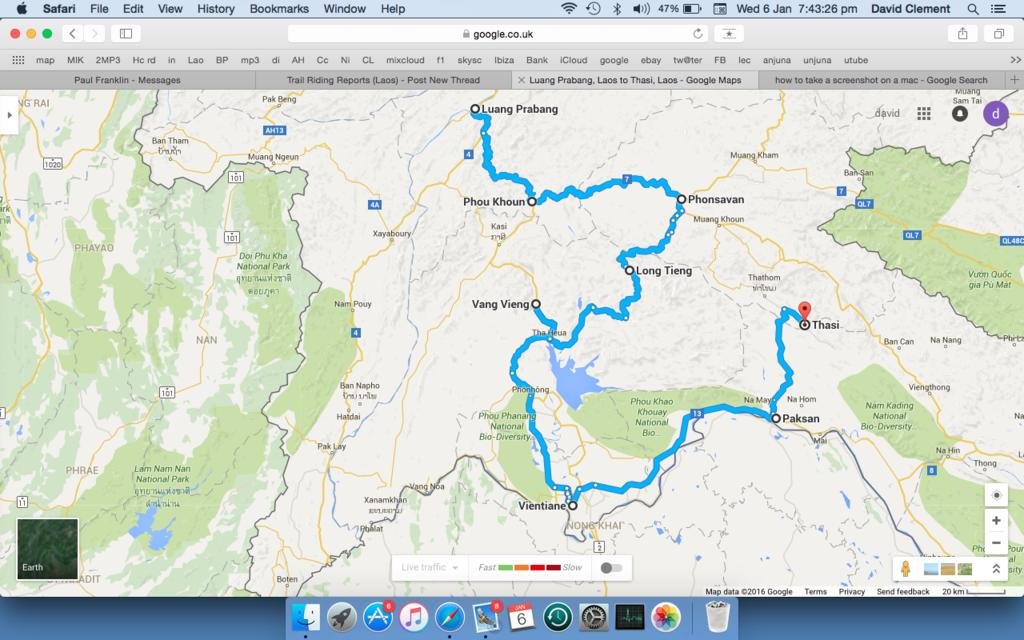
https://goo.gl/maps/9p3nZXQRgas
This is the actual ride leaving Sunday 10th April
10th Luang Prabang > Phou Khoun 80 miles ROAD 13
11th Phonsavan > 83 miles ROAD 7
12th Long Tien > 90 miles stay @ Mr saysamone GH **GOOGLE MAP AND GT MAP HAVE THIS COMPLETELY DIFFERENT **
13th Vang Vien > 100 miles ROAD 13
14th Vientiane >100 miles New years eve ROAD 13
15th Rest day New years day
16th Paksan > 90 miles ROAD 13
17th Thasi down in Nam Ka National park RED ROAD > ORANGE ROAD > PURPLE DOTS (dust track on GTMap)
18th Viengthong > 55 miles ( 2 river crossings / bomb boats ? @ The bak) RED ROAD
19th Lak Sao > 85miles ( visit Dam 2 and stay @ Phosy Thalang guest house ) ROAD 8S > E1
20th Nakai > Border @ Na Phao / Chalo > 80 miles ROAD E1 > 12
21st pick up section of National park / HCM trail i travelled last year > Da Nang
ERRORS ON MAPS
LONG TIEN TO VANG VIEN .= google map says it joins Long Tien to Sana Somboun to Houay Xay to Tha Heua BUT GT MAPS puts lake Nam Nagum much higher and in the way ? is it possible to do this ?
IS 100 miles a day to much or to little ? OR will it give us plenty of time to look at things ( get bikes fixed daily)
We like to stop on the hour every hour for a drink ( if poss) or at least stretch our legs and give our backsides a rest.
The GTRider map is good so assume thats like the paper bible of travelling or should i by a Midnight mapper or someone GPS ?
( i don't actually have a a gps at the mo but could invest )
Will we be stuffed for accommodation on these route ? Any guest house info gladly received .
Any points of interest , tanks , helicopters , water crossings , good pubs , etc most grateful noted .
What is Bomb Boats marked on the GTmap at Lak Ha ?
Mank thanks for taking the time to look at this route
Cheers
Dave in England .
HI guys any input and pointers much appreciated on this route .
It's probably made up of stuff i looked at in awe on here and by filling in the gaps with my GTRiders Laos map 2012 .
OVERVIEW .10 of us are attempting to do this on crappy tourist bikes , wins dreams stuff to make it quite difficult for ourselves .
(have got very lost , travelled on dust , dirt , sand , almost quicksand , roads under construction , on various other trips so like a challenge ) The sort of places you think this is totally wrong haven't seen anyone for hours , up to your boots in sand and then a local comes past with his entire family pointing forwards an smiling !
but if you think it totally ridiculous please say .
Apologies I'm a bit of a div on computer so i hope the other link works
https://goo.gl/maps/9p3nZXQRgas
This is the actual ride leaving Sunday 10th April
10th Luang Prabang > Phou Khoun 80 miles ROAD 13
11th Phonsavan > 83 miles ROAD 7
12th Long Tien > 90 miles stay @ Mr saysamone GH **GOOGLE MAP AND GT MAP HAVE THIS COMPLETELY DIFFERENT **
13th Vang Vien > 100 miles ROAD 13
14th Vientiane >100 miles New years eve ROAD 13
15th Rest day New years day
16th Paksan > 90 miles ROAD 13
17th Thasi down in Nam Ka National park RED ROAD > ORANGE ROAD > PURPLE DOTS (dust track on GTMap)
18th Viengthong > 55 miles ( 2 river crossings / bomb boats ? @ The bak) RED ROAD
19th Lak Sao > 85miles ( visit Dam 2 and stay @ Phosy Thalang guest house ) ROAD 8S > E1
20th Nakai > Border @ Na Phao / Chalo > 80 miles ROAD E1 > 12
21st pick up section of National park / HCM trail i travelled last year > Da Nang
ERRORS ON MAPS
LONG TIEN TO VANG VIEN .= google map says it joins Long Tien to Sana Somboun to Houay Xay to Tha Heua BUT GT MAPS puts lake Nam Nagum much higher and in the way ? is it possible to do this ?
IS 100 miles a day to much or to little ? OR will it give us plenty of time to look at things ( get bikes fixed daily)
We like to stop on the hour every hour for a drink ( if poss) or at least stretch our legs and give our backsides a rest.
The GTRider map is good so assume thats like the paper bible of travelling or should i by a Midnight mapper or someone GPS ?
( i don't actually have a a gps at the mo but could invest )
Will we be stuffed for accommodation on these route ? Any guest house info gladly received .
Any points of interest , tanks , helicopters , water crossings , good pubs , etc most grateful noted .
What is Bomb Boats marked on the GTmap at Lak Ha ?
Mank thanks for taking the time to look at this route
Cheers
Dave in England .