Captain_Slash
Community Manager
- Joined
- Jun 28, 2011
- Bikes
- BMW 310GS Honda Wave 125 Honda MSX 125
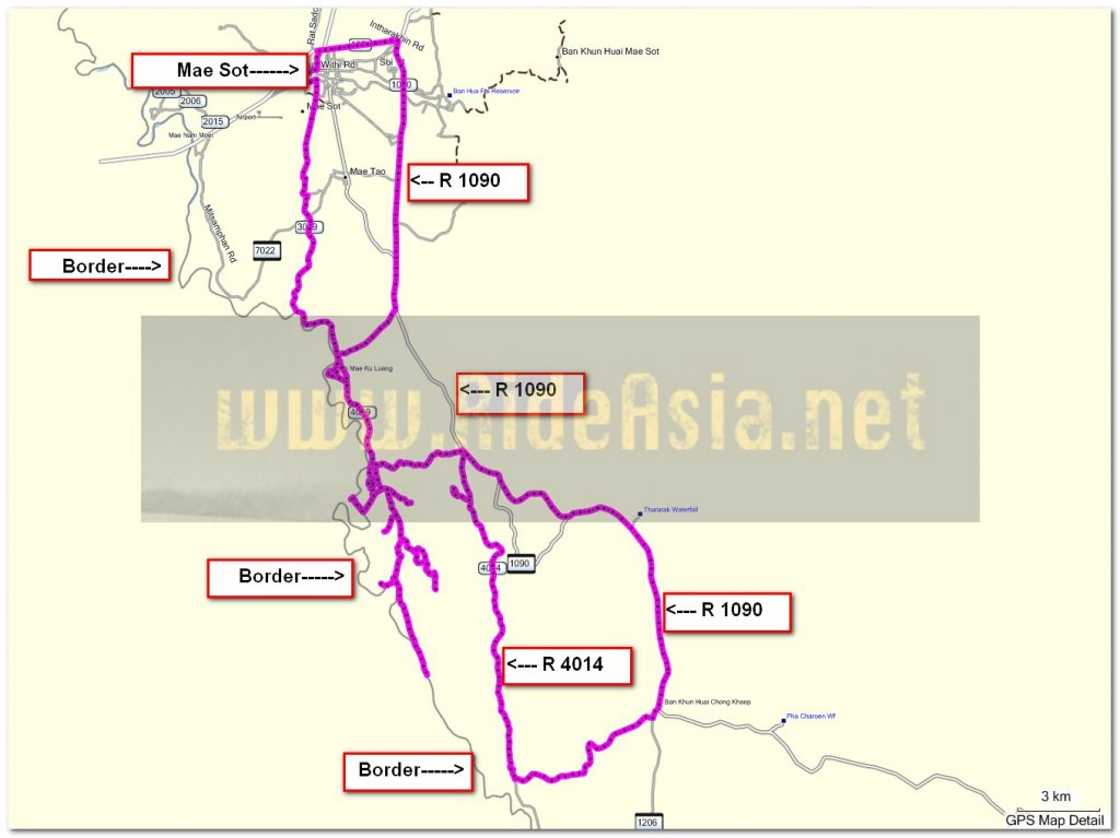
The Route 1090, 4019, 4014, 4008, 3059
Total Distance 134 km

A shot of the Moei from along the 3059

Now riding on the 4019


I ride the roads near to the Burmese border and at N16.34.286 E098.35.114 the road turns to unpaved and goes down to the Moei


Some cross over by boat

I thought I would pick one of these up to see how heavy it was, I soon gave up on that idea

This guy walked over

I ride back to the paved surface then the unpaved starts again at N16.34.503 E098.35.695


I rode through that, the heat was unpleasant and the smoke even more so but I wanted to get to the top of the hill to see if it was a good view or not

The view from the top wasnt so special and the Moei is hardly visible through the haze


Theres fires galore out here now and a heavy nights rainfall wouldnt go amiss

Time to fry up some tomatoes


A small shop out here on the dusty track but no fuel sold here


Plenty of kids here playing near the water


I ride close to the Moei a few times this morning following various tracks


While I am glad to be riding on a dry track this would have looked so much better three months ago


I ride south alongside the Moei and happen upon the newish shelter, I have rode off the ESRI map now but if I follow the Moei for long enough I will get back to an asphalt road

This lad gets out from the Moei and tells me the track finishes just past here


He was right, about 400 metres more and the track finishes, its not the fallen tree that halts progress but the large rocks just past it, not even a walking track now so its time to ride back


I try a couple more side tracks but everything turns to a dead end


After 25.2 km of dirt its back to paved


I spend the rest of an extremely hot day riding on asphalt, the temperature has really warmed up here over the last week, no cold starts in the morning now


Two large Cumberland sausages, double chips and onions at Krua Canadian for 140 Baht, truly lovely too
You can get the gdb file from my website here … http://www.captainslash.com
Total Distance 134 km

A shot of the Moei from along the 3059

Now riding on the 4019


I ride the roads near to the Burmese border and at N16.34.286 E098.35.114 the road turns to unpaved and goes down to the Moei


Some cross over by boat

I thought I would pick one of these up to see how heavy it was, I soon gave up on that idea

This guy walked over

I ride back to the paved surface then the unpaved starts again at N16.34.503 E098.35.695


I rode through that, the heat was unpleasant and the smoke even more so but I wanted to get to the top of the hill to see if it was a good view or not

The view from the top wasnt so special and the Moei is hardly visible through the haze


Theres fires galore out here now and a heavy nights rainfall wouldnt go amiss

Time to fry up some tomatoes


A small shop out here on the dusty track but no fuel sold here


Plenty of kids here playing near the water


I ride close to the Moei a few times this morning following various tracks


While I am glad to be riding on a dry track this would have looked so much better three months ago


I ride south alongside the Moei and happen upon the newish shelter, I have rode off the ESRI map now but if I follow the Moei for long enough I will get back to an asphalt road

This lad gets out from the Moei and tells me the track finishes just past here


He was right, about 400 metres more and the track finishes, its not the fallen tree that halts progress but the large rocks just past it, not even a walking track now so its time to ride back


I try a couple more side tracks but everything turns to a dead end


After 25.2 km of dirt its back to paved


I spend the rest of an extremely hot day riding on asphalt, the temperature has really warmed up here over the last week, no cold starts in the morning now


Two large Cumberland sausages, double chips and onions at Krua Canadian for 140 Baht, truly lovely too
You can get the gdb file from my website here … http://www.captainslash.com


