ROAD DEVELOPMENT AND ROAD CONSTRUCTION IN LAOS

Lone Rider

Blokes Who Can
Joined
Jan 29, 2011
Location
Chiangmai
Bikes
4 Wheels
Highway 14 (A, B, C, A1).

Highway14.jpg


Construction of the new road (Rd 14 A) west of the Mekong from highway 16 (Vangtao to Pakxe) to Champasack (Wat Pou) is going fast and it is expected that in a few months the whole road is asphalt.

Highway14001.jpg


From Wat Pou there is a good dirt road running further south up to the Cambodia border passing through the Sukhuma and Moonlapamok districts.

Highway14southofSukhuma.jpg


At Moonlapamok there is a big junction with the road to the east going to the ferry crossing (car ferry) linking with Rd 13, to the south goes to the border with an option to cross over to Don Kong (bikes only) while the road to the west goes in the direction of the border with Thailand

Highway14JunctionatMoonlapamok.jpg


Below is a screenshot from Google Earth which shows the new road shown from Pakse to Champassack, Sukhuma, Moonlapamok, crossing the Mekong and on to Don Kong.

Rd14.jpg
 
Re: Road Development and Construction in Laos

Thanks for all the new Laos information, we're headed to Laos next and will try to take a look here.
 
Road Development and Construction in Laos

Highway 15

Highway 15 runs from Saravane to Samoi near the Vietnam border and is being upgraded from unpaved tracks and trails to an asphalt road. This road is part of the Ho Chi Minh Trail

Highway15.jpg


Highway151.jpg

The asphalted part with the temporary road next to it.

Some 35 km is ready (asphalted) and another 15-20 km will soon be ready leaving another 25 km to go to Ta-Oi and about 80 km. to Samuoi.

Highway152.jpg


Highway153.jpg

View from the Ta-Oi side to the west
 
Lonerider - Great to see a report from tracks around south eastern Laos.

So how populated is the track after you are out of Saravan on the way to Ta Oi? Is it full of villages or sparsely populated? Did you attempt to go south to Ta OI? If so how was the track condition?

Great info, thanks for the report.
 
From Saravan to Ta-Oy I think there are about 15 villages along the road with those along the newly paved part growing in size. In addition several new sawmills, charcoal makers and a cement factory are operational and a new petrol station (Lao Fuel) was open about 20 km. along the new road from Saravan. Did not go south of Ta-Oy so don't know about the road conditions to the south.
 
RD 16 B SEKONG VIA DAKCHEUNG TO VIETNAM

Rd16ADB.jpg


This road runs from Sekong all the way to the Vietnam border and the Xekaman 3 Hydropower project along the border. The road was, and still is for a large part, a rough dirt road.

RD16B.jpg

The old road

GEDC0519A.jpg

Very nice views to both the north and south

The part from Dakcheung to the Vietnamese border (about 20 KM) is being built by a Vietnamese constractor and should be ready and asphalted this year.

However, the part from Sekong to Dakcheung (about 90 KM) is being constructed by a Lao contractor and is expected to be ready by 2013/2014. Last week some 35 km was completed to a certain extent but bridges, etc. still needed to be put in.

GEDC0522A.jpg

Road construction in progress about 30 km from Sekong

RD16B2.jpg

Road construction about 20 km from Sekong

At Sekong there is no bridge although the new road goes up to the river so in the future it can be expected that a bridge will be built. On the ferry looking at the Vangxang Sawan Sekong Hotel in Sekong.

FerryCrossingSekong.jpg


SekongHotel2.jpg

The same hotel in 2010 after typhoon Ketsana had dropped a lot of rain in Vietnam and the south of Laos (seen from Sekong town)
 
LR- a friend called Niko recently did R 4A from Hongsa to Xainyabouli, he said it is now asphalt/ tarmac ALL the way?

I did it 8 weeks ago and it was still sand/clay, do you know about this?
 
Haven't been there for some time (except for the very first part from Hongsa to the turn of to Luang prabang) so don't know.

The last time I did that road (probably late 2009) there were several short patches of asphalt but no activity going all. Looked like the government had run out of money as all the equipment was concentrated in a few places and with only a few people around to guard the equipment. However, basically the road was ready to be asphalted so I would not be surprised that it is now completely asphalted.

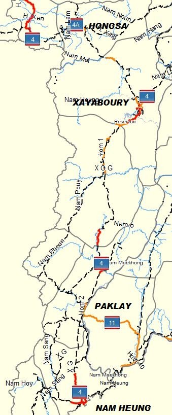
Xayaboury down south to Paklay and on to the border with Thailand was also partly asphalted already about 6 weeks ago or so.
 

Attachments

  • Hongsa via Xayaboury and Paklay to the Border with Thailand.JPG
    Hongsa via Xayaboury and Paklay to the Border with Thailand.JPG
    104.5 KB · Views: 2,572
i think he must be talking about the part south to Park Lay - i can't believe it's done already
 
RD 1D - Phonsavan to RD 8 (near Thabak)

Road 1D

RD1D.jpg

Screenshot from the GPS Map for Laos

This road is being upgraded and although there are still parts which are not very good, generally speaking they pose no problems although I must admit that I don't know the condition of the stretch from Thasi to Viengthong. A few weeks ago did this road in my truck and left Phonsavan at 7 in the morning and was in Paksan at 3 in the afternoon taking the turnoff at Thasi to Paksan. From Phonsavan to Muang Khoune is all asphalt and they are starting to asphalt the road from Muang Khoune southwards.

GEDC0602web.jpg

The road ready for the asphalt layer

The first 32 km from Khoune is smooth and assume that this part will have an asphaly layer before the raininy season starts. From there onwards, there are here and there short stretches where the road builders are still busy with blasting rocks to take out the shorp corners. Got stuck for some time behind a logging truck which could not make it up as it had been raining the day before.

GEDC0606web.jpg


GEDC0608web.jpg

Logging truck stuck on a sharp incline and had to be pulled over by a bulldozer

GEDC0609web.jpg

The road 39 kilometer south of M. Khoune

The turnoff in Thaviang to Xaysomboune is still narrow but bikes can now pass over the bridge while cars can cross the river but only in the dry season.

GEDC0610web.jpg


GEDC0614web.jpg

The bridge and the river crossing at the turnoff to Rd 5 to Xaysomboune

In Thasi you can head west to Muang Hueang and Pakse on a new road which is quite steep in some areas.

GEDC0615web.jpg


Although some of the bridges are ready, others are still under constructions but most of the river crossings should pose no problems for bikes.

GEDC0640web.jpg

The new bridge over the Nam Ngouang between Viengthong and Rd 8.

From Viengthong to Rd 8 the road is good and in a short while this whole stetch of the road will be asphalt

GEDC0637web.jpg

The wat on the hill in Viengthong
 
Re: RD 1D - Phonsavan to RD 8 (near Thabak)

Very interesting LR - looks like that logging truck was having some difficulty with the clay hill!
 
RD 1E from Gnommalath on Rd 12 to Lak Xao (Mueang Khamkheut) on Rd 8

Late March this year I traveled along this road on my way to Vientiane. Previously this road was all unpaved but the road from Gnommalath on Rd 12 up to the Nam Theun power station is now asphalt and from here to Nakai (Ban Oudomsouk) made out of concrete.

RD1E.jpg


From Oudomsouk up to the Nam Niau Bridge and the Forest Conservation Checkpoint the road is unpaved and OK. Previously this part of the road was very good as it was newly constructed to replace the old road partly which would become submerged by the Nam Theun II reservoir. However, overtime and after a few rainy seasons the road starts deteriorating and potholes appear.

NewroadalongNTII-1.png


NewBridgeNTII-1.png

The new road and the bridge at Ban Thalang over the Nam Theun II reservoir

Once past the Forest Conservation Checkpoint, the new road joins the old road which runs through the forest as a narrow unpaved road which generally is quite OK but in places also muddy.

GEDC0624d.jpg


About halfway there is a junction at N18 02.407 E105 03.157 with the road to the west going to the Nam Theun II Dam and to the east to Ban Phonsaat while straight on goes to Lak Xao

GEDC0625d.jpg

The road to the west to the Dam and nice views over the Nam Theun river to the Northwest

GEDC0627d.jpg

The road to Lak Xao from the junction

Once the road enters the plains to Lak Xao, the road bordered by rice fields on both sides deteriorates quite a bit and in the rainy season can be difficult to ride with lots of mud and deep ruts. About 10-15 km from Lak Xao on Rd 8 the road starts having a very patchy asphalt cover which continues till you reach Rd 8.

GEDC0628d.jpg


GEDC0629d.jpg

The last part to Lak Xao with patchy asphalt
 
NEW BYPASS AROUND LUANG PRABANG

(Adapted from KPL News - June 14, 2011) Luang Prabang province will spend more than 160 billion kip or US$20 million on the construction of an 18-km asphalted road to detour the town preventing heavy trucks entering into the town.

The two-layer asphalt road runs from Kok-ngiew (Kokngiou) to Phonesay (Phonxay) villages with installation of streetlight system and drainage system. The construction work by the Phousi Luang Prabang Road and Bridge Construction Company started on 27 May 2011 and is expected to be complete in 2015.

BypassLPB.jpg

The exact location of the new bypass is not known but this picture gives a very approximate indication of where it probably will run from Ban Kokngiou (southeast of LPB) on Rd 13N to Ban Phonxai (north of LPB)
 
Just a quick note about the road conditions between Houayxay and Luang Prabang.
From Huay Xay to Luang Nam Tha the road is good - only a small stretch needs to be asphalted which they were working on so I expect that within a few weeks this whole stretch will be in good condition.

Luang Nam Tha to Oudomxai is for 99% finished and is now completely paved and a joy to ride.

The road from Oudomxai to the provincial border of Oudomxai and Luang Prabang has been improved in that all the potholes have been filled in with rocks and sand and this has been graded so it is not too bad. From the Provincial border up to Pak Mong is still bad with large potholes and nothing seems to have been done on this stretch of Rd 13.

From Pak Mong south to Luang Prabang there have been many landslides but almost all of them have been removed so the whole road is OK for road bikes.
 
Good current info - thanks LR

Lone Rider said:
Just a quick note about the road conditions between Houayxay and Luang Prabang.

From Huay Xay to Luang Nam Tha the road is good - only a small stretch needs to be asphalted which they were working on so I expect that within a few weeks this whole stretch will be in good condition.

Luang Nam Tha to Oudomxai is for 99% finished and is now completely paved and a joy to ride.

The road from Oudomxai to the provincial border of Oudomxai and Luang Prabang has been improved in that all the potholes have been filled in with rocks and sand and this has been graded so it is not too bad. From the Provincial border up to Pak Mong is still bad with large potholes and nothing seems to have been done on this stretch of Rd 13.

From Pak Mong south to Luang Prabang there have been many landslides but almost all of them have been removed so the whole road is OK for road bikes.
 
KTMphil said:
LR- a friend called Niko recently did R 4A from Hongsa to Xainyabouli, he said it is now asphalt/ tarmac ALL the way?

I did it 8 weeks ago and it was still sand/clay, do you know about this?

The road from Xayaboury to Hangsa is now all tarmac/asphalt while the road from Hongsa to Mueng Ngeun and the border to Thailand will be ready soon.

On the Thai side to the border crossing a new tarmac layer is ready while on the Lao side from the Lao Immigration/Customs building the road up to Mueng Ngeun was tarmac now and from there onwards the first part of the road was sealed with tar. The road in the "no-mans-land" between the Thai and Lao border crossing points is still more potholes than tarmac and I am not sure when that stretch will be upgraded.

MuengNgeuntoImmigrationandCustoms.jpg

The road from the junction in Mueng Ngeun to the Lao Immigration and Customs Building

MuengNgeunThaiside.jpg

The road from the Thai Immigration and Customs building to Rd. 1080 west of Ban Huay Khon
 
Quick update on Rd. 4 and 4A based upon Phil's and my own observations.

Rd 4A from Mueng Ngeun to Hongsa is now paved except for a 3 km stretch just west of Hongsa so basically the whole road from Mueng Ngeun via Hongsa to Xayaboury is now paved.

From Xayaboury to the south, the first 20 km. is paved, then you get some 40-50 km of unpaved road with short paved stretches and after that is all the way paved (about 160 km.) to Paklay and the border to Thailand.
 
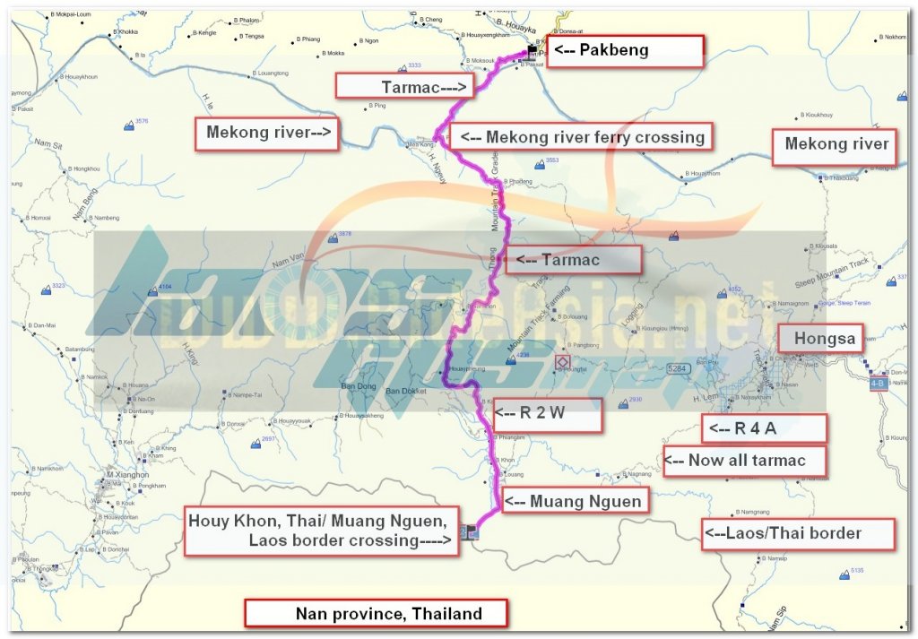
Yep tarmac all the way from the Muang Nguen, Laos border crossing to 3km before Hongsa village.


6809799126_77bda0d96f_b.jpg


In fact it would now be a fun ride on a sports bike along R 1148 & r 1080 to the Huay Khon, Thai / Muang Nguen, Laos border, cross into Laos and ride north on R 2 W to Pakbeng, good tarmac all the way with great curves. Also you could ride east on R 4 A to Hongsa and deal with the last 3 km being unpaved.


muang nguen to pakbeng.jpg


Lone Rider said:
Quick update on Rd. 4 and 4A based upon Phil's and my own observations.

Rd 4A from Mueng Ngeun to Hongsa is now paved except for a 3 km stretch just west of Hongsa so basically the whole road from Mueng Ngeun via Hongsa to Xayaboury is now paved.

From Xayaboury to the south, the first 20 km. is paved, then you get some 40-50 km of unpaved road with short paved stretches and after that is all the way paved (about 160 km.) to Paklay and the border to Thailand.
 
RD 1501 - Unpaved road from Nalae to Luang Nam Tha.

Last week while travelling from Nalea to Luang Nam Tha I had to wait for 2 hours (from 3 to 5 in the afternoon) as they were upgrading the road. It looks like that the road will be closed on a regular basis, at least that was what I was told and what the sign seems to say. The road will be widened and upgraded starting from the Luang Nam Tha side and should be completed sometime in 2014.

IMG_1737edit.jpg

The sign showing the opening/closing times

IMG_1735edit.jpg

Part of the road upgrading
 
Rd 1B - The Stone Road but not much longer

Everyone who travels to Phongsaly complains about the road - it is rocky, bumpy and everything which can fall of a bike will fall off due to the constant rattling of the bike. Last week when I was in that part of Laos I was ready for it but was pleasantly surprised that the upgrade of the road was going on and some 80% of the road was already improved to a certain extent. Not sure how it will keep up during the rainy season as sand and gravel used to cover the road may wash out again. The road will be paved and should be ready late next year according to the sign along the road. Below a few pictures of the upgrading going on.

IMG_1846edit.jpg


IMG_1847.jpg


IMG_1854edit.jpg


IMG_1842edit.jpg
 
Road 2 W (Pakbeng to Rd. 13N and Road 2E from Oudomxay to the Vietnam Border

Road 2 West (Muang Ngeun to Pakbeng and to Rd 13 North)

The part from Muang Ngeun to Pakbeng is good and all the land slides have been cleared. From Pakbeng to Rd. 13N the road condition is OK (December 2012) but the number of potholes has increased considerable and there are a few small spots in the first 10-25 km. north of Pakbeng which are bad.

Road 2 East (Oudomxai to Muang Khoua)

The condition of the road is good (December 2012) but there are a few bad spots where landslides have occurred which wiped out the pavement.

Road 2 East (Muang Khoua to the Panghok Lao Border Crossing to Vietnam)

This road is now paved all the way to the border and a joy to ride. All river crossings and the old bridges have been replaced by new bridges and/or culverts. They are still working on the bridges and all kinds of other things along the road but this does not hold up the traffic.

IMG_3256.jpg

The old and the new Sop Hun bridge


MUANGKHOUA.png

Low-Res GPS map screenshot of Muang Khoua and the new bridges

IMG_3244.jpg

The ferry in Muang Khoua - now retired

IMG_3230.jpg

IMG_3225.jpg

The new bridge over the Nam Phak

IMG_3226.jpg

IMG_3228.jpg

IMG_3227.jpg

The new bridge over the Nam Ou

IMG_3358.jpg

Bye-Bye river crossing - In the morning the bridge over the Nam Gnang was not yet open and I had to drive through the river but, when I came back from the Vietnam Border in the afternoon, the bridge was open for traffic.​
 
Still "on the road" but a quick update on the conditions of road 15:

Road 15 to the Vietnam border (Saravan to Ta Oy, Samoy and then on to the Vietnam border) is now all paved (from the immigration checkpoint to the border is still being worked on) and most of it is a kind of race track quality. The part close to Saravan up to the cement factory and the coal mine is getting potholed probably due to the heavy transport going on but once past the turnoff to the Sekong Coal mine the road is very good. Watch out though for a lot of loose gravel and grit in the curves.

Rd 15 Saravan to Rd 13 South (Ban Napong - the junction with all the grilled chicken sellers) is being upgraded and should be ready and paved in March 2014. Most of it is already high-speed dirt but at places it is very dusty with thick layers of the powdery dust.

Will post some pictures once back in Thailand.
 
Road 20/1H

The road from Saravane to the south to the Beng junction to Sekong (a few km. before you reach Tad Lo) is being worked on. Part of the road is being widened, the narrow bridges are being replaced with bigger ones, etc. At the moment it is a mess and I expect that it will get worse before it gets better. At the moment there are lots of short stretches where the asphalt pavement has been removed and there are sharp drops from the pavement to the gravel so watch out.

Don't know about the part further south as I only went to Tad Lo but I assume that the same will happen over there as there are also a lot of narrow bridges.
 
Road from Thakheak along the Mekong to Ban Kengkabao (Rd 5501 on the Laos Driven by Adventure GPS map) via Nongbok District.

The road which in the past was either a big mudhole or a dusty adventure depending on the season is now completely paved and is a nice alternative to the boring Road 13 from Thakheak to Savannakhet.
 
Thanks for the updates LR, looks like you're having quite a road trip over there. Any problems crossing into Laos?
 
RD 1D, 1E and 1F

Had heard from several people a.o. Mac and Armin Schoch that the stretch of Road 1D from Phonsavan to Thasi was now completed but was not sure about the part from Thasi via Viengthong and on to Rd 8. Happy to report that this part is now completely paved. There were 2 bridges which were not yet completely finished but I guess that before the rainy season starts, they may be finished as well
IMG_3889.jpg


IMG_3891.jpg


IMG_3890.jpg


IMG_3893.jpg


Road 1E from Lak Xao (on Rd 8) to Gnommalath (on Rd 12) is being worked on as well starting from the Lak Xao side.

About 2 months ago, when I came from the south (from Rd 6304) to Mahaxay which is also know as Rd 1F I saw them busy measuring and putting stakes along the road so I guess they will be upgrading that stretch of the road also in the near future.
 
North South Dirt link gone forever..

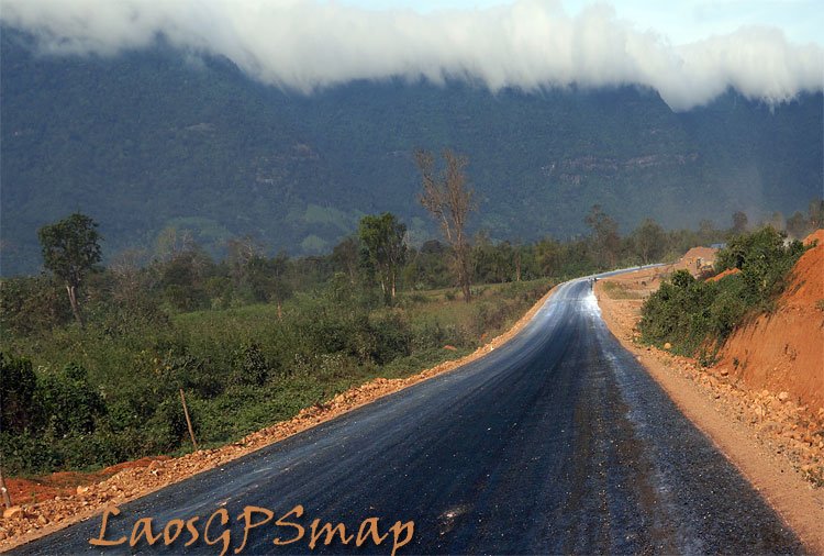
Here is a shot of the road to Samouy, looks pretty clean and easy ride now. Can still remember when only the hardened dirt rider dared this road. Kinda nice taking your lookers off the road and rocks in front of your wheel, and sit back and look at the magnificent scenery along this stretch.
 

Attachments

  • laos great roadsTa-Oy-road.jpg
    laos great roadsTa-Oy-road.jpg
    104.3 KB · Views: 1,321
Nice shot! is that a morning shot with the moisture rising and a slight breeze blowing it over the mountain?
 
So what road is not being improved upgraded in Laos? Vientiane building and road building boom has not abated at all. Thank goodness for your GPS to find your way home. The landscape everywhere is changing rapidly.Laosgpsmap.jpg

LaosGPSmap
 
Road 15 shot, is actually a roll cloud that just seems to park there during the Northeast Monsoon, "orthographic lifting" as the warm moist air from the Pacific Ocean rises to 1200 meters and pours over the escarpment." Friggin nice Willis"

New roads, logging and mining in this area, wow a mapper can never rest.

-----------------------------------------------------------------------------------------------------------------------------------
Orographic lift occurs when an air mass is forced from a low elevation to a higher elevation as it moves over rising terrain. As the air mass gains altitude it quickly cools down adiabatically, which can raise the relative humidity to 100% and create clouds and, under the right conditions, precipitation

Orographic lift - Wikipedia, the free encyclopedia
 
Highway 15

Highway15.jpg


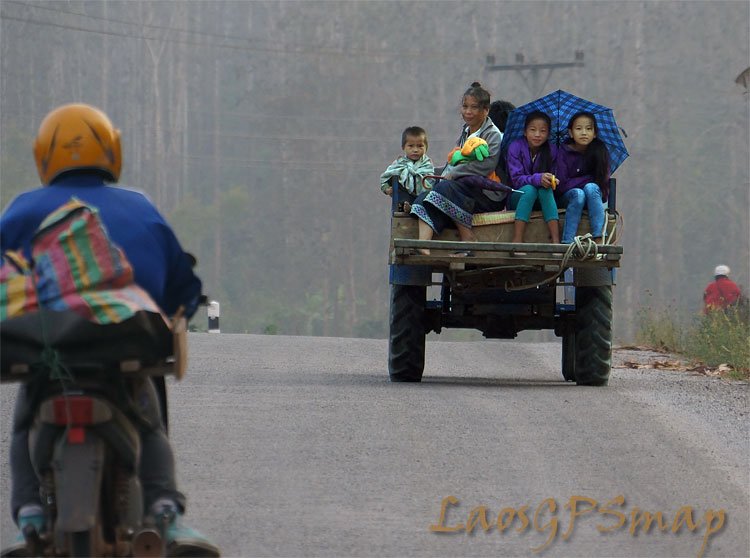
Road 15 from Saravan via Ta-Oi, Samouay and up to the border with Vietnam at Ban Lalo (Lay-Lay) where it links with Highway 14 in Vietnam is now paved all the way and a joy to ride with its sweeping curves over the hills.

IMG_3533.jpg


IMG_3514.jpg


IMG_3515.jpg


IMG_3526.jpg


One of the many new bridges which replaced the river crossing right next to it

IMG_3528.jpg
 
The new Kasy to Muang Nan Road

The new road from Kasy district in Vientiane province to Mueang Nan on Rd 4 from (Luang Prabang to Xayaboury) and onward to Luang Prabang now is expected to open in October, instead of its original schedule of June, Inpong Soukkhavong, the project director, told the Vientiane Times. The new road will slash 79 kilometres off the distance between the two locations.

The delay was due to the shortage of asphalt needed to seal the surface of the road, he added. This the second time the road has missed a completion deadline. It was originally deferred from January to June of this year, he said.

(Source: Vientiane Times)
 
Upgrade of Rd 6, 6a and 6B will take a bit more time as there is a cost overrun by US$21 million

The upgrade of roads 6A, 6B and 6 in the northern provinces of Huaphan and Xieng Khuang will be delayed to the end of this year as a further US$21 million is needed for the work. It was initially estimated that the project would cost about US$42.3 million, and the survey and design phase took place earlier this year.

Deputy Director of the Huaphan provincial Public Works and Transport Department, Mr Phonesouk Inthavong, told Vientiane Times on Monday that work on Road No. 6 has been delayed because of insufficient funding.
Of the US$42.3 million already earmarked, US$20 million will be sourced as a grant from the Asian Development Bank.

The Lao government will provide another US$10.3 million in the form of a low interest loan from the Organisation of Petroleum Exporting Countries (OPEC) and will source the remaining US$12 million from its own budget.
The objective of the project is to straighten out some of the many bends on these roads and reduce the number of accidents. The roads will also be widened from 4 metres to 6 metres.
But it has been discovered that the 263km long Road No. 6, which begins in Kham district in Xieng Khuang province needs a lot more work than originally planned because the road is very old and narrow.
The road ends at the Namsoy international checkpoint at the Vietnam border in Viengxay district Huaphan province. Vietnam has asked Laos to make the road the same width as the road on the Vietnamese side of the border, which is between 7 and 9 metres wide, to facilitate transportation between the two countries. The Namsoy checkpoint is the main border crossing in Huaphan province.

“We are looking at potential sources for the additional funding and may ask a private company to provide the necessary capital. Then the government would repay them when construction is complete,” Mr Phonesouk said.
Work on roads 6A and 6B, which run from the Hanglong area to Xopbao district in Huaphan province, will begin at the end of this year. A concrete bridge will be built in Xopbao district to cross the Nam Ma River (now a ferry crossing - added by LR), as well as a road from Xopbao district to the Pahang Lao-Vietnamese border crossing (local crossing only - added by LR).

Huaphan province shares a 600km border with the Vietnamese provinces of Thanh Hoa, Son La and Nghe An. Huaphan is home to about 22 ethnicities, predominantly the Tai Khao, as well as the Tai Daeng, Tai Meuang, Tai Neua, Phou Noi, Hmong, Khmu and Vietnamese. About 50 percent of the people in Huaphan province are classified as living below the poverty line. Poverty is most severe in the remote districts of Xamtay, Viengthong, Xopbao and Huameuang.

By Khonesavanh Latsaphao
(Latest Update May 21, 2013)
 
Govt to spend hundreds of millions on roads construction

(KPL) The Lao government will spend more than 68 trillion kip on construction and improvement of main roads countrywide to accomplish a plan to transform Lao PDR in a regional land link in the future. The plan aims also to ensure the national defence and safeguard, and will provide socio-economic development. The majority of the total budget will be spent to in new road construction, while more than 1.8 trillion kip will be used for the maintenance.

The Ministry of Public Works and Transport undertook the plan, which will last until 2015. Over 920 km of roads in three parts of the national territory: this is the target, according to the government's plan. The roads linking to the industrial development zones, special economic zone, border neighbouring countries and economic corridor will be the most sensitive ones.

There will be some national roads including national road No. 3, 1A, 8, 9, 12, 13S, 1D, 1E, 1F, 1G, 1H, 1I, 1J, 15 (A, B), 16 (A, B), and 18 (A, B) and others. In addition, the government has the ambitious plan to upgrade main roads in focal localities and develop village cluster to facilitate communication for all-year round.

Source: :: KPL :: Lao News Agency
 
Road 1G (Rd 23) to be upgraded and Paved

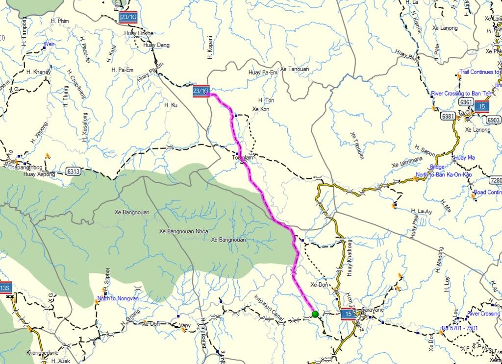
The construction of 64-km National Road No 1 G South, stretching from Savannakhet border to Nadonekhouang Village, Saravane Province, is planned to be renovated soon.

The project worth a total of 548.6 billion kip, partly financed with a Government contribution approved by the National Assembly in 2012-2013. According to the plan, this road will give access to seven villages of Saravane district and nine villages of Toumlan district, which are scheduled to be paved by asphalt. The renovation work is expected to be completed by next 48 months.

The construction of Road No 1 G is a national priority project, a strategic channel linking the north to the south. This road aims to serve the national defense and security, accessing to remote areas and connecting localities and districts with the central part and neighboring countries. Upon completion this road will spur the growth of economy, society, trade and investment in industry, creating jobs and upgrade living condition of the locals, favoring agriculture and tourism.

The contract for No 1 G road renovation was signed by Saravane Governor Khamboun Douangpanya and President of Douangchaleun Construction Company Group, Mr. Khamphai Silasha in Vientiane, on May 18. Witnesses of the event were the LT Gen. Duangchay Phicith, Deputy Prime Minister and Minister of National Defense, Mr. Sommath Pholsena, Minister of Public Works and Transport and various officials concerned.

Source: :: KPL :: Lao News Agency


Note by LR: The road improvement starts from Rd 15 and goes north up to the provincial border between Saravane and Savannakhet - this would leave the last 20 km. which is very bad (very difficult for cars as well as bikes) from the provincial border to the Xe Banghiang river in its present state.

23 1G.jpg
 
Hell that's a huge investment let me guess where the money is actually coming from.

Best get out there PDQ before all the fun has gone for good.
 
Saravan highway link with Road 13 South now half complete

Road 15A, which links Saravan provincial capital to Road No. 13 South in Napong village, Kong district, is now half built and the smooth surface is already providing a short cut to the capital. Head of the project in Saravan province, Mr Buachan Ouansavan, told Vientiane Times yesterday the agreement for the new road was signed in April 2011. Work began in October 2011 and is set for completion in April 2014.

“Now, road users can cut travel time to the provincial capital from three or four hours to just one hour. Even though the road isn't paved yet it is smooth enough to use,” he s aid. “We've laid asphalt on 4km of the road and will try to finish another 1km before the rainy season starts.”

When the rainy season does kick in, three sections of the road where bridges are being built are likely to provide an obstacle for road users. In these areas, small roads have been built to bypass channels and these will become flooded when it rains, Mr Buachan noted. But they would do their best to finish these three areas by the middle of the rainy season, he said. The 70km road runs from the provincial capital through the districts of Saravan, Vapee and Khong. The road has varying widths: in urban areas it is 11 metres wide, in villages it is 9 metres wide, and in non-residential areas it is 7 metres wide. Fifteen bridges will be built along the road altogether, while water supplies and drainage are also included.

The cost of the project is more than US$68.7 million. It includes a further 18km of asphalt roads in urban areas, the provision of water supplies and drainage, and additional roads to link towns to the outskirts of the province.

By Times Reporters
(Latest Update April 24, 2013)

Vientiane Times

IMG_3594.jpg
 
Rd 4 - Xayaboury Bridge over the Mekong to open in September 2013

A new bridge spanning the Mekong River to link two provinces in Laos will open by September, the Vientiane Times reported on Wednesday. The 620-metre span between Xayaboury and Luang Prabang provinces will also benefit Thailand, by facilitating land travellers from Loei and Nan provinces to the former royal capital, a main attraction in Laos.


Pheng Duangngue, director of the Public Works and Transport Department in Xayaboury province, told the Vientiane Times that the new bridge near Xayaboury provincial town would link the two riverbanks of the Mekong by the end of this month and will open by September. The bridge will replace ferry services used to connect the two Lao provinces, the official added. Construction on the bridge began in 2009, with loans from South Korea.

Source Bangkok Post Online News 12 June 2013
 
Back
Top Bottom