Captain_Slash
Community Manager
- Joined
- Jun 28, 2011
- Bikes
- BMW 310GS Honda Wave 125 Honda MSX 125
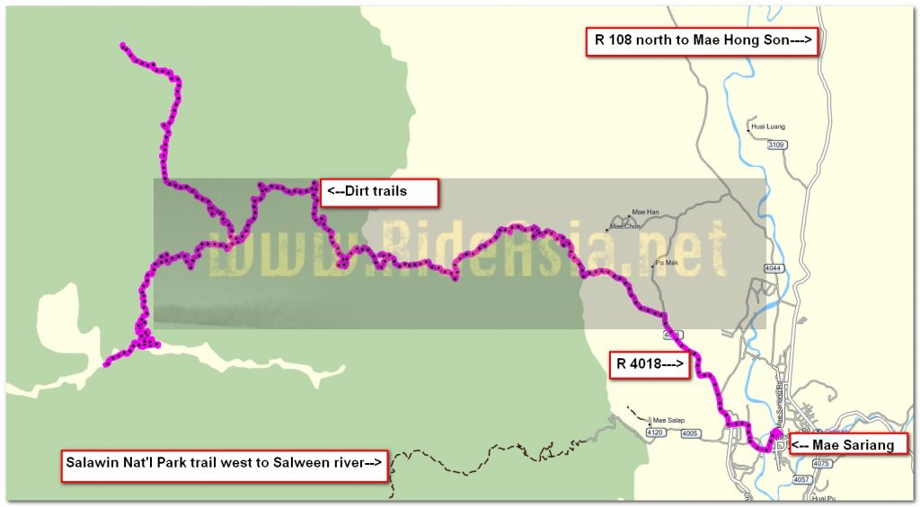
The Route 1194, 4018
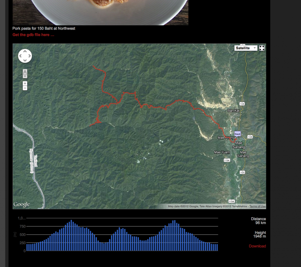
Total Distance 102 km

Just over 5 km out of town and I took a left onto a dirt track which started at N18.11.275 E097.53.974

This track goes to Huai Haeng then on to Mae Sakoep


Theres not much scenery to see as the trees blot out what does show through the haze


In places it was a loose surface mainly at the start and then the surface got firmer, I made a steady but not spectacular pace as I always had to be on my guard for rocky bits and ruts

I saw about three bikes on the way but its quite isolated out here


Descending into Huai Haeng


Thats the way to Mae Sakoep


I ride into the main part of the village to ask about fuel and its sold in bottles from a house here at N18.10.857 E097.45.672


Now to start the water crossing towards Mae Sakoep


To start with its okay as I am mainly crossing the river

In places there is a single track to avoid the water altogether


This is now the track


For as far as I can see now the track is the river bed


I am told its an hour to Mae Sakoep, if its riding in the river virtually all the way I would double that on a bike.
So two hours there and the same back, if I wanted to spend four hours in water I would go to a swimming pool.
I decide there and then to leave it and return to explore an off shoot of the main track in.
One thing is for sure, Mae Sakoep is unreachable by vehicles apart from in the dry season.
I was told its a big army base so I guess they reach it by boat or helicopter, if anyone has done this trip I would appreciate knowing how the route does go after this point


Enjoying the ride back


I take a left to ride another track that doesnt show on the GPS but the signpost gives a village 10 km further on


I do a few small water crossings like this


The track is now the river bed, I walk through and it soon gets back onto dry land around the corner and as I only have 2 more km to go I ride on


These kids are playing here and I guess the village is not far now

A few more water crossings and I am there

This guy is on the way back and says I can return to Mae Sariang the way I came or carry on through this village so I am guessing it must join up with the 3005 that goes to the Salawin WS.
I cant help thinking his bike would be so much better doing the water crossings as its that much lower and I would certainly feel a lot more confident on it


A rather large pig


Theres the road that goes on through


Most of the bikes here are equipped like this with knobbly tyres.
Fuel is sold in bottles here at N18.14.898 E097.45.097

Riding back, I get back to Mae Sariang and fill the KLX up, 102 km today and 91 of those on dirt.
It took 3.07 litres so thats 33 kpl, its not dirt riding that drinks the juice on the KLX its riding them fast on the road.
No wasting money on a bigger tank for me, my range is adequate as it is

Pork pasta for 150 Baht at Northwest
You can get the gdb file from my website here … http://www.captainslash.com
Total Distance 102 km

Just over 5 km out of town and I took a left onto a dirt track which started at N18.11.275 E097.53.974

This track goes to Huai Haeng then on to Mae Sakoep


Theres not much scenery to see as the trees blot out what does show through the haze


In places it was a loose surface mainly at the start and then the surface got firmer, I made a steady but not spectacular pace as I always had to be on my guard for rocky bits and ruts

I saw about three bikes on the way but its quite isolated out here


Descending into Huai Haeng


Thats the way to Mae Sakoep


I ride into the main part of the village to ask about fuel and its sold in bottles from a house here at N18.10.857 E097.45.672


Now to start the water crossing towards Mae Sakoep


To start with its okay as I am mainly crossing the river

In places there is a single track to avoid the water altogether


This is now the track


For as far as I can see now the track is the river bed


I am told its an hour to Mae Sakoep, if its riding in the river virtually all the way I would double that on a bike.
So two hours there and the same back, if I wanted to spend four hours in water I would go to a swimming pool.
I decide there and then to leave it and return to explore an off shoot of the main track in.
One thing is for sure, Mae Sakoep is unreachable by vehicles apart from in the dry season.
I was told its a big army base so I guess they reach it by boat or helicopter, if anyone has done this trip I would appreciate knowing how the route does go after this point


Enjoying the ride back


I take a left to ride another track that doesnt show on the GPS but the signpost gives a village 10 km further on


I do a few small water crossings like this


The track is now the river bed, I walk through and it soon gets back onto dry land around the corner and as I only have 2 more km to go I ride on


These kids are playing here and I guess the village is not far now

A few more water crossings and I am there

This guy is on the way back and says I can return to Mae Sariang the way I came or carry on through this village so I am guessing it must join up with the 3005 that goes to the Salawin WS.
I cant help thinking his bike would be so much better doing the water crossings as its that much lower and I would certainly feel a lot more confident on it


A rather large pig


Theres the road that goes on through


Most of the bikes here are equipped like this with knobbly tyres.
Fuel is sold in bottles here at N18.14.898 E097.45.097

Riding back, I get back to Mae Sariang and fill the KLX up, 102 km today and 91 of those on dirt.
It took 3.07 litres so thats 33 kpl, its not dirt riding that drinks the juice on the KLX its riding them fast on the road.
No wasting money on a bigger tank for me, my range is adequate as it is

Pork pasta for 150 Baht at Northwest
You can get the gdb file from my website here … http://www.captainslash.com


